1970s Maps of Hartland, Maine
Explore 4 historic maps of Hartland from the 1970s. These maps offer a rare glimpse into what life looked like during the 1970s — showing old roads, neighborhoods, homes, and landmarks that have changed or disappeared over time.
Whether you're researching your family's past, planning a metal detecting trip, or studying how Hartland's landscape evolved across the 1970s, these high-resolution maps are a powerful tool for exploring the history of this region.
- Focus on a specific era: All maps on this page are from the 1970s, giving you a focused view of this time period.
- See what’s changed: Compare century-old streets, trails, and buildings to today's modern landscape using overlays and satellite layers.
- Research with precision: Use these maps for genealogy, historical research, land use analysis, or educational projects.
- View, download, or print: Maps are fully viewable online in high resolution, and can be downloaded or printed for your own records.
Start exploring Hartland's history through authentic maps from the 1970s. This is your window into the past.
Hartland, ME maps
(4)- 1975 Map of Pittsfield SW, 1980 Print
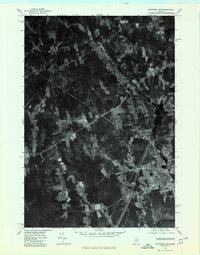 1975 Pittsfield SW1980 Print · USGSSomerset County, Maine, is captured in this mid-seventies aerial survey during a period of steady rural character. Researchers can trace the exact buildings and field lines of historic crossroads like West Palmyra, Emerson Corner, and Pittsfield.
 - 1975 Map of Pittsfield NW, 1980 Print
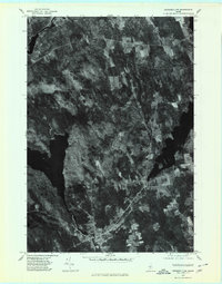 1975 Pittsfield NW1980 Print · USGSSomerset County's lake-strewn woods and small villages are captured from above in the mid-1970s. Genealogists and local historians can trace the rural layouts of St Albans and Hartland alongside landmarks like Great Moose Lake.
 - 1975 Map of Skowhegan SE, 1980 Print
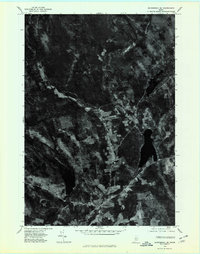 1975 Skowhegan SE1980 Print · USGSSomerset County in the mid-1970s is seen here through detailed aerial imagery, showing the patchwork of timber and farmland before later development. Researchers can trace the layout of small communities like Browns Corner or Mitchell Corner and locate family-named landmarks such as Whitten Hill.
 - 1975 Map of Skowhegan NE, 1980 Print
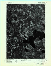 1975 Skowhegan NE1980 Print · USGSSomerset County, Maine, is captured in this mid-seventies orthophotograph showing the rural transition between forest and farmland. Genealogists and local historians can trace the clearings around Harmony and Mainstream or study the shoreline of Moose Pond.
End of results
Showing maps 1-4 of 4
Top cities near Hartland
- Fairfield historical maps
- Skowhegan historical maps
- Madison historical maps
- Pittsfield historical maps
- Dexter historical maps
- Clinton historical maps
See more
Top neighborhoods of Hartland
Frequently asked questions
- What are the different types of historical maps available for Hartland?
- What is the oldest map of Hartland?
- Where can I purchase historical maps of Hartland for my home or office?
- Where can I download high-res historical maps of Hartland?
- Are there historical topographic maps available for Hartland?
- Is there historical aerial imagery available for Hartland?
- Where are historical maps of Hartland sourced from?