1970s Maps of Moscow, Maine
Explore 4 historic maps of Moscow from the 1970s. These maps offer a rare glimpse into what life looked like during the 1970s — showing old roads, neighborhoods, homes, and landmarks that have changed or disappeared over time.
Whether you're researching your family's past, planning a metal detecting trip, or studying how Moscow's landscape evolved across the 1970s, these high-resolution maps are a powerful tool for exploring the history of this region.
- Focus on a specific era: All maps on this page are from the 1970s, giving you a focused view of this time period.
- See what’s changed: Compare century-old streets, trails, and buildings to today's modern landscape using overlays and satellite layers.
- Research with precision: Use these maps for genealogy, historical research, land use analysis, or educational projects.
- View, download, or print: Maps are fully viewable online in high resolution, and can be downloaded or printed for your own records.
Start exploring Moscow's history through authentic maps from the 1970s. This is your window into the past.
Moscow, ME maps
(4)- 1975 Map of Bingham SE, 1980 Print
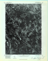 1975 Bingham SE1980 Print · USGSIn the mid-1970s, this Somerset County landscape was a mosaic of timberland and winding waterways. Researchers can trace the path of the Kennebec River and locate isolated features like Withee Pond or the heights of Johnson Mountain.
 - 1975 Map of Bingham NE, 1980 Print
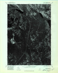 1975 Bingham NE1980 Print · USGSThe Maine woods of the mid-1970s are captured in this aerial orthophotograph of the Somerset County backcountry. Researchers can trace the timber roads and drainage patterns around Austin Pond and Dimmick Mountain.
 - 1975 Map of Bingham NW, 1980 Print
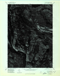 1975 Bingham NW1980 Print · USGSThe Maine woods and the upper Kennebec River are captured in high detail in the mid-1970s. Researchers can trace the terrain and water systems of Somerset County, from the depths of Pleasant Pond to the peaks of Moxie Mountain.
 - 1975 Map of Bingham SW, 1980 Print
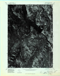 1975 Bingham SW1980 Print · USGSThe upper Kennebec River valley is captured here in the mid-1970s through high-resolution aerial imagery. Genealogists and researchers can trace the exact footprint of settlements in Bingham and Moscow or locate terrain features like Old Bluff Mountain.
End of results
Showing maps 1-4 of 4
Top cities near Moscow
- Madison historical maps
- Cornville historical maps
- Solon historical maps
- Athens historical maps
- Embden historical maps
- Bingham historical maps
See more
Top neighborhoods of Moscow
Frequently asked questions
- What are the different types of historical maps available for Moscow?
- What is the oldest map of Moscow?
- Where can I purchase historical maps of Moscow for my home or office?
- Where can I download high-res historical maps of Moscow?
- Are there historical topographic maps available for Moscow?
- Is there historical aerial imagery available for Moscow?
- Where are historical maps of Moscow sourced from?