1970s Maps of Soldiertown Township, Maine
Explore 5 historic maps of Soldiertown Township from the 1970s. These maps offer a rare glimpse into what life looked like during the 1970s — showing old roads, neighborhoods, homes, and landmarks that have changed or disappeared over time.
Whether you're researching your family's past, planning a metal detecting trip, or studying how Soldiertown Township's landscape evolved across the 1970s, these high-resolution maps are a powerful tool for exploring the history of this region.
- Focus on a specific era: All maps on this page are from the 1970s, giving you a focused view of this time period.
- See what’s changed: Compare century-old streets, trails, and buildings to today's modern landscape using overlays and satellite layers.
- Research with precision: Use these maps for genealogy, historical research, land use analysis, or educational projects.
- View, download, or print: Maps are fully viewable online in high resolution, and can be downloaded or printed for your own records.
Start exploring Soldiertown Township's history through authentic maps from the 1970s. This is your window into the past.
Soldiertown Township, ME maps
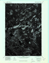
(5)- 1976 Map of Sherbrooke
 1976 Sherbrooke1976 Print · USGSThe northern Maine woods and Quebec’s Eastern Townships meet in this mid-century survey of the rugged international borderlands. Genealogists and historians can trace rail-and-river connections through Thetford Mines, follow the Dead River to Flagstaff Lake, or locate small border crossings at Stanhope and Beecher Falls.2 unique versions available
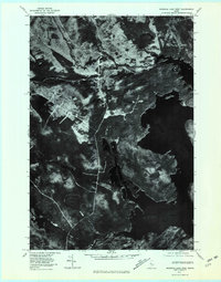
 - 1977 Map of Tomhegan Pond, 1981 Print
 1977 Tomhegan Pond1981 Print · USGSMaine's northern interior remains a quiet landscape of water and wood in the late seventies. You can trace the winding South Branch Penobscot River and examine the natural shorelines of Tomhegan Pond and Center Pond.
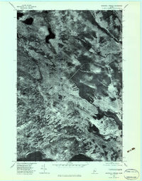
 - 1977 Map of Brassua Lake West, 1981 Print
 1977 Brassua Lake West1981 Print · USGSThe Maine North Woods in the late seventies come into focus in this detailed orthophotoquad showing the timberlands around Brassua Lake. Researchers can study the historical hydrology and forest cover near Moose River and Tom Fletcher Hill.
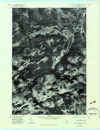
 - 1979 Map of Churchill Stream, 1983 Print
 1979 Churchill Stream1983 Print · USGSSomerset County's dense timberlands and waterways are captured in detail at the close of the seventies. Researchers can trace the precise flow of Churchill Stream and the northern reaches of Long Pond across this aerial orthophoto.
 - 1979 Map of Canada Falls Lake, 1983 Print
 1979 Canada Falls Lake1983 Print · USGSSomerset County, Maine, is captured in this late 1970s orthophotoquad showing the northern wilderness at a transition point in modern land management. Trace the winding shoreline of Canada Falls Lake and the intricate bends of the South Branch Penobscot River.
End of results
Showing maps 1-5 of 5
Top cities near Soldiertown Township
Frequently asked questions
- What are the different types of historical maps available for Soldiertown Township?
- What is the oldest map of Soldiertown Township?
- Where can I purchase historical maps of Soldiertown Township for my home or office?
- Where can I download high-res historical maps of Soldiertown Township?
- Are there historical topographic maps available for Soldiertown Township?
- Is there historical aerial imagery available for Soldiertown Township?
- Where are historical maps of Soldiertown Township sourced from?