1900s (20th Century) Maps of St. Zacharie, T5 R20 WELS
Explore 5 historic maps of St. Zacharie from the 1900s (20th Century). These maps offer a rare glimpse into what life looked like during the 1900s — showing old roads, neighborhoods, homes, and landmarks that have changed or disappeared over time.
Whether you're researching your family's past, planning a metal detecting trip, or studying how St. Zacharie's landscape evolved across the 1900s, these high-resolution maps are a powerful tool for exploring the history of this region.
- Focus on a specific era: All maps on this page are from the 1900s, giving you a focused view of this time period.
- See what’s changed: Compare century-old streets, trails, and buildings to today's modern landscape using overlays and satellite layers.
- Research with precision: Use these maps for genealogy, historical research, land use analysis, or educational projects.
- View, download, or print: Maps are fully viewable online in high resolution, and can be downloaded or printed for your own records.
Start exploring St. Zacharie's history through authentic maps from the 1900s. This is your window into the past.
St. Zacharie, T5 R20 WELS maps
(5)- 1957 Map of Saint Zacharie, 1961 Print
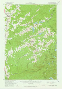 1957 Saint Zacharie1961 Print · USGSThe northern Maine borderlands and adjacent Quebec parishes are captured here in the late fifties, showcasing a remote timber and farming region. Genealogists and historians can trace lineage across the boundary near St Zacharie and Ste Aurelie, or locate isolated camps like La Croix Depot.3 unique versions available
 - 1962 Map of Quebec, 1966 Print
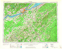 1962 Quebec1966 Print · USGSThe cross-border region between Quebec and Northern Maine is captured here during the mid-1960s, showing the dense settlement of the St. Lawrence valley and the rugged timberlands of the frontier. Genealogists can trace family roots through numerous parishes like St-Joseph-de-Beauce or locate the industrial hubs of Thetford Mines and Levis.3 unique versions available
 - 1986 Map of Lac Etchemin
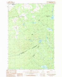
 1986 Lac Etchemin1986 Print · USGSThe Maine North Woods at the Quebec border are shown here as a landscape of timber management and remote river branches. Genealogists and historians can trace the logging history at Billy-Jack Depot and the headwaters of the St John River.
 - 1989 Map of Hurricane Pond
 1989 Hurricane Pond1989 Print · USGSThe Maine-Quebec borderlands come into focus in the late 1980s, documenting a remote landscape of international timberlands and headwaters. Trace the winding St John River and remote features like Hurricane Pond, Little St John Lake, and the border settlement of Lavery.
 - 1993 Map of Lac Etchemin
 1993 Lac Etchemin1993 Print · USGSThe borderlands of Maine and Quebec in the 1990s are defined here by the international boundary cutting through dense timberlands and the Beauce valley. Researchers can trace the Port of Entry near the Saint John River Southwest Branch and explore the layouts of Beauceville and Lac-Etchemin.
End of results
Showing maps 1-5 of 5
Frequently asked questions
- What are the different types of historical maps available for St. Zacharie?
- What is the oldest map of St. Zacharie?
- Where can I purchase historical maps of St. Zacharie for my home or office?
- Where can I download high-res historical maps of St. Zacharie?
- Are there historical topographic maps available for St. Zacharie?
- Is there historical aerial imagery available for St. Zacharie?
- Where are historical maps of St. Zacharie sourced from?