Old Maps of West Forks, Maine for Metal Detecting
Plan your next treasure hunt with 46 historic maps of West Forks. Find old homesites, ghost towns, trails, and gathering spots that may be lost to time — perfect for identifying promising metal detecting locations.
- Locate forgotten sites: Uncover places like long-lost settlements, abandoned rail lines, or gathering spots.
- Plan better hunts: Use map overlays combined with LiDAR or satellite views to narrow in on historically rich areas.
- Made for detectorists: Thousands of hobbyists use these maps to discover relics, coins, and hidden history.
Use these historic maps to boost your research and find new opportunities beneath the surface of West Forks.
West Forks, ME maps
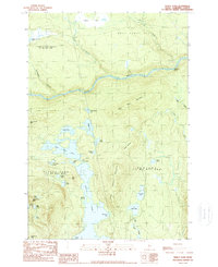
(46)- 1905 Map of The Forks, 1954 Print
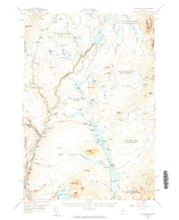
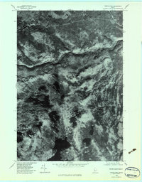
 1905 The Forks1954 Print · USGSThe Forks region of Somerset County was a wild landscape of timber tracts and river junctions at the turn of the century. You can trace the early logging routes along the Tote Road and locate remote landmarks like Squirt Gun Dam and the 10000 Acre Tract.
 - 1907 Map of The Forks
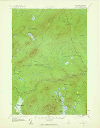
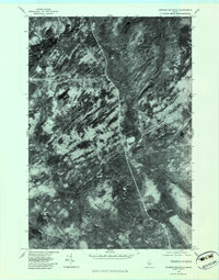
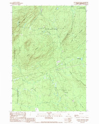
 1907 The Forks1907 Print · USGSSomerset County's logging heartland is captured at a pivotal moment as the Somerset R. R. pushed north toward the boundary. Local historians can trace early timber camps and river infrastructure like Squirtgun Dam and the Tote Road near The Forks.4 unique versions available
 - 1925 Map of Pierce Pond
 1925 Pierce Pond1925 Print · USGSSomerset County in the mid-twenties was a landscape of remote timberlands and sporting camps connected by river landings. Genealogists and historians can trace early wilderness outposts like Grace Pond Camp and industrial markers like Spencer Dam or the Coburn Mtn Lookout Station.2 unique versions available
 - 1927 Map of Pierce Pond
 1927 Pierce Pond1927 Print · USGSThe remote Maine woods of Somerset County come alive in this mid-1920s survey of the Upper and Lower Enchanted territories. Genealogists and historians can trace early wilderness outposts like Salmon Streams Farm, West Forks, and the riverside Hayden Landing.6 unique versions available
 - 1944 Map of Pierce Pond
 1944 Pierce Pond1944 Print · USGSSomerset County was a rugged frontier of logging camps and sporting lodges during the mid-1940s. Researchers can locate remote outposts like Stony Brook Camp, Depot Camp, and the Pierce Pond Camps along the winding Dead River.
 - 1949 Map of Jackman
 1949 Jackman1949 Print · USGSThe Quebec and Maine borderlands are shown in great detail during the late 1940s, highlighting the industrial and natural geography of the region. Trace old rail lines like the Canadian Pacific and locate settlements from Sherbrooke to Scotstown.2 unique versions available
 - 1954 Map of Millinocket, 1968 Print
 1954 Millinocket1968 Print · USGSMaine's North Woods and the Penobscot Valley are captured here during the mid-century era of logging and rail dominance. You can trace the path of the Bangor and Aroostook Railroad through timber towns like Millinocket, Mattawamkeag, and Silver Ridge.3 unique versions available
 - 1956 Map of The Forks, 1961 Print
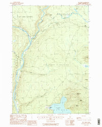
 1956 The Forks1961 Print · USGSSomerset County’s river-driven landscape is captured here in the mid-fifties, centered on the vital junction of the Kennebec River. Genealogists and historians can locate the Franklin Sch, trace the old route of Shirley Road, and find the lakeside settlement of Troutdale.5 unique versions available
 - 1958 Map of Millinocket
 1958 Millinocket1958 Print · USGSMaine's North Woods and the Penobscot river valley are captured here in the mid-1950s, showing a landscape of timber, rail, and wild waters. Researchers can trace the legacy of the Canadian Pacific railroad and find historic settlements like Millinocket, Sherman Station, and Mattawamkeag.
 - 1958 Map of Pierce Pond, 1960 Print
 1958 Pierce Pond1960 Print · USGSSomerset County's remote townships and river corridors are meticulously charted during the mid-century peak of the Maine sporting camp tradition. Researchers can locate established backcountry sites like Grace Pond Camp, the fields of Salmon Stream Farm, and the waters of Enchanted Pond.3 unique versions available
 - 1960 Map of Millinocket
 1960 Millinocket1960 Print · USGSThe Maine North Woods and Penobscot River valley are captured at mid-century during the height of the paper milling era. Researchers can trace the Appalachian Trail near Mount Katardin or locate family roots in towns like Dover-Foxcroft and Milo.3 unique versions available
 - 1963 Map of Jackman
 1963 Jackman1963 Print · USGSThe international borderlands of Maine and Quebec come alive in the mid-twentieth century, showing a landscape of timber towns and rail connections. Genealogists and historians can trace the paths of the Canadian Pacific Railway through Jackman or locate families in Sherbrooke and Megantic.
 - 1966 Map of Sherbrooke
 1966 Sherbrooke1966 Print · USGSThe borderlands of Quebec and Maine come alive in the mid-1960s, documenting the industrial towns and deep woods of the Northeast. Genealogists can trace family lines through Sherbrooke and Coaticook, or locate remote logging outposts along the Moose River and Flagstaff Lake.
 - 1976 Map of Sherbrooke
 1976 Sherbrooke1976 Print · USGSThe northern Maine woods and Quebec’s Eastern Townships meet in this mid-century survey of the rugged international borderlands. Genealogists and historians can trace rail-and-river connections through Thetford Mines, follow the Dead River to Flagstaff Lake, or locate small border crossings at Stanhope and Beecher Falls.2 unique versions available
 - 1977 Map of Black Brook Pond, 1981 Print
 1977 Black Brook Pond1981 Print · USGSThe upper Kennebec region in the late seventies is captured here through aerial orthophotography. Trace the winding Kennebec River and identify the precise shorelines of Black Brook Pond and Chase Stream.
 - 1977 Map of The Forks, 1981 Print
 1977 The Forks1981 Print · USGSMaine's northern river country is captured here in the late seventies, showing the vital confluence of the Dead River and Kennebec River. Trace the early roads and settlements at The Forks or explore the rugged slopes of Pleasant Pond Mountain.
 - 1979 Map of Pierce Pond, 1983 Print
 1979 Pierce Pond1983 Print · USGSMaine's Somerset County highlands appear in high-resolution detail during the late seventies, showing a landscape defined by timber and water. Trace the rugged path of the Dead River or explore the intricate shorelines of Pierce Pond and Otter Pond Mountain.
 - 1979 Map of Johnson Mountain, 1983 Print
 1979 Johnson Mountain1983 Print · USGSThe timberlands around West Forks are shown through detailed aerial photography in the late 1970s. Researchers can trace the logging roads and forest drainage patterns near Johnson Mountain and Cold Stream.
 - 1986 Map of Flagstaff Lake
 1986 Flagstaff Lake1986 Print · USGSThe Maine North Woods and the Dead River valley are captured here in the mid-1980s, an era of established hydroelectric lakes and outdoor recreation. Genealogists and researchers can trace the vicinity of Kennebago Settlement, Langtown Mill, and the villages of Stratton and Eustis.
 - 1986 Map of Dover-Foxcroft
 1986 Dover-Foxcroft1986 Print · USGSPiscataquis County at the edge of the great Maine woods is documented here in the mid-1980s, centered on the river-and-rail hubs of the interior. Trace the industrial footprints of Dover South Mills, the rail yards at Brownville Junction, or the historic Katahdin Iron Works.
 - 1988 Map of The Forks
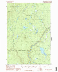
 1988 The Forks1988 Print · USGSThe Forks region in the late 1980s reveals the rugged confluence of the Kennebec River and Dead River. You can trace the path of the Appalachian National Scenic Trail and locate landmarks like Moxie Falls and Pleasant Pond.2 unique versions available
 - 1988 Map of Black Brook Pond
 1988 Black Brook Pond1988 Print · USGSSomerset County’s northern woods appear in the late eighties as a network of timber tracts and river drainages. Genealogists and historians can trace the borders of West Forks Plantation and search for landmarks like Cold Stream Mtn and Black Brook Pond.2 unique versions available
 - 1989 Map of Pierce Pond
 1989 Pierce Pond1989 Print · USGSThe northern Maine wilderness of the late 1980s is defined here by the winding Dead River and its surrounding peaks. Researchers can trace the complex shoreline of Pierce Pond, locate remote points like Poplar Hill Falls, or study the elevations of Hurricane Mtn.2 unique versions available
 - 1989 Map of Johnson Mountain
 1989 Johnson Mountain1989 Print · USGSSomerset County was a land of timber and trout streams in the late 1980s. Historians and outdoor enthusiasts can trace the landscape from the heights of Coburn Mountain down to Cold Stream Falls and the settlement at West Forks.
 - 1994 Map of Dover-Foxcroft
 1994 Dover-Foxcroft1994 Print · USGSCentral Maine in the mid-nineties shows a landscape of timber-driven towns and deep glacial lakes. Trace the paths of the Canadian Pacific RR or locate the Moscow Air Force Station Transmit Site and Sebec Lake.
Showing maps 1-25 of 46
Top cities near West Forks
Frequently asked questions
- What are the different types of historical maps available for West Forks?
- What is the oldest map of West Forks?
- Where can I purchase historical maps of West Forks for my home or office?
- Where can I download high-res historical maps of West Forks?
- Are there historical topographic maps available for West Forks?
- Is there historical aerial imagery available for West Forks?
- Where are historical maps of West Forks sourced from?