1980s Maps of West Forks, Maine
Explore 6 historic maps of West Forks from the 1980s. These maps offer a rare glimpse into what life looked like during the 1980s — showing old roads, neighborhoods, homes, and landmarks that have changed or disappeared over time.
Whether you're researching your family's past, planning a metal detecting trip, or studying how West Forks's landscape evolved across the 1980s, these high-resolution maps are a powerful tool for exploring the history of this region.
- Focus on a specific era: All maps on this page are from the 1980s, giving you a focused view of this time period.
- See what’s changed: Compare century-old streets, trails, and buildings to today's modern landscape using overlays and satellite layers.
- Research with precision: Use these maps for genealogy, historical research, land use analysis, or educational projects.
- View, download, or print: Maps are fully viewable online in high resolution, and can be downloaded or printed for your own records.
Start exploring West Forks's history through authentic maps from the 1980s. This is your window into the past.
West Forks, ME maps
(6)- 1986 Map of Flagstaff Lake
 1986 Flagstaff Lake1986 Print · USGSThe Maine North Woods and the Dead River valley are captured here in the mid-1980s, an era of established hydroelectric lakes and outdoor recreation. Genealogists and researchers can trace the vicinity of Kennebago Settlement, Langtown Mill, and the villages of Stratton and Eustis.
 - 1986 Map of Dover-Foxcroft
 1986 Dover-Foxcroft1986 Print · USGSPiscataquis County at the edge of the great Maine woods is documented here in the mid-1980s, centered on the river-and-rail hubs of the interior. Trace the industrial footprints of Dover South Mills, the rail yards at Brownville Junction, or the historic Katahdin Iron Works.
 - 1988 Map of The Forks
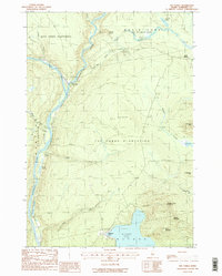 1988 The Forks1988 Print · USGSThe Forks region in the late 1980s reveals the rugged confluence of the Kennebec River and Dead River. You can trace the path of the Appalachian National Scenic Trail and locate landmarks like Moxie Falls and Pleasant Pond.2 unique versions available
 - 1988 Map of Black Brook Pond
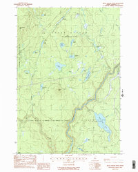 1988 Black Brook Pond1988 Print · USGSSomerset County’s northern woods appear in the late eighties as a network of timber tracts and river drainages. Genealogists and historians can trace the borders of West Forks Plantation and search for landmarks like Cold Stream Mtn and Black Brook Pond.2 unique versions available
 - 1989 Map of Pierce Pond
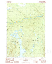 1989 Pierce Pond1989 Print · USGSThe northern Maine wilderness of the late 1980s is defined here by the winding Dead River and its surrounding peaks. Researchers can trace the complex shoreline of Pierce Pond, locate remote points like Poplar Hill Falls, or study the elevations of Hurricane Mtn.2 unique versions available
 - 1989 Map of Johnson Mountain
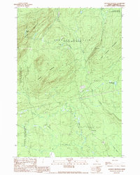 1989 Johnson Mountain1989 Print · USGSSomerset County was a land of timber and trout streams in the late 1980s. Historians and outdoor enthusiasts can trace the landscape from the heights of Coburn Mountain down to Cold Stream Falls and the settlement at West Forks.
End of results
Showing maps 1-6 of 6
Top cities near West Forks
Frequently asked questions
- What are the different types of historical maps available for West Forks?
- What is the oldest map of West Forks?
- Where can I purchase historical maps of West Forks for my home or office?
- Where can I download high-res historical maps of West Forks?
- Are there historical topographic maps available for West Forks?
- Is there historical aerial imagery available for West Forks?
- Where are historical maps of West Forks sourced from?