1940s Maps of Marion Township, Maine
Explore 2 historic maps of Marion Township from the 1940s. These maps offer a rare glimpse into what life looked like during the 1940s — showing old roads, neighborhoods, homes, and landmarks that have changed or disappeared over time.
Whether you're researching your family's past, planning a metal detecting trip, or studying how Marion Township's landscape evolved across the 1940s, these high-resolution maps are a powerful tool for exploring the history of this region.
- Focus on a specific era: All maps on this page are from the 1940s, giving you a focused view of this time period.
- See what’s changed: Compare century-old streets, trails, and buildings to today's modern landscape using overlays and satellite layers.
- Research with precision: Use these maps for genealogy, historical research, land use analysis, or educational projects.
- View, download, or print: Maps are fully viewable online in high resolution, and can be downloaded or printed for your own records.
Start exploring Marion Township's history through authentic maps from the 1940s. This is your window into the past.
Marion Township, ME maps
(2)- 1941 Map of Gardner Lake, 1958 Print
 1941 Gardner Lake1958 Print · USGSWashington County during the early 1940s was a landscape of remote timberlands and tight-knit settlements along the Maine Central line. Genealogists and historians can locate rural schoolhouses like Gardner Lake Sch and vanished local hubs such as Chase Mills and Halls Mills.3 unique versions available
 - 1943 Map of Gardner Lake
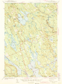 1943 Gardner Lake1943 Print · USGSWashington County's lake-country comes alive in this early 1940s survey, showing a landscape of remote mills and scattered schoolhouses. Researchers can trace family sites near Marion or locate old landmarks like the Gardner Lake Sch and the firetower on Cooper Hill.3 unique versions available
End of results
Showing maps 1-2 of 2
Top cities near Marion Township
- Machias historical maps
- East Machias historical maps
- Jonesport historical maps
- Lubec historical maps
- Machiasport historical maps
- Perry historical maps
See more
Frequently asked questions
- What are the different types of historical maps available for Marion Township?
- What is the oldest map of Marion Township?
- Where can I purchase historical maps of Marion Township for my home or office?
- Where can I download high-res historical maps of Marion Township?
- Are there historical topographic maps available for Marion Township?
- Is there historical aerial imagery available for Marion Township?
- Where are historical maps of Marion Township sourced from?