1940s Maps of Wells, Maine
Explore 8 historic maps of Wells from the 1940s. These maps offer a rare glimpse into what life looked like during the 1940s — showing old roads, neighborhoods, homes, and landmarks that have changed or disappeared over time.
Whether you're researching your family's past, planning a metal detecting trip, or studying how Wells's landscape evolved across the 1940s, these high-resolution maps are a powerful tool for exploring the history of this region.
- Focus on a specific era: All maps on this page are from the 1940s, giving you a focused view of this time period.
- See what’s changed: Compare century-old streets, trails, and buildings to today's modern landscape using overlays and satellite layers.
- Research with precision: Use these maps for genealogy, historical research, land use analysis, or educational projects.
- View, download, or print: Maps are fully viewable online in high resolution, and can be downloaded or printed for your own records.
Start exploring Wells's history through authentic maps from the 1940s. This is your window into the past.
Wells, ME maps
(8)- 1941 Map of Biddeford, 1952 Print
 1941 Biddeford1952 Print · USGSThe York County coastline during the early years of the war reveals a landscape of tidal harbors and rural school districts. Genealogists and historians can locate family plots at Laurel Hill Cem or trace old routes like Guinea Road past the Nott Sch.2 unique versions available
 - 1941 Map of Kennebunk, 1952 Print
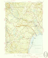
 1941 Kennebunk1952 Print · USGSCoastal Maine in the early 1940s reveals a landscape of industrial mill sites and growing seaside resorts connected by the nascent Maine Turnpike. Genealogists can trace family roots through numerous numbered schoolhouses and landmarks like Merriland Ch and Evergreen Cem.2 unique versions available
 - 1944 Map of Wells
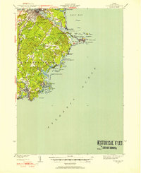
 1944 Wells1944 Print · USGSThe Maine coast near the end of the war shows a landscape of tidal marshes and rail-connected villages. Researchers can find old landmarks like the Wells Poor Farm, Old Wharf, and the Evergreen Cem near Kennebunk Beach.
 - 1944 Map of York Beach
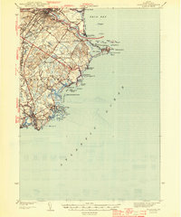
 1944 York Beach1944 Print · USGSCoastal Maine at the height of the mid-century shows a landscape of rocky shores and growing seaside communities. Genealogists and local historians can trace family-named landmarks and old infrastructure like Perkins Cove, Cape Neddick LH, and the Old RR Grade.2 unique versions available
 - 1944 Map of Biddeford
 1944 Biddeford1944 Print · USGSCoastal York County at the start of the 1940s reveals a blend of textile-mill industry, storied summer resorts, and rugged maritime life. Researchers can trace the old schoolhouse network including Nell Sch, the grounds of St Francis College, and the waterfront at Cape Porpoise.2 unique versions available
 - 1944 Map of Kennebunk
 1944 Kennebunk1944 Print · USGSCoastal Maine thrives along the rivers and rails of York County in the early 1940s. Genealogists and historians can trace family roots through numerous local landmarks, from Evergreen Cem and Merriland Ch to the many numbered schoolhouses like School No 10.2 unique versions available
 - 1949 Map of Portland
 1949 Portland1949 Print · USGSCoastal Maine and the New Hampshire interior are shown in detail during the late forties, from the bustling harbors to the lakeside villages. Researchers can trace historical rail networks like the Boston & Maine RR and locate coastal defenses such as Fort Preble.3 unique versions available
 - 1949 Map of Wells
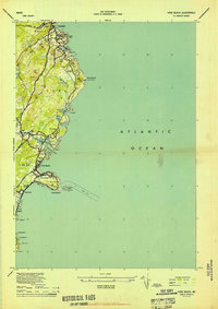
 1949 Wells1949 Print · USGSThe Maine coast in the late 1940s shows a landscape of tidal marshes and growing shorefront communities like Wells Beach (Webhannet PO). Genealogists and historians can trace old landmarks such as the Wells Poor Farm, rural schoolhouses like Wells Sch No 3, and the path of the Boston and Maine RR.
End of results
Showing maps 1-8 of 8
Top cities near Wells
- Dover historical maps
- Biddeford historical maps
- Sanford historical maps
- Scarborough historical maps
- Portsmouth historical maps
- Saco historical maps
See more
Top neighborhoods of Wells
- Drakes Island historical maps
- Upper Landing historical maps
- Wells Beach historical maps
- Cozy Corners historical maps
- Parsonage Corner historical maps
- Tatnic historical maps
See more
Frequently asked questions
- What are the different types of historical maps available for Wells?
- What is the oldest map of Wells?
- Where can I purchase historical maps of Wells for my home or office?
- Where can I download high-res historical maps of Wells?
- Are there historical topographic maps available for Wells?
- Is there historical aerial imagery available for Wells?
- Where are historical maps of Wells sourced from?