Old Maps of Cumberland, Maryland
Explore 38 old maps of Cumberland, spanning from 1898 to today. These high-resolution historic maps reveal how streets, neighborhoods, landmarks, and natural features evolved over time — perfect for genealogy, metal detecting, research, and local history exploration.
What you can do with these maps:
- See how Cumberland changed over time: Compare historical maps to modern-day views to trace roads, homesites, rail lines & more.
- View detailed metadata: Each map includes creators, publishers, year, scale, and archive source.
- Overlay maps with satellite & LiDAR: Visualize the past alongside modern tools to explore terrain & human change.
- Trusted historical sources: Maps sourced from the USGS, Library of Congress, and other archives.
- Access maps your way: View online, download high-res files, or order prints for personal or research use.
Start exploring old maps of Cumberland to uncover forgotten places, hidden landmarks, and the deep history beneath your feet.
Cumberland, MD maps
(38)- 1898 Map of Frostburg
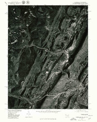
 1898 Frostburg1898 Print · USGSMaryland's coal country and the Potomac borderlands are captured here at the height of the Victorian industrial era. Researchers can trace the extensive rail lines and mining infrastructure connecting settlements like Eckhart Mines, Mount Savage, and the historic C & O Canal.
 - 1899 Map of Flintstone
 1899 Flintstone1899 Print · USGSThe Maryland, West Virginia, and Pennsylvania borders converge here during the late nineteenth century as industry follows the river. Genealogists can trace family footprints near Oldtown or locate vanished infrastructure like Patterson Depot and the C. & O. Canal.
 - 1900 Map of Flintstone
 1900 Flintstone1900 Print · USGSThe Maryland and West Virginia border at the close of the nineteenth century centers on the vital Potomac River transportation corridor. Researchers can trace the Chesapeake and Ohio Canal, the B. & O. R. R., and early settlements like Oldtown, Flintstone, and Wolf Mill.6 unique versions available
 - 1901 Map of Frostburg
 1901 Frostburg1901 Print · USGSMaryland's coal country and the critical mountain pass at Cumberland are shown in detail at the turn of the century. Genealogists and industrial historians can locate old mining works at Eckhart Mines, the path of the C. & O. Canal, and the early layout of Frostburg.2 unique versions available
 - 1908 Map of Frostburg
 1908 Frostburg1908 Print · USGSAllegany County mining and rail networks are in full view at the turn of the century. Trace the old coal patches and rail spurs from Eckhart Mines to Borden Shaft, and follow the C & O Canal along the North Branch Potomac River.5 unique versions available
 - 1948 Map of Cumberland
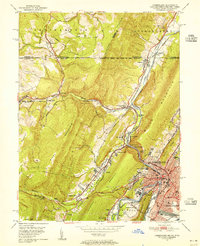
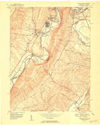
 1948 Cumberland1948 Print · USGSMid-century Appalachia and the Shenandoah Valley are shown in detail, documenting the industrial and transportation hubs of the tri-state area. Genealogists can trace family roots through settlements like Double Tollgate and Bunker Hill or along the Baltimore & Ohio RR.3 unique versions available
 - 1949 Map of Cumberland, 1955 Print
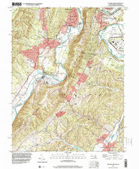
 1949 Cumberland1955 Print · USGSCumberland and the Potomac River valley are shown in detail at mid-century, just as the region's rail and coal infrastructure reached its post-war peak. Local historians can trace the Mason and Dixon Line and locate historic landmarks like Sixmile House and The Narrows.10 unique versions available
 - 1949 Map of Evitts Creek, 1961 Print
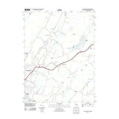
 1949 Evitts Creek1961 Print · USGSThe northern edge of Allegany County meets the Mason and Dixon Line in this late-forties survey. Genealogists and local historians can trace rural family sites like Wolfe Mill, Cooks Mills, and the Union Grove Cem nestled between the ridges.3 unique versions available
 - 1949 Map of Cresaptown, 1966 Print
 1949 Cresaptown1966 Print · USGSThe Potomac River corridor in the late 1940s reveals a landscape of industrial plants and narrow mountain gaps. Researchers can trace family history through the Lease Cem, identify the vanished infrastructure of Amcelle, or locate rural landmarks like Old Furnace Ch and Pinto PO.4 unique versions available
 - 1950 Map of Frostburg, 1960 Print
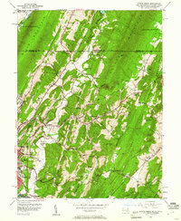
 1950 Frostburg1960 Print · USGSMid-century Allegany County is defined here by its intensive coal mining operations and the intricate rail network of the Western Maryland and other lines. Researchers can trace the lineage of vanished mining hamlets and local landmarks like Borden Shaft, Klondike, and the scenic heights of Lovers Leap.3 unique versions available
 - 1951 Map of Cresaptown
 1951 Cresaptown1951 Print · USGSThe Potomac River borderlands and the ridges of the Appalachians are captured here in the early fifties during a period of heavy rail and industrial activity. Researchers can trace the Chesapeake and Ohio Canal, family burial sites like Frankfort Cem, and the layout of Fort Ashby.
 - 1951 Map of Cumberland
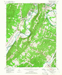
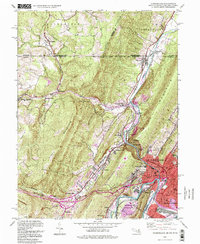
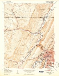 1951 Cumberland1951 Print · USGSThe industrial and rail hub of Cumberland is captured here at mid-century, where the Potomac River meets a complex web of mountain ridges and state lines. Genealogists and local historians can trace family roots through St Patricks Cem, the streets of Mount Savage, or the historic route of the National Pike.3 unique versions available
 - 1951 Map of Evitts Creek
 1951 Evitts Creek1951 Print · USGSMid-century Cumberland and the surrounding Allegany County ridges are captured here as they appeared just after the war. Researchers can locate family landmarks like Zion Ch, trace the old National Pike, or explore the rail yards of the Western Maryland Railway.2 unique versions available
 - 1951 Map of Frostburg, 1966 Print
 1951 Frostburg1966 Print · USGSThe coal and rail corridor of Maryland's Allegany County comes into focus at mid-century, from the heights of Savage Mountain to the Potomac River. Genealogists and historians can trace industrial roots at Borden Shaft, Lonaconing, and Mount Savage.
 - 1952 Map of Cumberland
 1952 Cumberland1952 Print · USGSThe Potomac Highlands and the Shenandoah Valley are revealed in this early 1950s survey of the Appalachian interior. Researchers can trace the river-and-rail corridors connecting Cumberland, Winchester, and the recreational waters of Deep Creek Lake.
 - 1956 Map of Cumberland, 1966 Print
 1956 Cumberland1966 Print · USGSThe tri-state Highlands in the mid-1950s show a landscape shaped by coal, timber, and the massive presence of the Baltimore & Ohio RR. Researchers can trace the industrial corridor from Cumberland through the Allegheny Mountains to mountain retreats like Deep Creek Lake.6 unique versions available
 - 1957 Map of Cumberland
 1957 Cumberland1957 Print · USGSThe Potomac River valley and the ridges of the Allegheny Front define this mid-century landscape at the intersection of Maryland, West Virginia, and Pennsylvania. Trace the steam-era rail lines of the Baltimore and Ohio RR or locate rural landmarks like St Stephens Church and Stony River Dam.
 - 1961 Map of Cumberland
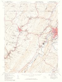
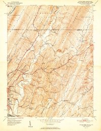
 1961 Cumberland1961 Print · USGSThe tri-state highlands of Maryland, West Virginia, and Pennsylvania are shown in the mid-twentieth century as a complex landscape of ridges and river valleys. Researchers can trace the winding Potomac River and find old rail-and-river towns like Cumberland, Keyser, and Morgantown.
 - 1962 Map of Cumberland
 1962 Cumberland1962 Print · USGSThe central Appalachians meet at the height of the mid-century industrial era, showing the rugged topography between Morgantown and Winchester. Genealogists can trace family lands near Fort Necessity or along the vital Baltimore & Ohio RR corridors.
 - 1977 Map of Cumberland, 1979 Print
 1977 Cumberland1979 Print · USGSWestern Maryland settlements follow the narrow valley floors in the late seventies, clustered around the gap at Cumberland. Trace the residential growth and industrial layouts from Ellerslie to the ridges of Little Allegheny Mountain.
 - 1981 Map of Cumberland, 1982 Print
 1981 Cumberland1982 Print · USGSThe tri-state region of Maryland, Pennsylvania, and West Virginia is captured here in the early eighties as a landscape of industrial history and ridgeline geography. Researchers can trace the heritage of the C & O Canal and the B & O RR through mountain gaps and coal towns like Eckhart Mines and Frostburg.2 unique versions available
 - 1993 Map of Cumberland, 1999 Print
 1993 Cumberland1999 Print · USGSCumberland and the Maryland-Pennsylvania borderlands are captured here in the late twentieth century, showing a landscape shaped by the Mason-Dixon Line and deep mountain gaps. Genealogists and historians can trace the C & O Canal, the grounds of the County Home, and legacy rail lines like the Baltimore and Ohio Railroad.
 - 1997 Map of Cresaptown, 2001 Print
 1997 Cresaptown2001 Print · USGSThe Potomac River valley in the late nineties shows a landscape shaped by transportation and agriculture along the Maryland-West Virginia border. Researchers can trace historic family burial sites like Cecil Cem and remnants of the C & O Canal.
 - 2011 Map of Evitts Creek, 2011 Print
 2011 Evitts Creek2011 Print · USGSCovers Cumberland, including Bowmans Addition, Cooks Mills, and other nearby areas
 - 2011 Map of Cumberland, 2011 Print
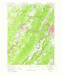
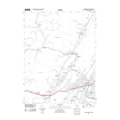 2011 Cumberland2011 Print · USGSCovers Cumberland, including La Vale, Carpendale, and other nearby areas
Showing maps 1-25 of 38
Top cities near Cumberland
- Frostburg historical maps
- Keyser historical maps
- La Vale historical maps
- Bel Air historical maps
- Fairhope Township historical maps
- Lonaconing historical maps
See more
Top neighborhoods of Cumberland
- Cumberland Heights historical maps
- South Cumberland historical maps
- Decatur Heights historical maps
- Downtown historical maps
- North End historical maps
- Olde North End historical maps
See more
Frequently asked questions
- What are the different types of historical maps available for Cumberland?
- What is the oldest map of Cumberland?
- Where can I purchase historical maps of Cumberland for my home or office?
- Where can I download high-res historical maps of Cumberland?
- Are there historical topographic maps available for Cumberland?
- Is there historical aerial imagery available for Cumberland?
- Where are historical maps of Cumberland sourced from?