1950s Maps of Cumberland, Maryland
Explore 8 historic maps of Cumberland from the 1950s. These maps offer a rare glimpse into what life looked like during the 1950s — showing old roads, neighborhoods, homes, and landmarks that have changed or disappeared over time.
Whether you're researching your family's past, planning a metal detecting trip, or studying how Cumberland's landscape evolved across the 1950s, these high-resolution maps are a powerful tool for exploring the history of this region.
- Focus on a specific era: All maps on this page are from the 1950s, giving you a focused view of this time period.
- See what’s changed: Compare century-old streets, trails, and buildings to today's modern landscape using overlays and satellite layers.
- Research with precision: Use these maps for genealogy, historical research, land use analysis, or educational projects.
- View, download, or print: Maps are fully viewable online in high resolution, and can be downloaded or printed for your own records.
Start exploring Cumberland's history through authentic maps from the 1950s. This is your window into the past.
Cumberland, MD maps
(8)- 1950 Map of Frostburg, 1960 Print
 1950 Frostburg1960 Print · USGSMid-century Allegany County is defined here by its intensive coal mining operations and the intricate rail network of the Western Maryland and other lines. Researchers can trace the lineage of vanished mining hamlets and local landmarks like Borden Shaft, Klondike, and the scenic heights of Lovers Leap.3 unique versions available
 - 1951 Map of Cresaptown
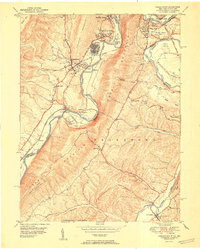 1951 Cresaptown1951 Print · USGSThe Potomac River borderlands and the ridges of the Appalachians are captured here in the early fifties during a period of heavy rail and industrial activity. Researchers can trace the Chesapeake and Ohio Canal, family burial sites like Frankfort Cem, and the layout of Fort Ashby.
 - 1951 Map of Cumberland
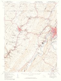
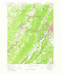
 1951 Cumberland1951 Print · USGSThe industrial and rail hub of Cumberland is captured here at mid-century, where the Potomac River meets a complex web of mountain ridges and state lines. Genealogists and local historians can trace family roots through St Patricks Cem, the streets of Mount Savage, or the historic route of the National Pike.3 unique versions available
 - 1951 Map of Evitts Creek
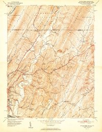 1951 Evitts Creek1951 Print · USGSMid-century Cumberland and the surrounding Allegany County ridges are captured here as they appeared just after the war. Researchers can locate family landmarks like Zion Ch, trace the old National Pike, or explore the rail yards of the Western Maryland Railway.2 unique versions available
 - 1951 Map of Frostburg, 1966 Print
 1951 Frostburg1966 Print · USGSThe coal and rail corridor of Maryland's Allegany County comes into focus at mid-century, from the heights of Savage Mountain to the Potomac River. Genealogists and historians can trace industrial roots at Borden Shaft, Lonaconing, and Mount Savage.
 - 1952 Map of Cumberland
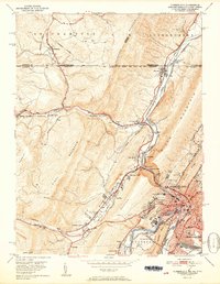
 1952 Cumberland1952 Print · USGSThe Potomac Highlands and the Shenandoah Valley are revealed in this early 1950s survey of the Appalachian interior. Researchers can trace the river-and-rail corridors connecting Cumberland, Winchester, and the recreational waters of Deep Creek Lake.
 - 1956 Map of Cumberland, 1966 Print
 1956 Cumberland1966 Print · USGSThe tri-state Highlands in the mid-1950s show a landscape shaped by coal, timber, and the massive presence of the Baltimore & Ohio RR. Researchers can trace the industrial corridor from Cumberland through the Allegheny Mountains to mountain retreats like Deep Creek Lake.6 unique versions available
 - 1957 Map of Cumberland
 1957 Cumberland1957 Print · USGSThe Potomac River valley and the ridges of the Allegheny Front define this mid-century landscape at the intersection of Maryland, West Virginia, and Pennsylvania. Trace the steam-era rail lines of the Baltimore and Ohio RR or locate rural landmarks like St Stephens Church and Stony River Dam.
End of results
Showing maps 1-8 of 8
Top cities near Cumberland
- Frostburg historical maps
- Keyser historical maps
- La Vale historical maps
- Bel Air historical maps
- Fairhope Township historical maps
- Lonaconing historical maps
See more
Top neighborhoods of Cumberland
- Cumberland Heights historical maps
- South Cumberland historical maps
- Decatur Heights historical maps
- Downtown historical maps
- North End historical maps
- Olde North End historical maps
See more
Frequently asked questions
- What are the different types of historical maps available for Cumberland?
- What is the oldest map of Cumberland?
- Where can I purchase historical maps of Cumberland for my home or office?
- Where can I download high-res historical maps of Cumberland?
- Are there historical topographic maps available for Cumberland?
- Is there historical aerial imagery available for Cumberland?
- Where are historical maps of Cumberland sourced from?