1940s Maps of Spring Meadows, Maryland
Explore 5 historic maps of Spring Meadows from the 1940s. These maps offer a rare glimpse into what life looked like during the 1940s — showing old roads, neighborhoods, homes, and landmarks that have changed or disappeared over time.
Whether you're researching your family's past, planning a metal detecting trip, or studying how Spring Meadows's landscape evolved across the 1940s, these high-resolution maps are a powerful tool for exploring the history of this region.
- Focus on a specific era: All maps on this page are from the 1940s, giving you a focused view of this time period.
- See what’s changed: Compare century-old streets, trails, and buildings to today's modern landscape using overlays and satellite layers.
- Research with precision: Use these maps for genealogy, historical research, land use analysis, or educational projects.
- View, download, or print: Maps are fully viewable online in high resolution, and can be downloaded or printed for your own records.
Start exploring Spring Meadows's history through authentic maps from the 1940s. This is your window into the past.
Spring Meadows, MD maps
(5)- 1944 Map of Odenton
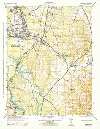 1944 Odenton1944 Print · USGSMid-century Anne Arundel County shows a blend of military activity and rural Maryland life during the war years. Genealogists and researchers can trace old crossroads and community landmarks like Waugh Chapel, the Bowie Race Track, and the US Naval Academy Dairy.2 unique versions available
 - 1946 Map of Odenton
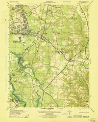 1946 Odenton1946 Print · USGSOdenton and the surrounding Anne Arundel countryside are captured here just after the war, when military expansion and rural crossroads met. Researchers can trace the sprawling Fort George G Meade and locate family landmarks like Waugh Chapel, Severn Crossroads, and the Bowie Race Track.
 - 1947 Map of Relay, 1954 Print
 1947 Relay1954 Print · USGSMid-century Anne Arundel County is caught between its rail-and-river heritage and the rise of the jet age. Genealogists and local historians can trace the footprint of the Baltimore Friendship International Airport or locate family plots in Cedar Hill Cem and Arundel Cem.2 unique versions available
 - 1948 Map of Baltimore
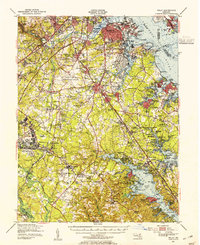
 1948 Baltimore1948 Print · USGSMaryland and Pennsylvania crossroads are captured in the late 1940s, showing a landscape defined by historic rail lines and major military installations. Genealogists can trace family connections in Gettysburg, Westminster, and near the U.S. Naval Academy in Annapolis.2 unique versions available
 - 1949 Map of Odenton, 1953 Print
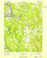 1949 Odenton1953 Print · USGSAnne Arundel County in the post-war era reveals a landscape shaped by military expansion and historic crossroads. Genealogists and local historians can trace family burial sites like Warfield Cem, established schools such as Arundel High Sch, and the unique U S Naval Academy Dairy Farm.
End of results
Showing maps 1-5 of 5
Top cities near Spring Meadows
- Washington historical maps
- Baltimore historical maps
- Columbia historical maps
- Glen Burnie historical maps
- Dundalk historical maps
- Bowie historical maps
See more
Frequently asked questions
- What are the different types of historical maps available for Spring Meadows?
- What is the oldest map of Spring Meadows?
- Where can I purchase historical maps of Spring Meadows for my home or office?
- Where can I download high-res historical maps of Spring Meadows?
- Are there historical topographic maps available for Spring Meadows?
- Is there historical aerial imagery available for Spring Meadows?
- Where are historical maps of Spring Meadows sourced from?