1990s Maps of Spyglass, Maryland
Explore 1 historic maps of Spyglass from the 1990s. These maps offer a rare glimpse into what life looked like during the 1990s — showing old roads, neighborhoods, homes, and landmarks that have changed or disappeared over time.
Whether you're researching your family's past, planning a metal detecting trip, or studying how Spyglass's landscape evolved across the 1990s, these high-resolution maps are a powerful tool for exploring the history of this region.
- Focus on a specific era: All maps on this page are from the 1990s, giving you a focused view of this time period.
- See what’s changed: Compare century-old streets, trails, and buildings to today's modern landscape using overlays and satellite layers.
- Research with precision: Use these maps for genealogy, historical research, land use analysis, or educational projects.
- View, download, or print: Maps are fully viewable online in high resolution, and can be downloaded or printed for your own records.
Start exploring Spyglass's history through authentic maps from the 1990s. This is your window into the past.
Spyglass, MD maps
(1)- 1997 Map of Deale, 1999 Print
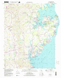 1997 Deale1999 Print · USGSThe western shore of the Chesapeake Bay comes alive in this late-century look at Maryland's tidal creeks and maritime communities. Genealogists and local historians can trace family locations through Galesville, Deale, and Shady Side, or find historic landmarks like West River Church and Deep Creek Airpark.
End of results
Showing maps 1-1 of 1
Top cities near Spyglass
- Bowie historical maps
- Annapolis historical maps
- Crofton historical maps
- Edgewater historical maps
- Mayo historical maps
- Stevensville historical maps
See more
Frequently asked questions
- What are the different types of historical maps available for Spyglass?
- What is the oldest map of Spyglass?
- Where can I purchase historical maps of Spyglass for my home or office?
- Where can I download high-res historical maps of Spyglass?
- Are there historical topographic maps available for Spyglass?
- Is there historical aerial imagery available for Spyglass?
- Where are historical maps of Spyglass sourced from?