1950s Maps of Mich-Trace Estates, Maryland
Explore 4 historic maps of Mich-Trace Estates from the 1950s. These maps offer a rare glimpse into what life looked like during the 1950s — showing old roads, neighborhoods, homes, and landmarks that have changed or disappeared over time.
Whether you're researching your family's past, planning a metal detecting trip, or studying how Mich-Trace Estates's landscape evolved across the 1950s, these high-resolution maps are a powerful tool for exploring the history of this region.
- Focus on a specific era: All maps on this page are from the 1950s, giving you a focused view of this time period.
- See what’s changed: Compare century-old streets, trails, and buildings to today's modern landscape using overlays and satellite layers.
- Research with precision: Use these maps for genealogy, historical research, land use analysis, or educational projects.
- View, download, or print: Maps are fully viewable online in high resolution, and can be downloaded or printed for your own records.
Start exploring Mich-Trace Estates's history through authentic maps from the 1950s. This is your window into the past.
Mich-Trace Estates, MD maps
(4)- 1953 Map of Manchester, 1954 Print
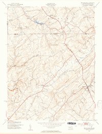 1953 Manchester1954 Print · USGSThe Maryland-Pennsylvania borderlands are captured here in the early fifties, where the historic Mason and Dixon Line bisects a landscape of small farming hamlets. Researchers can trace the layout of old rural crossroads such as Bachman Mills, Bixler, and Melrose.6 unique versions available
 - 1954 Map of Baltimore
 1954 Baltimore1954 Print · USGSThe Mid-Atlantic region in the early fifties shows a landscape of growing suburban centers and heavy rail corridors. Trace mid-century transit networks and military landmarks from the Aberdeen Proving Ground to the Gettysburg National Military Park.
 - 1956 Map of Baltimore
 1956 Baltimore1956 Print · USGSMid-century Maryland and Pennsylvania are captured here during a period of massive suburban and military growth across the Chesapeake region. Genealogists and historians can trace the rail corridors of the Baltimore & Ohio RR and locate landmarks like Fort McHenry or the Aberdeen Proving Ground.
 - 1957 Map of Baltimore, 1964 Print
 1957 Baltimore1964 Print · USGSMaryland and Southern Pennsylvania are shown during the mid-century expansion of the Baltimore-Washington corridor. Researchers can trace the extensive rail lines of the Baltimore & Ohio RR and locate sites like Fort Detrick and Gettysburg National Military Park.5 unique versions available
End of results
Showing maps 1-4 of 4
Top cities near Mich-Trace Estates
- Westminster historical maps
- Hanover historical maps
- Parkville historical maps
- West Manheim Township historical maps
- Taneytown historical maps
- Hampstead historical maps
See more
Frequently asked questions
- What are the different types of historical maps available for Mich-Trace Estates?
- What is the oldest map of Mich-Trace Estates?
- Where can I purchase historical maps of Mich-Trace Estates for my home or office?
- Where can I download high-res historical maps of Mich-Trace Estates?
- Are there historical topographic maps available for Mich-Trace Estates?
- Is there historical aerial imagery available for Mich-Trace Estates?
- Where are historical maps of Mich-Trace Estates sourced from?