1910s Maps of Bowen Estates, Maryland
Explore 2 historic maps of Bowen Estates from the 1910s. These maps offer a rare glimpse into what life looked like during the 1910s — showing old roads, neighborhoods, homes, and landmarks that have changed or disappeared over time.
Whether you're researching your family's past, planning a metal detecting trip, or studying how Bowen Estates's landscape evolved across the 1910s, these high-resolution maps are a powerful tool for exploring the history of this region.
- Focus on a specific era: All maps on this page are from the 1910s, giving you a focused view of this time period.
- See what’s changed: Compare century-old streets, trails, and buildings to today's modern landscape using overlays and satellite layers.
- Research with precision: Use these maps for genealogy, historical research, land use analysis, or educational projects.
- View, download, or print: Maps are fully viewable online in high resolution, and can be downloaded or printed for your own records.
Start exploring Bowen Estates's history through authentic maps from the 1910s. This is your window into the past.
Bowen Estates, MD maps
(2)- 1911 Map of Brandywine, 1962 Print
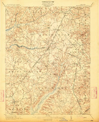
 1911 Brandywine1962 Print · USGSSouthern Maryland at the turn of the century shows a landscape of rail-connected farming towns and expansive wetlands. Researchers can trace ancestral locations near LA PLATA, the old Reform School, or country parishes like St Peters Church and Piney Church.
 - 1913 Map of Brandywine
 1913 Brandywine1913 Print · USGSSouthern Maryland at the turn of the century shows a landscape transitioning through early rail and rural growth. Genealogists can trace family roots through landmarks like St Peters Church, Winkler Shop School, and old stops such as Malcolm Woodville Station.3 unique versions available
End of results
Showing maps 1-2 of 2
Top cities near Bowen Estates
- Washington historical maps
- Waldorf historical maps
- Clinton historical maps
- Camp Springs historical maps
- Westphalia historical maps
- Rosaryville historical maps
See more
Frequently asked questions
- What are the different types of historical maps available for Bowen Estates?
- What is the oldest map of Bowen Estates?
- Where can I purchase historical maps of Bowen Estates for my home or office?
- Where can I download high-res historical maps of Bowen Estates?
- Are there historical topographic maps available for Bowen Estates?
- Is there historical aerial imagery available for Bowen Estates?
- Where are historical maps of Bowen Estates sourced from?