1950s Maps of Indian Head, Maryland
Explore 4 historic maps of Indian Head from the 1950s. These maps offer a rare glimpse into what life looked like during the 1950s — showing old roads, neighborhoods, homes, and landmarks that have changed or disappeared over time.
Whether you're researching your family's past, planning a metal detecting trip, or studying how Indian Head's landscape evolved across the 1950s, these high-resolution maps are a powerful tool for exploring the history of this region.
- Focus on a specific era: All maps on this page are from the 1950s, giving you a focused view of this time period.
- See what’s changed: Compare century-old streets, trails, and buildings to today's modern landscape using overlays and satellite layers.
- Research with precision: Use these maps for genealogy, historical research, land use analysis, or educational projects.
- View, download, or print: Maps are fully viewable online in high resolution, and can be downloaded or printed for your own records.
Start exploring Indian Head's history through authentic maps from the 1950s. This is your window into the past.
Indian Head, MD maps
(4)- 1951 Map of Indian Head, 1954 Print
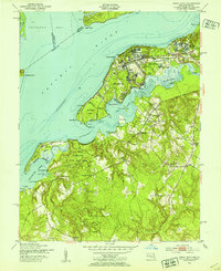 1951 Indian Head1954 Print · USGSCharles County's riverfront was defined by defense and tidal waters in the early fifties as the US Naval Reservation expanded. Genealogists can trace family landmarks and rural life through St Charles Ch, Alexandria Cem, and several historic landings like Mattingly Wharf.2 unique versions available
 - 1956 Map of Indian Head, 1959 Print
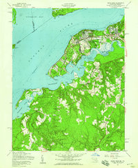 1956 Indian Head1959 Print · USGSMaryland's military and maritime heritage is on full display here during the mid-fifties as the Indian Head Powder Factory and U S Naval Reservation expand. Genealogists can locate several historic country churches including St Marys Ch and Alexandria Chapel, alongside landing sites like Poseys Wharf.
 - 1956 Map of Indian Head, 1961 Print
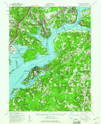 1956 Indian Head1961 Print · USGSThe Potomac shoreline in the mid-fifties is a landscape of federal reservations and tobacco-country heritage. Researchers can trace historic river landings like Proctors Wharf and significant sites such as the Indian Head Powder Factory or the Habre de Venture estate.2 unique versions available
 - 1957 Map of Washington, 1966 Print
 1957 Washington1966 Print · USGSThe mid-Atlantic region during the mid-fifties and early sixties reveals a landscape of growing suburbs and vital military outposts. Researchers can trace historic river towns and shorelines from Alexandria to the Hooper Islands and St Clements Island.5 unique versions available
End of results
Showing maps 1-4 of 4
Top cities near Indian Head
- Washington historical maps
- Alexandria historical maps
- Dale City historical maps
- Lake Ridge historical maps
- Woodbridge historical maps
- Burke historical maps
See more
Top neighborhoods of Indian Head
- Potomac Wood historical maps
- Perry Wright historical maps
- Mattawoman Woods historical maps
- Warington Hills historical maps
Frequently asked questions
- What are the different types of historical maps available for Indian Head?
- What is the oldest map of Indian Head?
- Where can I purchase historical maps of Indian Head for my home or office?
- Where can I download high-res historical maps of Indian Head?
- Are there historical topographic maps available for Indian Head?
- Is there historical aerial imagery available for Indian Head?
- Where are historical maps of Indian Head sourced from?