1910s Maps of Preference Estates, Maryland
Explore 2 historic maps of Preference Estates from the 1910s. These maps offer a rare glimpse into what life looked like during the 1910s — showing old roads, neighborhoods, homes, and landmarks that have changed or disappeared over time.
Whether you're researching your family's past, planning a metal detecting trip, or studying how Preference Estates's landscape evolved across the 1910s, these high-resolution maps are a powerful tool for exploring the history of this region.
- Focus on a specific era: All maps on this page are from the 1910s, giving you a focused view of this time period.
- See what’s changed: Compare century-old streets, trails, and buildings to today's modern landscape using overlays and satellite layers.
- Research with precision: Use these maps for genealogy, historical research, land use analysis, or educational projects.
- View, download, or print: Maps are fully viewable online in high resolution, and can be downloaded or printed for your own records.
Start exploring Preference Estates's history through authentic maps from the 1910s. This is your window into the past.
Preference Estates, MD maps
(2)- 1911 Map of Wicomico, 1961 Print
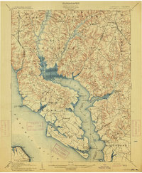
 1911 Wicomico1961 Print · USGSSouthern Maryland's river-dependent landscape is documented here during the early twentieth century, showing the tidewater border of Charles and St Marys counties. Genealogists can trace family-named points and wharves like Lancaster Wharf, the Laidlow Ferry, and the rail terminus at Popes Creek.
 - 1914 Map of Wicomico
 1914 Wicomico1914 Print · USGSSouthern Maryland's riverfront life is captured here during the early twentieth century, showing a landscape of tidal creeks and busy steamboat landings. Genealogists can trace family footprints near Charlotte Hall, find old crossings like Ludlow Ferry, or locate historic maritime hubs like Bushwood Wharf.4 unique versions available
End of results
Showing maps 1-2 of 2
Top cities near Preference Estates
- Waldorf historical maps
- Lorton historical maps
- Bennsville historical maps
- Accokeek historical maps
- Mount Vernon historical maps
- Brandywine historical maps
See more
Frequently asked questions
- What are the different types of historical maps available for Preference Estates?
- What is the oldest map of Preference Estates?
- Where can I purchase historical maps of Preference Estates for my home or office?
- Where can I download high-res historical maps of Preference Estates?
- Are there historical topographic maps available for Preference Estates?
- Is there historical aerial imagery available for Preference Estates?
- Where are historical maps of Preference Estates sourced from?