1980s Maps of Bestpitch, Maryland
Explore 2 historic maps of Bestpitch from the 1980s. These maps offer a rare glimpse into what life looked like during the 1980s — showing old roads, neighborhoods, homes, and landmarks that have changed or disappeared over time.
Whether you're researching your family's past, planning a metal detecting trip, or studying how Bestpitch's landscape evolved across the 1980s, these high-resolution maps are a powerful tool for exploring the history of this region.
- Focus on a specific era: All maps on this page are from the 1980s, giving you a focused view of this time period.
- See what’s changed: Compare century-old streets, trails, and buildings to today's modern landscape using overlays and satellite layers.
- Research with precision: Use these maps for genealogy, historical research, land use analysis, or educational projects.
- View, download, or print: Maps are fully viewable online in high resolution, and can be downloaded or printed for your own records.
Start exploring Bestpitch's history through authentic maps from the 1980s. This is your window into the past.
Bestpitch, MD maps
(2)- 1982 Map of Chicamacomico River, 1983 Print
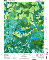 1982 Chicamacomico River1983 Print · USGSDorchester County's intricate shoreline and tidal marshes are captured here in the late seventies, showing a landscape defined by the Chicamacomico River. Researchers can locate family landmarks like Eagle Hall and Griffith Neck, or trace old landings at Cedar Landing and Brick House Landing.2 unique versions available
 - 1983 Map of Salisbury, 1984 Print
 1983 Salisbury1984 Print · USGSThe Lower Eastern Shore was a landscape of tide and timber in the early eighties, from the bustling streets of Salisbury to the wild coast of Assateague Island. Researchers can trace the rail-and-road network of the Conrail and U S Highway 50 while locating historic centers like Princess Anne and Crisfield.
End of results
Showing maps 1-2 of 2
Top cities near Bestpitch
- Cambridge historical maps
- Hurlock historical maps
- Secretary historical maps
- Vienna historical maps
- East New Market historical maps
- Church Creek historical maps
See more
Frequently asked questions
- What are the different types of historical maps available for Bestpitch?
- What is the oldest map of Bestpitch?
- Where can I purchase historical maps of Bestpitch for my home or office?
- Where can I download high-res historical maps of Bestpitch?
- Are there historical topographic maps available for Bestpitch?
- Is there historical aerial imagery available for Bestpitch?
- Where are historical maps of Bestpitch sourced from?