1940s Maps of Kingsbrook, Frederick County
Explore 4 historic maps of Kingsbrook from the 1940s. These maps offer a rare glimpse into what life looked like during the 1940s — showing old roads, neighborhoods, homes, and landmarks that have changed or disappeared over time.
Whether you're researching your family's past, planning a metal detecting trip, or studying how Kingsbrook's landscape evolved across the 1940s, these high-resolution maps are a powerful tool for exploring the history of this region.
- Focus on a specific era: All maps on this page are from the 1940s, giving you a focused view of this time period.
- See what’s changed: Compare century-old streets, trails, and buildings to today's modern landscape using overlays and satellite layers.
- Research with precision: Use these maps for genealogy, historical research, land use analysis, or educational projects.
- View, download, or print: Maps are fully viewable online in high resolution, and can be downloaded or printed for your own records.
Start exploring Kingsbrook's history through authentic maps from the 1940s. This is your window into the past.
Kingsbrook, Frederick County maps
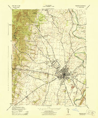
(4)- 1942 Map of Frederick
 1942 Frederick1942 Print · USGSMid-century Maryland's central corridor is centered on Frederick as it appeared before the modern interstate system. Researchers can trace the routes of the B & O Canal, locate the Montevue Almshouse, and see the intersection of the Northern Central RR with early turnpikes.
 - 1944 Map of Buckeystown
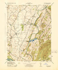 1944 Buckeystown1944 Print · USGSMid-century Frederick County comes alive through its rail-side hamlets and riverside mills during the 1940s. Genealogists and historians can trace the foundations of Buckeystown, locate the Buckingham School Orphanage, and follow the Baltimore and Ohio tracks through Adamstown.
 - 1944 Map of Frederick
 1944 Frederick1944 Print · USGSMaryland's Piedmont region during the 1940s reveals a landscape of industrial growth and mountain recreation. Researchers can trace historic transport lines through Montevue Sta, the Frederick Airport, and the large Mt Olivet Cemetery.
 - 1948 Map of Baltimore
 1948 Baltimore1948 Print · USGSMaryland and Pennsylvania crossroads are captured in the late 1940s, showing a landscape defined by historic rail lines and major military installations. Genealogists can trace family connections in Gettysburg, Westminster, and near the U.S. Naval Academy in Annapolis.2 unique versions available
End of results
Showing maps 1-4 of 4
Frequently asked questions
- What are the different types of historical maps available for Kingsbrook?
- What is the oldest map of Kingsbrook?
- Where can I purchase historical maps of Kingsbrook for my home or office?
- Where can I download high-res historical maps of Kingsbrook?
- Are there historical topographic maps available for Kingsbrook?
- Is there historical aerial imagery available for Kingsbrook?
- Where are historical maps of Kingsbrook sourced from?