1940s Maps of Crellin, Maryland
Explore 2 historic maps of Crellin from the 1940s. These maps offer a rare glimpse into what life looked like during the 1940s — showing old roads, neighborhoods, homes, and landmarks that have changed or disappeared over time.
Whether you're researching your family's past, planning a metal detecting trip, or studying how Crellin's landscape evolved across the 1940s, these high-resolution maps are a powerful tool for exploring the history of this region.
- Focus on a specific era: All maps on this page are from the 1940s, giving you a focused view of this time period.
- See what’s changed: Compare century-old streets, trails, and buildings to today's modern landscape using overlays and satellite layers.
- Research with precision: Use these maps for genealogy, historical research, land use analysis, or educational projects.
- View, download, or print: Maps are fully viewable online in high resolution, and can be downloaded or printed for your own records.
Start exploring Crellin's history through authentic maps from the 1940s. This is your window into the past.
Crellin, MD maps
(2)- 1948 Map of Cumberland
 1948 Cumberland1948 Print · USGSMid-century Appalachia and the Shenandoah Valley are shown in detail, documenting the industrial and transportation hubs of the tri-state area. Genealogists can trace family roots through settlements like Double Tollgate and Bunker Hill or along the Baltimore & Ohio RR.3 unique versions available
 - 1948 Map of Oakland, 1958 Print
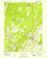 1948 Oakland1958 Print · USGSGarrett County's mountain economy is on full display in the late 1940s, centered on the Youghiogheny River and the Baltimore and Ohio R R. Genealogists and local historians can trace the footprint of Oakland, the rural Sines Cem, and the industrial rail town of Crellin.3 unique versions available
End of results
Showing maps 1-2 of 2
Top cities near Crellin
- Kingwood historical maps
- Mountain Lake Park historical maps
- Oakland historical maps
- Terra Alta historical maps
- Rowlesburg historical maps
- Loch Lynn Heights historical maps
See more
Frequently asked questions
- What are the different types of historical maps available for Crellin?
- What is the oldest map of Crellin?
- Where can I purchase historical maps of Crellin for my home or office?
- Where can I download high-res historical maps of Crellin?
- Are there historical topographic maps available for Crellin?
- Is there historical aerial imagery available for Crellin?
- Where are historical maps of Crellin sourced from?