1940s Maps of Aberdeen, Maryland
Explore 5 historic maps of Aberdeen from the 1940s. These maps offer a rare glimpse into what life looked like during the 1940s — showing old roads, neighborhoods, homes, and landmarks that have changed or disappeared over time.
Whether you're researching your family's past, planning a metal detecting trip, or studying how Aberdeen's landscape evolved across the 1940s, these high-resolution maps are a powerful tool for exploring the history of this region.
- Focus on a specific era: All maps on this page are from the 1940s, giving you a focused view of this time period.
- See what’s changed: Compare century-old streets, trails, and buildings to today's modern landscape using overlays and satellite layers.
- Research with precision: Use these maps for genealogy, historical research, land use analysis, or educational projects.
- View, download, or print: Maps are fully viewable online in high resolution, and can be downloaded or printed for your own records.
Start exploring Aberdeen's history through authentic maps from the 1940s. This is your window into the past.
Aberdeen, MD maps
(5)- 1942 Map of Havre De Grace
 1942 Havre De Grace1942 Print · USGSThe Susquehanna riverfront and Mason-Dixon borderlands are captured here in the early 1940s, just as modern infrastructure began to reshape the region. Genealogists can trace family roots through landmarks like Smith Chapel, Lees Mill, and the Brookview Cem near Rising Sun.4 unique versions available
 - 1944 Map of Perryman
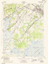 1944 Perryman1944 Print · USGSHarford County's coastal and military landscape is captured here during the height of the Second World War. Genealogists and historians can trace the intersection of family homesteads and military expansion near Perryman, the Harford Furnace School, and Spesutie Church.
 - 1948 Map of Baltimore
 1948 Baltimore1948 Print · USGSMaryland and Pennsylvania crossroads are captured in the late 1940s, showing a landscape defined by historic rail lines and major military installations. Genealogists can trace family connections in Gettysburg, Westminster, and near the U.S. Naval Academy in Annapolis.2 unique versions available
 - 1948 Map of Perryman
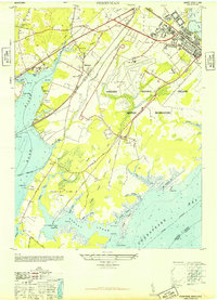 1948 Perryman1948 Print · USGSHarford County is captured in the late 1940s as military expansion reshapes the Chesapeake shoreline. Genealogists and historians can trace the foundations of Old Baltimore, the historic Spesutie Church, and the rural community of Perryman before modern suburban growth.5 unique versions available
 - 1949 Map of Perryman
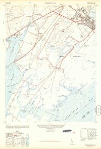 1949 Perryman1949 Print · USGSHarford County's coastal military and rail corridors are captured in detail just after the Second World War. Researchers can trace the layout of the Aberdeen Proving Ground, locate the historic Spesutie Church, and find the site of Old Baltimore along the Bush River.
End of results
Showing maps 1-5 of 5
Top cities near Aberdeen
- Edgewood historical maps
- Forest Hill historical maps
- Havre de Grace historical maps
- Bel Air historical maps
- Perryville historical maps
- Little Britain Township historical maps
See more
Top neighborhoods of Aberdeen
- Hillside historical maps
- Aberdeen Hills historical maps
- Maxa Woods historical maps
- Baldwin Manor historical maps
- North Deen historical maps
- Hamilton Court historical maps
See more
Frequently asked questions
- What are the different types of historical maps available for Aberdeen?
- What is the oldest map of Aberdeen?
- Where can I purchase historical maps of Aberdeen for my home or office?
- Where can I download high-res historical maps of Aberdeen?
- Are there historical topographic maps available for Aberdeen?
- Is there historical aerial imagery available for Aberdeen?
- Where are historical maps of Aberdeen sourced from?