1900s (20th Century) Maps of Baden, Maryland
Explore 11 historic maps of Baden from the 1900s (20th Century). These maps offer a rare glimpse into what life looked like during the 1900s — showing old roads, neighborhoods, homes, and landmarks that have changed or disappeared over time.
Whether you're researching your family's past, planning a metal detecting trip, or studying how Baden's landscape evolved across the 1900s, these high-resolution maps are a powerful tool for exploring the history of this region.
- Focus on a specific era: All maps on this page are from the 1900s, giving you a focused view of this time period.
- See what’s changed: Compare century-old streets, trails, and buildings to today's modern landscape using overlays and satellite layers.
- Research with precision: Use these maps for genealogy, historical research, land use analysis, or educational projects.
- View, download, or print: Maps are fully viewable online in high resolution, and can be downloaded or printed for your own records.
Start exploring Baden's history through authentic maps from the 1900s. This is your window into the past.
Baden, MD maps
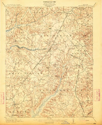
(11)- 1906 Map of Patuxent
 1906 Patuxent1906 Print · USGSThe Tidewater region of Maryland and the outskirts of the District of Columbia are shown here at the turn of the century. Researchers can trace the early footprints of Maryland Agril. College, find riverfront infrastructure at Milltown Landing, and follow long-established routes like the Marlboro Turnpike.4 unique versions available
 - 1911 Map of Brandywine, 1962 Print
 1911 Brandywine1962 Print · USGSSouthern Maryland at the turn of the century shows a landscape of rail-connected farming towns and expansive wetlands. Researchers can trace ancestral locations near LA PLATA, the old Reform School, or country parishes like St Peters Church and Piney Church.
 - 1913 Map of Brandywine
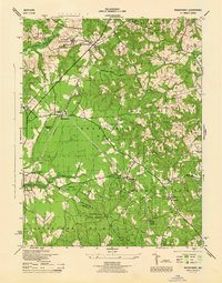
 1913 Brandywine1913 Print · USGSSouthern Maryland at the turn of the century shows a landscape transitioning through early rail and rural growth. Genealogists can trace family roots through landmarks like St Peters Church, Winkler Shop School, and old stops such as Malcolm Woodville Station.3 unique versions available
 - 1944 Map of Brandywine
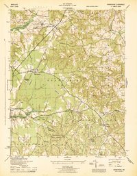
 1944 Brandywine1944 Print · USGSMid-century Southern Maryland comes into focus here, showing the rural crossroads of Prince George's and Charles counties as military and institutional land use expanded. Researchers can trace family-named landmarks and local hubs like Horsehead, Cheltenham School for Boys, and St Michaels Ch.
 - 1945 Map of Brandywine
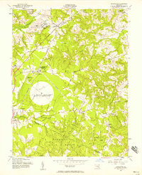
 1945 Brandywine1945 Print · USGSSouthern Prince George's County at the end of the war shows a landscape of rural parishes and state-protected woodlands. Genealogists and researchers can locate family sites near Cheltenham Church, the Cedarville Sch, and the old rail line at Brandywine.
 - 1948 Map of Washington
 1948 Washington1948 Print · USGSThe Potomac and Chesapeake regions in the late 1940s reveal a landscape of expanding military reach and deep-rooted Tidewater settlements. Trace old rail corridors like the Richmond Fredericksburg & Potomac RR or locate landmarks like the Wakefield Washington Monument and St. Marys College.2 unique versions available
 - 1956 Map of Brandywine, 1958 Print
 1956 Brandywine1958 Print · USGSSouthern Maryland in the mid-1950s shows a landscape of small crossroads communities and growing federal installations. Genealogists and historians can trace family roots through the network of local sites like St Thomas Church, Cheltenham, and the Boys Village of Maryland.4 unique versions available
 - 1957 Map of Washington, 1966 Print
 1957 Washington1966 Print · USGSThe mid-Atlantic region during the mid-fifties and early sixties reveals a landscape of growing suburbs and vital military outposts. Researchers can trace historic river towns and shorelines from Alexandria to the Hooper Islands and St Clements Island.5 unique versions available
 - 1961 Map of Washington
 1961 Washington1961 Print · USGSThe mid-Atlantic region in the late fifties is presented in remarkable detail, from the Blue Ridge foothills to the Chesapeake Eastern Shore. Researchers can trace historic river landings and military sites like Mount Vernon, Fort Belvoir, and Point Lookout.2 unique versions available
 - 1983 Map of Washington East, 1984 Print
 1983 Washington East1984 Print · USGSThe Chesapeake Bay region in the early eighties shows the Maryland capital and its suburbs meeting the maritime traditions of the Eastern Shore. Researchers can trace land patterns from Andrews Air Force Base to waterfront settlements like Oxford and Chesapeake Beach.2 unique versions available
 - 1989 Map of Washington
 1989 Washington1989 Print · USGSThe Potomac River valley and Chesapeake Bay are shown in comprehensive detail during the late 1980s. Genealogists and historians can trace the transition from urban Alexandria to the rural Northern Neck, locating landmarks like Mount Vernon and Stratford Hall.
End of results
Showing maps 1-11 of 11
Top cities near Baden
- Washington historical maps
- Waldorf historical maps
- Clinton historical maps
- Suitland historical maps
- Fort Washington historical maps
- Camp Springs historical maps
See more
Frequently asked questions
- What are the different types of historical maps available for Baden?
- What is the oldest map of Baden?
- Where can I purchase historical maps of Baden for my home or office?
- Where can I download high-res historical maps of Baden?
- Are there historical topographic maps available for Baden?
- Is there historical aerial imagery available for Baden?
- Where are historical maps of Baden sourced from?