1960s Maps of Laurel, Maryland
Explore 3 historic maps of Laurel from the 1960s. These maps offer a rare glimpse into what life looked like during the 1960s — showing old roads, neighborhoods, homes, and landmarks that have changed or disappeared over time.
Whether you're researching your family's past, planning a metal detecting trip, or studying how Laurel's landscape evolved across the 1960s, these high-resolution maps are a powerful tool for exploring the history of this region.
- Focus on a specific era: All maps on this page are from the 1960s, giving you a focused view of this time period.
- See what’s changed: Compare century-old streets, trails, and buildings to today's modern landscape using overlays and satellite layers.
- Research with precision: Use these maps for genealogy, historical research, land use analysis, or educational projects.
- View, download, or print: Maps are fully viewable online in high resolution, and can be downloaded or printed for your own records.
Start exploring Laurel's history through authentic maps from the 1960s. This is your window into the past.
Laurel, MD maps
(3)- 1961 Map of Baltimore
 1961 Baltimore1961 Print · USGSMaryland and Pennsylvania are captured at a mid-century peak of industrial and military expansion. Genealogists and historians can trace rail corridors like the Western Maryland Ry or locate regional landmarks such as Camp Detrick and Kent Island.
 - 1964 Map of Beltsville, 1966 Print
 1964 Beltsville1966 Print · USGSMaryland's suburban boundary is frozen in time during the mid-sixties as research farms and military laboratories meet new residential streets. Researchers can trace family roots through Union Cem and Carver Memorial Cemetery or locate landmarks like the Ammendale Normal Institute.5 unique versions available
 - 1965 Map of Laurel, 1966 Print
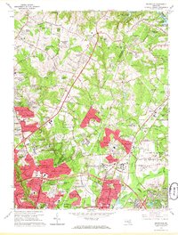
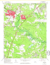 1965 Laurel1966 Print · USGSMaryland during the mid-sixties transition shows a landscape of federal expansion and established local identity. Trace the development of Laurel and Bowie alongside major institutions like the National Security Agency and Bowie State College.4 unique versions available
End of results
Showing maps 1-3 of 3
Top cities near Laurel
- Washington historical maps
- Arlington historical maps
- Columbia historical maps
- Silver Spring historical maps
- Bethesda historical maps
- Bowie historical maps
See more
Top neighborhoods of Laurel
- Laurel Oaks historical maps
- Scotchtown Hills historical maps
- Steward Manor historical maps
- Carriage Hill historical maps
- Stonewood historical maps
- The Dona Apartments historical maps
Frequently asked questions
- What are the different types of historical maps available for Laurel?
- What is the oldest map of Laurel?
- Where can I purchase historical maps of Laurel for my home or office?
- Where can I download high-res historical maps of Laurel?
- Are there historical topographic maps available for Laurel?
- Is there historical aerial imagery available for Laurel?
- Where are historical maps of Laurel sourced from?