1900-1909 Maps of Char-Nor Manor, Maryland
Explore 2 historic maps of Char-Nor Manor from 1900-1909. These maps offer a rare glimpse into what life looked like during the 1900s — showing old roads, neighborhoods, homes, and landmarks that have changed or disappeared over time.
Whether you're researching your family's past, planning a metal detecting trip, or studying how Char-Nor Manor's landscape evolved across the 1900s, these high-resolution maps are a powerful tool for exploring the history of this region.
- Focus on a specific era: All maps on this page are from the 1900s, giving you a focused view of this time period.
- See what’s changed: Compare century-old streets, trails, and buildings to today's modern landscape using overlays and satellite layers.
- Research with precision: Use these maps for genealogy, historical research, land use analysis, or educational projects.
- View, download, or print: Maps are fully viewable online in high resolution, and can be downloaded or printed for your own records.
Start exploring Char-Nor Manor's history through authentic maps from the 1900s. This is your window into the past.
Char-Nor Manor, MD maps
(2)- 1905 Map of Barclay
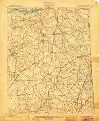 1905 Barclay1905 Print · USGSUpper Delmarva at the start of the twentieth century was a landscape of rail-connected farming towns and river landings. Trace family roots and old property lines near Sudlersville, the Ashland Hayden P O, and the Benedictine Convent.3 unique versions available
 - 1906 Map of Dover
 1906 Dover1906 Print · USGSCentral Delaware and Maryland's Eastern Shore appear at the start of the twentieth century, focused on the bustling rail-and-river economy. Genealogists can trace old family landing sites and crossroads villages like Bohemia Mills, Deakyneville Ldg., and Seven Hickories.3 unique versions available
End of results
Showing maps 1-2 of 2
Top cities near Char-Nor Manor
- Middletown historical maps
- Chestertown historical maps
- Centreville historical maps
- Kingstown historical maps
- Cecilton historical maps
- Church Hill historical maps
See more
Frequently asked questions
- What are the different types of historical maps available for Char-Nor Manor?
- What is the oldest map of Char-Nor Manor?
- Where can I purchase historical maps of Char-Nor Manor for my home or office?
- Where can I download high-res historical maps of Char-Nor Manor?
- Are there historical topographic maps available for Char-Nor Manor?
- Is there historical aerial imagery available for Char-Nor Manor?
- Where are historical maps of Char-Nor Manor sourced from?