1940s Maps of Romancoke, Maryland
Explore 3 historic maps of Romancoke from the 1940s. These maps offer a rare glimpse into what life looked like during the 1940s — showing old roads, neighborhoods, homes, and landmarks that have changed or disappeared over time.
Whether you're researching your family's past, planning a metal detecting trip, or studying how Romancoke's landscape evolved across the 1940s, these high-resolution maps are a powerful tool for exploring the history of this region.
- Focus on a specific era: All maps on this page are from the 1940s, giving you a focused view of this time period.
- See what’s changed: Compare century-old streets, trails, and buildings to today's modern landscape using overlays and satellite layers.
- Research with precision: Use these maps for genealogy, historical research, land use analysis, or educational projects.
- View, download, or print: Maps are fully viewable online in high resolution, and can be downloaded or printed for your own records.
Start exploring Romancoke's history through authentic maps from the 1940s. This is your window into the past.
Romancoke, MD maps
(3)- 1942 Map of Kent Island, 1961 Print
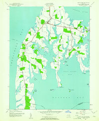 1942 Kent Island1961 Print · USGSKent Island at the onset of the 1940s remained a landscape of ferry landings and rail terminals along the Chesapeake. Genealogists and local historians can trace family locations near Batts Neck Sch, Stevensville, and the Baltimore and Eastern RR line.3 unique versions available
 - 1943 Map of Kent Island
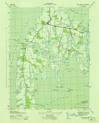 1943 Kent Island1943 Print · USGSKent Island was a vital Chesapeake transit hub during the 1940s, serving as the eastern terminus for the Annapolis-Matapeake Ferry. Trace old rail lines like the Baltimore and Eastern and find community landmarks like Wesley Church and Batts Neck School.
 - 1948 Map of Washington
 1948 Washington1948 Print · USGSThe Potomac and Chesapeake regions in the late 1940s reveal a landscape of expanding military reach and deep-rooted Tidewater settlements. Trace old rail corridors like the Richmond Fredericksburg & Potomac RR or locate landmarks like the Wakefield Washington Monument and St. Marys College.2 unique versions available
End of results
Showing maps 1-3 of 3
Top cities near Romancoke
- Severna Park historical maps
- Annapolis historical maps
- Arnold historical maps
- Easton historical maps
- Edgewater historical maps
- Mayo historical maps
See more
Frequently asked questions
- What are the different types of historical maps available for Romancoke?
- What is the oldest map of Romancoke?
- Where can I purchase historical maps of Romancoke for my home or office?
- Where can I download high-res historical maps of Romancoke?
- Are there historical topographic maps available for Romancoke?
- Is there historical aerial imagery available for Romancoke?
- Where are historical maps of Romancoke sourced from?