Old Maps of Dennis, Massachusetts for Academic Research
Study the evolution of Dennis with these high-resolution historic maps. Whether you're teaching, researching, or modeling changes in land use, these maps provide essential visual documentation of urban, environmental, and geographic change.
- Analyze long-term change: Track patterns in development, transportation, and natural features.
- Ideal for environmental or urban studies: Support academic projects with primary historical map data.
- Use in the classroom or lab: Educators and researchers rely on these maps to bring historical context to life.
These maps are a powerful tool for teaching, research, and visualizing how Dennis has changed over the decades.
Dennis, MA maps
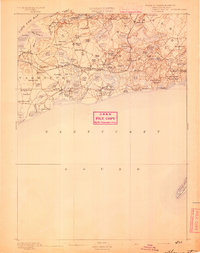
- 1887 Map of Wellfleet
 1887 Wellfleet1887 Print · USGSThe lower Cape comes into focus during the late nineteenth and early twentieth centuries as the railroad reshapes coastal commerce. Genealogists and historians can trace family locations near the Methodist Camp Ground, Mayo's Beach Light, and the Marconi Towers.
 - 1887 Map of Yarmouth
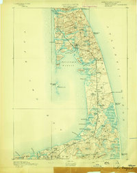
 1887 Yarmouth1887 Print · USGSMid-Cape Cod comes to life in the late nineteenth century as the rail network expands through established maritime villages. Genealogists can trace family footprints across South Yarmouth, West Dennis, and Harwich Port, or locate landmarks like Bass River Lt. and Scargo Hill.
 - 1888 Map of Barnstable
 1888 Barnstable1888 Print · USGSMid-Cape Cod in the late nineteenth century was defined by its maritime commerce and the arrival of the rail. Genealogists and historians can trace the foundations of local life at the Indian Meeting House, Marston's Mills, and the Old Colony Railroad.
 - 1889 Map of Yarmouth
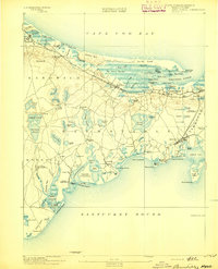
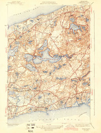
 1889 Yarmouth1889 Print · USGSMid-Cape Cod comes to life in the late 1880s as the rail network reshapes the maritime landscape. Genealogists and historians can trace the early rail stops along the Old Colony Railroad and locate vanished landmarks like the Town House or the historic harbor at Dennis Port.
 - 1889 Map of Wellfleet
 1889 Wellfleet1889 Print · USGSThe Lower Cape is shown here in the late nineteenth century as a vital maritime and railroad corridor. Genealogists and historians can trace the early rail stops and shoreline landmarks like the Methodist Camp Ground and the Billingsgate Light.
 - 1893 Map of Yarmouth
 1893 Yarmouth1893 Print · USGSMid-Cape Cod in the late nineteenth century is a landscape of thriving maritime villages and a busy rail network. Trace nineteenth-century family roots across Old Colony Railroad depots and through settlements like South Yarmouth, Dennis Port, and West Brewster.7 unique versions available
 - 1893 Map of Wellfleet
 1893 Wellfleet1893 Print · USGSCape Cod's outer reaches are shown in the late 1800s, when the Old Colony Railroad served isolated fishing villages and lifesaving stations. Trace historic sites like the Methodist Camp Ground, Billingsgate Light, and early schools at Schoolhouse Pond.8 unique versions available
 - 1893 Map of Barnstable
 1893 Barnstable1893 Print · USGSCape Cod in the late nineteenth century remains a landscape of maritime navigation and early rail travel. Genealogists can trace family roots through sites like the Indian Meeting House, the Yarmouth Camp Grounds, and the Spring Hill Academy.8 unique versions available
 - 1942 Map of Cape Cod Bay
 1942 Cape Cod Bay1942 Print · USGSThe mid-Cape and Outer Cape regions are shown here during the early war years, documenting a landscape of coastal villages and maritime trade. Researchers can trace family roots through old settlements like South Truro, find the grounds of Camp Edwards, or locate historic aids like Sandy Neck Light.
 - 1943 Map of Dennis
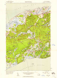
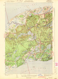 1943 Dennis1943 Print · USGSMid-Cape Cod during the early war years remains a landscape of quiet coastal villages and sprawling kettle ponds. Researchers can trace the old New York New Haven and Hartford rail line to Bass River Sta or locate family plots in Howes Cem and Swan Pond Cem.3 unique versions available
 - 1943 Map of Harwich
 1943 Harwich1943 Print · USGSMid-Cape Cod in the early 1940s shows a landscape of glacial kettle ponds and coastal villages connected by the New York New Haven and Hartford RR. Genealogists can trace family names through the Dillingham Cem and Evergreen Cem or locate old school sites like Sea Pine Sch.3 unique versions available
 - 1947 Map of Providence, 1948 Print
 1947 Providence1948 Print · USGSSouthern New England is captured in the mid-1940s, showing a landscape defined by busy industrial ports and expanding military installations. Researchers can trace the rail lines of the N.Y. N.H. & H. RR or locate coastal defenses like Fort Adams and Quonset Point.5 unique versions available
 - 1948 Map of Providence, 1951 Print
 1948 Providence1951 Print · USGSSouthern New England’s coastal reaches are captured here in the late 1940s, from the industrial heart of Providence to the tip of Provincetown. Genealogists and historians can trace rail lines like the Central Vermont Railway and locate active military sites such as Otis Air Force Base and Fort Rodman.
 - 1949 Map of Harwich, 1957 Print
 1949 Harwich1957 Print · USGSCoastal Barnstable County comes to life in this mid-century survey, documenting the area between the bay and the sound as post-war growth began. Researchers can trace the New York New Haven and Hartford rail corridor and locate family plots in Evergreen Cem or Dillingham Grove Cem.
 - 1949 Map of Dennis, 1958 Print
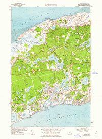
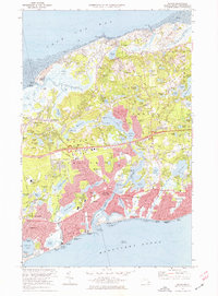
 1949 Dennis1958 Print · USGSMid-century Cape Cod comes to life in this survey of the villages between the bay and the sound. Genealogists and local historians can locate the Bass River Sta, Yarmouth Cem, and early coastal settlements like New Boston.2 unique versions available
 - 1957 Map of Providence
 1957 Providence1957 Print · USGSCoastal New England at the height of the mid-century era shows a landscape shaped by maritime industry and Cold War defense. Genealogists and historians can trace the reach of the New York, New Haven & Hartford RR and locate legacy sites like Fort Adams and Quonset Point Naval Air Station.
 - 1958 Map of Providence
 1958 Providence1958 Print · USGSThe Rhode Island and Massachusetts coastlines are shown in detail during the late 1950s, from the urban cores to the tips of the islands. Researchers can trace the mid-century footprint of Quonset Point Naval Air Station, the defense works at Fort Adams, and the rail network of the New York, New Haven and Hartford RR.
 - 1961 Map of Dennis, 1963 Print
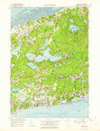
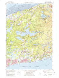
 1961 Dennis1963 Print · USGSCape Cod's mid-century expansion is visible in this survey of the shoreline between Cape Cod Bay and Nantucket Sound. Trace family history and land use through numerous burial sites like Hall Cem and distinctive landmarks such as Hokum Rock and Scargo Lake.2 unique versions available
 - 1961 Map of Harwich, 1964 Print
 1961 Harwich1964 Print · USGSThe Lower Cape's coastal villages and interior cranberry bogs are meticulously charted during the early sixties. Genealogists can trace family names at Evergreen Cem and Brewster Cem, while rail enthusiasts can follow the New York New Haven and Hartford line.2 unique versions available
 - 1963 Map of Providence
 1963 Providence1963 Print · USGSSouthern New England's coastal and industrial heartland is captured here in the early sixties, from the Rhode Island mainland to the far reaches of the Cape. Researchers can trace mid-century growth in Providence or locate landmarks on Marthas Vineyard and Nantucket Island.
 - 1974 Map of Dennis, 1976 Print
 1974 Dennis1976 Print · USGSThe Mid-Cape region's mid-century landscape is preserved here, showing the evolving waterfronts of Dennis and Yarmouth in the early seventies. Genealogists and historians can locate numerous family burial sites like Paddock Cem or trace landmarks such as Hokum Rock and the Cape Cod Coliseum.2 unique versions available
 - 1974 Map of Harwich, 1976 Print
 1974 Harwich1976 Print · USGSCape Cod's mid-century character is preserved here, showing the balance between quiet bay-side villages and bustling sound-side harbors. Genealogists and historians can trace the foundations of local communities through landmarks like Evergreen Cem, Wychmere Harbor, and the La Salette Seminary.3 unique versions available
 - 1977 Map of Dennis, 1981 Print
 1977 Dennis1981 Print · USGSMid-Cape development and coastal geography are captured in this late-seventies aerial survey of the peninsula. Researchers can trace neighborhood growth and the natural courses of the Bass River and Swan Pond River near Dennis Port.
 - 1977 Map of Harwich, 1981 Print
 1977 Harwich1981 Print · USGSMid-century Cape Cod is captured in this photographic survey stretching from Brewster to Harwich Port. Trace coastal development and inland landmarks like Long Pond and the winding Herring River.
 - 1986 Map of New Bedford
 1986 New Bedford1986 Print · USGSSoutheastern Massachusetts and the Cape are shown here during the mid-eighties, a period of notable coastal growth and modernization. Researchers can trace the development of maritime hubs like Woods Hole and New Bedford or locate landmarks within Myles Standish State Forest.
Showing maps 1-25
Top cities near Dennis
- Yarmouth historical maps
- Sandwich historical maps
- Hyannis historical maps
- Mashpee historical maps
- Harwich historical maps
- Brewster historical maps
See more
Top neighborhoods of Dennis
- Dennisport historical maps
- West Dennis historical maps
- South Dennis historical maps
- East Dennis historical maps
- New Boston historical maps
- North Dennis historical maps
Frequently asked questions
- What are the different types of historical maps available for Dennis?
- What is the oldest map of Dennis?
- Where can I purchase historical maps of Dennis for my home or office?
- Where can I download high-res historical maps of Dennis?
- Are there historical topographic maps available for Dennis?
- Is there historical aerial imagery available for Dennis?
- Where are historical maps of Dennis sourced from?