1960s Maps of Harwich, Massachusetts
Explore 5 historic maps of Harwich from the 1960s. These maps offer a rare glimpse into what life looked like during the 1960s — showing old roads, neighborhoods, homes, and landmarks that have changed or disappeared over time.
Whether you're researching your family's past, planning a metal detecting trip, or studying how Harwich's landscape evolved across the 1960s, these high-resolution maps are a powerful tool for exploring the history of this region.
- Focus on a specific era: All maps on this page are from the 1960s, giving you a focused view of this time period.
- See what’s changed: Compare century-old streets, trails, and buildings to today's modern landscape using overlays and satellite layers.
- Research with precision: Use these maps for genealogy, historical research, land use analysis, or educational projects.
- View, download, or print: Maps are fully viewable online in high resolution, and can be downloaded or printed for your own records.
Start exploring Harwich's history through authentic maps from the 1960s. This is your window into the past.
Harwich, MA maps
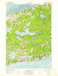
(5)- 1961 Map of Dennis, 1963 Print
 1961 Dennis1963 Print · USGSCape Cod's mid-century expansion is visible in this survey of the shoreline between Cape Cod Bay and Nantucket Sound. Trace family history and land use through numerous burial sites like Hall Cem and distinctive landmarks such as Hokum Rock and Scargo Lake.2 unique versions available
 - 1961 Map of Chatham, 1964 Print
 1961 Chatham1964 Print · USGSCoastal Barnstable County comes to life in this mid-century survey of the southeastern tip of the Cape. Genealogists and local historians can locate Union Cem, the historic Chatham Lighthouse, and family landmarks like Uncle Seths Pond or Nickersons Neck.2 unique versions available
 - 1961 Map of Harwich, 1964 Print
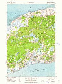
 1961 Harwich1964 Print · USGSThe Lower Cape's coastal villages and interior cranberry bogs are meticulously charted during the early sixties. Genealogists can trace family names at Evergreen Cem and Brewster Cem, while rail enthusiasts can follow the New York New Haven and Hartford line.2 unique versions available
 - 1963 Map of Providence
 1963 Providence1963 Print · USGSSouthern New England's coastal and industrial heartland is captured here in the early sixties, from the Rhode Island mainland to the far reaches of the Cape. Researchers can trace mid-century growth in Providence or locate landmarks on Marthas Vineyard and Nantucket Island.
 - 1964 Map of Monomoy Point, 1965 Print
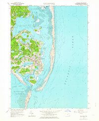
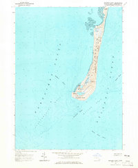 1964 Monomoy Point1965 Print · USGSThe shifting sands of the Cape Cod coast are preserved here during the mid-sixties, detailing a landscape shaped by wind and tide. Maritime researchers can trace the hazardous shoals of Nantucket Sound, including Handkerchief Shoal and the site of the Lighthouse (Abandoned).2 unique versions available
End of results
Showing maps 1-5 of 5
Top cities near Harwich
- Yarmouth historical maps
- Hyannis historical maps
- Dennis historical maps
- Brewster historical maps
- Chatham historical maps
- Orleans historical maps
See more
Top neighborhoods of Harwich
- East Harwich historical maps
- Harwich Port historical maps
- North Harwich historical maps
- Pleasant Lake historical maps
- West Harwich historical maps
- South Harwich historical maps
Frequently asked questions
- What are the different types of historical maps available for Harwich?
- What is the oldest map of Harwich?
- Where can I purchase historical maps of Harwich for my home or office?
- Where can I download high-res historical maps of Harwich?
- Are there historical topographic maps available for Harwich?
- Is there historical aerial imagery available for Harwich?
- Where are historical maps of Harwich sourced from?