1970s Maps of North Truro, Truro
Explore 2 historic maps of North Truro from the 1970s. These maps offer a rare glimpse into what life looked like during the 1970s — showing old roads, neighborhoods, homes, and landmarks that have changed or disappeared over time.
Whether you're researching your family's past, planning a metal detecting trip, or studying how North Truro's landscape evolved across the 1970s, these high-resolution maps are a powerful tool for exploring the history of this region.
- Focus on a specific era: All maps on this page are from the 1970s, giving you a focused view of this time period.
- See what’s changed: Compare century-old streets, trails, and buildings to today's modern landscape using overlays and satellite layers.
- Research with precision: Use these maps for genealogy, historical research, land use analysis, or educational projects.
- View, download, or print: Maps are fully viewable online in high resolution, and can be downloaded or printed for your own records.
Start exploring North Truro's history through authentic maps from the 1970s. This is your window into the past.
North Truro, Truro maps
(2)- 1972 Map of North Truro, 1974 Print
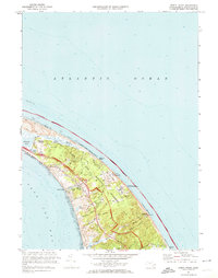 1972 North Truro1974 Print · USGSThe Outer Cape was transitioning into a protected national parkland in the early 1970s, balancing local village life with coastal defense. You can trace family history at Old North Cem or locate cold war history at the North Truro Air Force Station.3 unique versions available
 - 1977 Map of North Truro, 1981 Print
 1977 North Truro1981 Print · USGSThe Outer Cape in the late seventies is revealed through aerial imagery, showing the narrow land between the sea and the bay. Trace the coastal developments of North Truro and the shifting sands along Cape Cod Bay and the Atlantic Ocean.
End of results
Showing maps 1-2 of 2
Top cities near North Truro
- Dennis historical maps
- Brewster historical maps
- Orleans historical maps
- Eastham historical maps
- Provincetown historical maps
- Wellfleet historical maps
See more
Frequently asked questions
- What are the different types of historical maps available for North Truro?
- What is the oldest map of North Truro?
- Where can I purchase historical maps of North Truro for my home or office?
- Where can I download high-res historical maps of North Truro?
- Are there historical topographic maps available for North Truro?
- Is there historical aerial imagery available for North Truro?
- Where are historical maps of North Truro sourced from?