Old Maps of Wellfleet, Massachusetts for Genealogy
Trace your family roots with 38 historic maps of Wellfleet. These high-res maps reveal old neighborhoods, homesites, landmarks, and streets — helping you uncover where your ancestors lived and how the area evolved over time.
- Explore historic neighborhoods: Identify where your relatives may have lived in the 1800s or 1900s.
- Compare maps over time: Trace the changes in streets, buildings, and landmarks for multi-generational research.
- Perfect for genealogy & ancestry research: Used by family historians and researchers to map out lineage and migration.
These maps are an incredible resource for exploring your personal connection to Wellfleet's past.
Wellfleet, MA maps
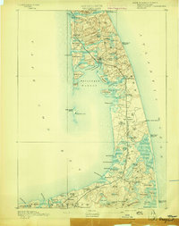
(38)- 1887 Map of Wellfleet
 1887 Wellfleet1887 Print · USGSThe lower Cape comes into focus during the late nineteenth and early twentieth centuries as the railroad reshapes coastal commerce. Genealogists and historians can trace family locations near the Methodist Camp Ground, Mayo's Beach Light, and the Marconi Towers.
 - 1889 Map of Wellfleet
 1889 Wellfleet1889 Print · USGSThe Lower Cape is shown here in the late nineteenth century as a vital maritime and railroad corridor. Genealogists and historians can trace the early rail stops and shoreline landmarks like the Methodist Camp Ground and the Billingsgate Light.
 - 1893 Map of Wellfleet
 1893 Wellfleet1893 Print · USGSCape Cod's outer reaches are shown in the late 1800s, when the Old Colony Railroad served isolated fishing villages and lifesaving stations. Trace historic sites like the Methodist Camp Ground, Billingsgate Light, and early schools at Schoolhouse Pond.8 unique versions available
 - 1942 Map of Cape Cod Bay
 1942 Cape Cod Bay1942 Print · USGSThe mid-Cape and Outer Cape regions are shown here during the early war years, documenting a landscape of coastal villages and maritime trade. Researchers can trace family roots through old settlements like South Truro, find the grounds of Camp Edwards, or locate historic aids like Sandy Neck Light.
 - 1942 Map of Nauset, 1943 Print
 1942 Nauset1943 Print · USGSLower Cape Cod and its maritime frontier are captured here during the early Forties, showing the vital coastal infrastructure of the era. Genealogists and historians can trace family locations and landmarks from South Wellfleet to Chatham, including Nauset Beach Light and several Life Saving Stations.
 - 1944 Map of Wellfleet
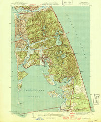 1944 Wellfleet1944 Print · USGSThe outer Cape in the early 1940s is captured here in fine detail, from the rail stop at Truro Sta to the shifting sands of Wellfleet Harbor. Researchers can trace old family lineages through Pleasant Hill Cem or locate vanished sites like Billingsgate Island.5 unique versions available
 - 1947 Map of Providence, 1948 Print
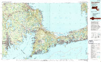
 1947 Providence1948 Print · USGSSouthern New England is captured in the mid-1940s, showing a landscape defined by busy industrial ports and expanding military installations. Researchers can trace the rail lines of the N.Y. N.H. & H. RR or locate coastal defenses like Fort Adams and Quonset Point.5 unique versions available
 - 1948 Map of Providence, 1951 Print
 1948 Providence1951 Print · USGSSouthern New England’s coastal reaches are captured here in the late 1940s, from the industrial heart of Providence to the tip of Provincetown. Genealogists and historians can trace rail lines like the Central Vermont Railway and locate active military sites such as Otis Air Force Base and Fort Rodman.
 - 1957 Map of Providence
 1957 Providence1957 Print · USGSCoastal New England at the height of the mid-century era shows a landscape shaped by maritime industry and Cold War defense. Genealogists and historians can trace the reach of the New York, New Haven & Hartford RR and locate legacy sites like Fort Adams and Quonset Point Naval Air Station.
 - 1958 Map of Providence
 1958 Providence1958 Print · USGSThe Rhode Island and Massachusetts coastlines are shown in detail during the late 1950s, from the urban cores to the tips of the islands. Researchers can trace the mid-century footprint of Quonset Point Naval Air Station, the defense works at Fort Adams, and the rail network of the New York, New Haven and Hartford RR.
 - 1958 Map of Wellfleet, 1960 Print
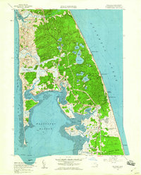 1958 Wellfleet1960 Print · USGSCape Cod's outer arm reveals its mid-century character during the 1950s, showing the early footprint of the Mid-Cape Highway and the Camp Wellfleet military site. Trace family roots at French Cem or locate vintage landmarks like the Drive-in Theater and Camp Mar-Vel.3 unique versions available
 - 1963 Map of Providence
 1963 Providence1963 Print · USGSSouthern New England's coastal and industrial heartland is captured here in the early sixties, from the Rhode Island mainland to the far reaches of the Cape. Researchers can trace mid-century growth in Providence or locate landmarks on Marthas Vineyard and Nantucket Island.
 - 1972 Map of Wellfleet, 1974 Print
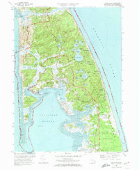 1972 Wellfleet1974 Print · USGSThe Outer Cape's mid-century character is preserved in this 1970s survey of the Wellfleet area. Researchers can trace family-named hollows and historic sites from the Marconi Station Site to the South Wellfleet Cemetery and the Penn Central rail line.3 unique versions available
 - 1977 Map of Wellfleet, 1981 Print
 1977 Wellfleet1981 Print · USGSThe Outer Cape in the late seventies is revealed through detailed aerial imagery of its shifting sands and tidal marshes. Researchers can trace the developed centers of Wellfleet and South Wellfleet set against the Atlantic Ocean.
 - 1986 Map of New Bedford
 1986 New Bedford1986 Print · USGSSoutheastern Massachusetts and the Cape are shown here during the mid-eighties, a period of notable coastal growth and modernization. Researchers can trace the development of maritime hubs like Woods Hole and New Bedford or locate landmarks within Myles Standish State Forest.
 - 1986 Map of Chatham
 1986 Chatham1986 Print · USGSThe outer Cape Cod coastline is frozen in the mid-1980s, showing the delicate barrier beaches and maritime infrastructure before more recent coastal erosion. Researchers can trace landforms and local landmarks like Nauset Beach Lighthouse, the settlements of Chatham, and the protected waters of Pleasant Bay.
 - 1993 Map of Chatham, 1994 Print
 1993 Chatham1994 Print · USGSBarnstable County's outer coast appears here in the early nineties, showcasing the protected lands of the Cape Cod National Seashore. Researchers can trace the shoreline from Nauset Beach Lighthouse down to the Monomoy National Wildlife Refuge.
 - 1994 Map of New Bedford
 1994 New Bedford1994 Print · USGSSoutheastern Massachusetts and the Cape are shown in high detail during the mid-nineties, capturing the region's unique maritime geography and coastal infrastructure. Trace the transition from the industrial New Bedford Harbor to protected lands like Cape Cod National Seashore and Otis Air Force Base.
 - 2012 Map of Wellfleet OE E, 2012 Print
 2012 Wellfleet OE E2012 Print · USGSCovers Wellfleet, including Eastham, Truro, and other nearby areas
 - 2012 Map of Wellfleet, 2012 Print
 2012 Wellfleet2012 Print · USGSCovers Wellfleet, including Eastham, Truro, and other nearby areas
 - 2012 Map of Orleans OE W, 2012 Print
 2012 Orleans OE W2012 Print · USGSCovers Wellfleet, including Dennis, Brewster, and other nearby areas
 - 2012 Map of Dennis OE N, 2012 Print
 2012 Dennis OE N2012 Print · USGSCovers Wellfleet, including Yarmouth, Dennis, and other nearby areas
 - 2015 Map of Wellfleet OE E, 2015 Print
 2015 Wellfleet OE E2015 Print · USGSCovers Wellfleet, including Eastham, Truro, and other nearby areas
 - 2015 Map of Dennis OE N, 2015 Print
 2015 Dennis OE N2015 Print · USGSCovers Wellfleet, including Yarmouth, Dennis, and other nearby areas
 - 2015 Map of Wellfleet, 2015 Print
 2015 Wellfleet2015 Print · USGSCovers Wellfleet, including Eastham, Truro, and other nearby areas
Showing maps 1-25 of 38
Top cities near Wellfleet
- Yarmouth historical maps
- Dennis historical maps
- Harwich historical maps
- Brewster historical maps
- Chatham historical maps
- Orleans historical maps
See more
Top neighborhoods of Wellfleet
- South Wellfleet historical maps
- Mayo Beach historical maps
- Newcomb Hollow historical maps
- Cahoon Hollow historical maps
- Fresh Brook historical maps
- Wellfleet by the Sea historical maps
Frequently asked questions
- What are the different types of historical maps available for Wellfleet?
- What is the oldest map of Wellfleet?
- Where can I purchase historical maps of Wellfleet for my home or office?
- Where can I download high-res historical maps of Wellfleet?
- Are there historical topographic maps available for Wellfleet?
- Is there historical aerial imagery available for Wellfleet?
- Where are historical maps of Wellfleet sourced from?