Old Maps of Mansfield, Massachusetts
Explore 74 old maps of Mansfield, spanning from 1885 to today. These high-resolution historic maps reveal how streets, neighborhoods, landmarks, and natural features evolved over time — perfect for genealogy, metal detecting, research, and local history exploration.
What you can do with these maps:
- See how Mansfield changed over time: Compare historical maps to modern-day views to trace roads, homesites, rail lines & more.
- View detailed metadata: Each map includes creators, publishers, year, scale, and archive source.
- Overlay maps with satellite & LiDAR: Visualize the past alongside modern tools to explore terrain & human change.
- Trusted historical sources: Maps sourced from the USGS, Library of Congress, and other archives.
- Access maps your way: View online, download high-res files, or order prints for personal or research use.
Start exploring old maps of Mansfield to uncover forgotten places, hidden landmarks, and the deep history beneath your feet.
Mansfield, MA maps
(74)- 1885 Map of Taunton
 1885 Taunton1885 Print · USGSTaunton and the surrounding Bristol County townships are shown here during a period of significant industrial and rail expansion. Researchers can trace historic family landmarks and local institutions like the State Hospital for the Insane, Dighton Rock, and the Swansea Factory.
 - 1886 Map of Dedham
 1886 Dedham1886 Print · USGSNorfolk County and its neighbors are captured here in the late nineteenth century as the rail networks expanded across eastern Massachusetts. Local historians can trace the routes of the Old Colony Railroad and find early village sites like Furnace Village and Sharon Heights.
 - 1887 Map of Franklin
 1887 Franklin1887 Print · USGSNorfolk County at the peak of the industrial rail era shows a complex landscape of mill villages and expanding transit lines. Trace the development of City Mills, follow the Old Colony R. R. Wrentham Branch, or locate old landmarks like Burnt Swamp Corner.
 - 1887 Map of Providence
 1887 Providence1887 Print · USGSProvidence and its surrounding mill towns are captured here at the height of the industrial era. Trace the rail-and-river infrastructure of the Blackstone River through Lorraine Mills, Saylesville, and the Cranston Print Works.
 - 1888 Map of Taunton
 1888 Taunton1888 Print · USGSIn the late nineteenth century, this region of Bristol County was a bustling industrial and rail center. Researchers can trace the extensive Old Colony Railroad network through specialized stops like Britanniaville Station and Cranes Station.
 - 1889 Map of Providence
 1889 Providence1889 Print · USGSProvidence and its industrial corridors thrive at the close of the nineteenth century as a massive rail-and-water network takes shape. Genealogists and historians can trace the foundations of local industry at the Sayles Bleachery or locate long-standing institutions like Friends School and Dexter Asylum.
 - 1889 Map of Franklin
 1889 Franklin1889 Print · USGSThe industrial and rail hubs of Norfolk County are detailed in the late 1880s, documenting a time of rapid growth for mill towns and village centers. Researchers can trace historic station stops and hamlets like City Mills, Unionville, and Whitney Sta.
 - 1893 Map of Taunton
 1893 Taunton1893 Print · USGSTaunton flourished as a rail and manufacturing powerhouse during the late nineteenth century, situated at the nexus of the Old Colony Railroad system. Genealogists and historians can trace the early industrial sites like the Copper Works and Swansea Factory or find local landmarks such as Dighton Rock and the town Almshouse.7 unique versions available
 - 1893 Map of Franklin
 1893 Franklin1893 Print · USGSEastern Massachusetts at the close of the nineteenth century was a landscape of busy rail junctions and riverside mill towns. Researchers can trace the era's industrial footprint through sites like City Mills, Medfield Junc., and the isolated Burnt Swamp Corner.8 unique versions available
 - 1894 Map of Dedham
 1894 Dedham1894 Print · USGSGreater Boston's southern suburbs emerge during the late nineteenth century as a dense network of railroad lines and water-powered industrial centers. Genealogists and historians can trace old neighborhoods from Readville and Endicott to the heights of Great Blue Hill.10 unique versions available
 - 1894 Map of Providence
 1894 Providence1894 Print · USGSThe industrial corridor from Providence to Pawtucket thrives in the 1890s as a hub of rail and river commerce. Genealogists can trace early neighborhood lines and locate vanished institutions like the Dexter Asylum, Sayles Bleachery, and the Butler Hospital.10 unique versions available
 - 1918 Map of Taunton, 1921 Print
 1918 Taunton1921 Print · USGSSoutheastern Massachusetts at the close of the Great War is a dense network of industrial rail lines and riverside villages. You can trace the path of the Old Colony Railroad Main Line or locate local landmarks like the Copper Works and Annawon Rock.
 - 1919 Map of Dedham
 1919 Dedham1919 Print · USGSNorfolk County at the close of the Great War reveals a landscape defined by the Blue Hills Reservation and a dense network of industrial rail lines. Genealogists and historians can trace old neighborhood boundaries in Readville and Islington or locate lost trackside stops along the Old Colony RR.
 - 1919 Map of Franklin
 1919 Franklin1919 Print · USGSEastern Massachusetts at the end of the Great War was a landscape defined by its river-powered mill towns and expanding rail corridors. Genealogists and local historians can trace family roots through industrial hamlets like City Mills, Unionville, and Sheldonville.2 unique versions available
 - 1921 Map of Providence
 1921 Providence1921 Print · USGSProvidence and its industrial satellites are captured here at the height of the rail-and-mill era. Genealogists and historians can trace old neighborhoods and worksites like Sayles Bleachery, the Dexter Asylum, and Lonsdale Station.
 - 1921 Map of Franklin, 1942 Print
 1921 Franklin1942 Print · USGSThe Charles River valley was a network of bustling rail junctions and mill villages in the years following the Great War. You can trace the development of towns like Franklin and Medway or locate smaller centers such as City Mills and Unionville.
 - 1936 Map of Mansfield
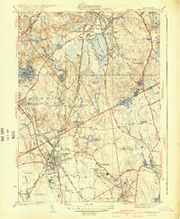
 1936 Mansfield1936 Print · USGSMansfield and its neighboring villages are shown during the mid-1930s, when the region functioned as a vital railway hub for the New York New Haven and Hartford RR. Researchers can locate family sites and old landmarks like Furnace Village, St Marys Cem, and the Hartwell Sch.
 - 1940 Map of Wrentham
 1940 Wrentham1940 Print · USGSNorfolk County in the late 1930s shows a landscape of busy mill villages and expanding state institutions. Genealogists can trace family roots through the Bacon Cem, Quaker Cem, and local schools like Vogel Sch and Everett Sch.2 unique versions available
 - 1941 Map of Mansfield
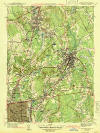
 1941 Mansfield1941 Print · USGSThe Norfolk and Bristol county borderlands are shown here just before the mid-century suburban boom, centered on the New York New Haven and Hartford rail corridor. Genealogists and historians can locate old rural corners like Ginty Corner and school sites such as the Poquanticut Sch.3 unique versions available
 - 1943 Map of Providence
 1943 Providence1943 Print · USGSNarragansett Bay and the industrial Blackstone Valley appear here in the midst of the Second World War. Genealogists and researchers can trace local landmarks like Lonsdale Station, the St Marys Reservoir, and the Rhode Island State Airport.
 - 1943 Map of Boston
 1943 Boston1943 Print · USGSGreater Boston and its southern suburbs appear here during the mobilization of the early 1940s. Genealogists and historians can trace the early footprints of Commonwealth Airport, military sites like Fort Winthrop, and local institutions such as Pondville State Hospital.
 - 1943 Map of Attleboro
 1943 Attleboro1943 Print · USGSAttleboro and its surrounding mill villages are captured here during the Second World War era. Researchers can trace ancestral roots through sites like the Old Town Hall, Newell Cem, and the specialized Attleboro Springs Sanitarium.3 unique versions available
 - 1944 Map of Norton
 1944 Norton1944 Print · USGSMid-century Bristol County reveals a landscape of emerging industry and military mobilization just before post-war suburbanization. Trace the rail-and-river economy through landmarks like the Copper Works, the campus of Wheaton College, and the sprawling Camp Miles Standish.2 unique versions available
 - 1945 Map of Wrentham, 1958 Print
 1945 Wrentham1958 Print · USGSIn the mid-1940s, this area of Norfolk County maintained its rural character through small villages and institutional landmarks. Researchers can trace ancestral sites like St Marys Cem and Wampum Corner, or locate early infrastructure such as Wilkins Airport.
 - 1946 Map of Wrentham
 1946 Wrentham1946 Print · USGSThe borderlands of Norfolk and Bristol counties are shown here just after the war, at a time when local institutions and textile-era rail lines defined the landscape. Genealogists and historians can trace family plots at Norfolk Cem or Quaker Cem, and locate early landmarks like Wilkins Airport and Wampum Corner.2 unique versions available
Showing maps 1-25 of 74
Top cities near Mansfield
- Boston historical maps
- Providence historical maps
- Brockton historical maps
- Quincy historical maps
- Cranston historical maps
- Pawtucket historical maps
See more
Top neighborhoods of Mansfield
- East Mansfield historical maps
- Ginty Corner historical maps
- Purdy Corner historical maps
- West Mansfield historical maps
- Robinsonville historical maps
- Whiteville historical maps
Frequently asked questions
- What are the different types of historical maps available for Mansfield?
- What is the oldest map of Mansfield?
- Where can I purchase historical maps of Mansfield for my home or office?
- Where can I download high-res historical maps of Mansfield?
- Are there historical topographic maps available for Mansfield?
- Is there historical aerial imagery available for Mansfield?
- Where are historical maps of Mansfield sourced from?