Old Maps of New Bedford, Massachusetts for Metal Detecting
Plan your next treasure hunt with 33 historic maps of New Bedford. Find old homesites, ghost towns, trails, and gathering spots that may be lost to time — perfect for identifying promising metal detecting locations.
- Locate forgotten sites: Uncover places like long-lost settlements, abandoned rail lines, or gathering spots.
- Plan better hunts: Use map overlays combined with LiDAR or satellite views to narrow in on historically rich areas.
- Made for detectorists: Thousands of hobbyists use these maps to discover relics, coins, and hidden history.
Use these historic maps to boost your research and find new opportunities beneath the surface of New Bedford.
New Bedford, MA maps
(33)- 1885 Map of New Bedford
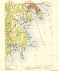
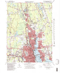
 1885 New Bedford1885 Print · USGSThe Buzzards Bay coastline and its industrial hubs are captured here as the maritime economy met the rising age of rail. Genealogy and local history researchers can trace the streets of New Bedford, the tracks of the Old Colony Railroad, and coastal landmarks like Clark Point Light.
 - 1888 Map of New Bedford
 1888 New Bedford1888 Print · USGSThe bustling whale oil and textile hub of New Bedford is shown here at its maritime peak in the late nineteenth century. Genealogists can trace early neighborhood grids and find outlying rural stops like Braleys Station, Turners Mills, and Nasketucket.
 - 1893 Map of New Bedford
 1893 New Bedford1893 Print · USGSThe South Coast of Massachusetts is captured here in the late nineteenth century as a hub of maritime trade and rail transit. Researchers can trace the waterfront development of New Bedford, find old coastal lights like Neds Point Light, and locate family settlements at Potomska and Apponagansett.9 unique versions available
 - 1918 Map of New Bedford, 1921 Print
 1918 New Bedford1921 Print · USGSThe Buzzards Bay coastline thrived with rail and maritime commerce during the early twentieth century. Researchers can trace historic shorelines and infrastructure at New Bedford, Fairhaven, and Clark Point Light.
 - 1936 Map of New Bedford North
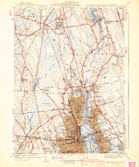
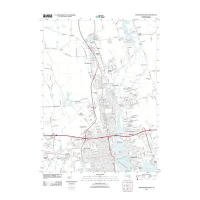
 1936 New Bedford North1936 Print · USGSGreater New Bedford in the mid-thirties shows a fascinating contrast between its bustling riverfront and the expansive cedar swamps to the north. Genealogists and historians can trace family plots in Riverside Cem, locate the Bluestone Quarry, or find old schoolhouses like the Faunces Cor Sch.
 - 1936 Map of South Dartmouth
 1936 South Dartmouth1936 Print · USGSCoastal Bristol County is captured here in the mid-1930s, showing a landscape defined by maritime navigation and harbor defenses. Researchers can trace early aviation at the Round Hill Landing Field and locate family landmarks like Crapo Sch or the Rural Cemetery.
 - 1941 Map of New Bedford South
 1941 New Bedford South1941 Print · USGSCoastal Massachusetts at the start of the 1940s reveals a landscape of harbor defenses, seaside villages, and rural schools. Researchers can trace historic family-named landmarks and institutions like Fort Phoenix, St Johns Ch, and the Padanaram Breakwater.3 unique versions available
 - 1941 Map of New Bedford North
 1941 New Bedford North1941 Print · USGSIn the early 1940s, the New Bedford waterfront was a complex network of rail and industry. Trace the historic neighborhoods of Fairhaven and Acushnet, locating family landmarks like St Marys Cem or the Evergreen Racetrack.3 unique versions available
 - 1942 Map of New Bedford
 1942 New Bedford1942 Print · USGSSoutheastern Massachusetts at the start of the 1940s shows a region defined by maritime defense and industrial rail corridors. Genealogists and historians can trace the massive Camp Edwards boundary, old rail stops like Rock Station, and vanished local industry at Paper Mill Village.2 unique versions available
 - 1947 Map of Providence, 1948 Print
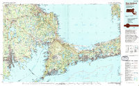
 1947 Providence1948 Print · USGSSouthern New England is captured in the mid-1940s, showing a landscape defined by busy industrial ports and expanding military installations. Researchers can trace the rail lines of the N.Y. N.H. & H. RR or locate coastal defenses like Fort Adams and Quonset Point.5 unique versions available
 - 1948 Map of Providence, 1951 Print
 1948 Providence1951 Print · USGSSouthern New England’s coastal reaches are captured here in the late 1940s, from the industrial heart of Providence to the tip of Provincetown. Genealogists and historians can trace rail lines like the Central Vermont Railway and locate active military sites such as Otis Air Force Base and Fort Rodman.
 - 1948 Map of New Bedford North, 1958 Print
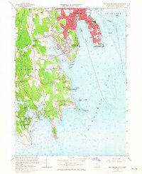
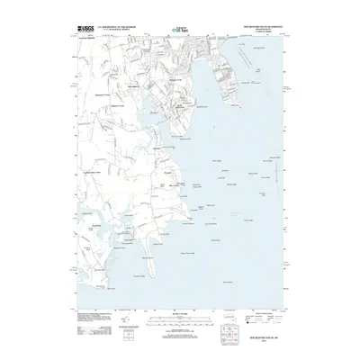
 1948 New Bedford North1958 Print · USGSCoastal Massachusetts at the end of the 1940s reveals a bustling maritime economy anchored by the New Bedford Harbor. Researchers can trace old neighborhood lines, find family plots at Oak Grove Cem, or locate the historic Whaling Museum and Bluestone Quarry.
 - 1948 Map of New Bedford South, 1958 Print
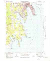
 1948 New Bedford South1958 Print · USGSThe Buzzards Bay shoreline comes alive in the late 1940s, showing the transition from coastal defense to a growing residential and maritime community. Researchers can trace local landmarks like Fort Rodman, the Butler Flats Lighthouse, and vanished schoolhouses such as the Crapo School.
 - 1957 Map of Providence
 1957 Providence1957 Print · USGSCoastal New England at the height of the mid-century era shows a landscape shaped by maritime industry and Cold War defense. Genealogists and historians can trace the reach of the New York, New Haven & Hartford RR and locate legacy sites like Fort Adams and Quonset Point Naval Air Station.
 - 1958 Map of Providence
 1958 Providence1958 Print · USGSThe Rhode Island and Massachusetts coastlines are shown in detail during the late 1950s, from the urban cores to the tips of the islands. Researchers can trace the mid-century footprint of Quonset Point Naval Air Station, the defense works at Fort Adams, and the rail network of the New York, New Haven and Hartford RR.
 - 1963 Map of Providence
 1963 Providence1963 Print · USGSSouthern New England's coastal and industrial heartland is captured here in the early sixties, from the Rhode Island mainland to the far reaches of the Cape. Researchers can trace mid-century growth in Providence or locate landmarks on Marthas Vineyard and Nantucket Island.
 - 1963 Map of New Bedford South, 1965 Print
 1963 New Bedford South1965 Print · USGSThe Buzzards Bay coastline in the 1960s reveals a mix of dense South Coast urbanism and rural salt marshes. Researchers can trace historic family crossroads like Wilburite Corner, coastal estates in Nonquitt, and the sprawling Fort Rodman Military Reservation.2 unique versions available
 - 1964 Map of New Bedford North, 1966 Print
 1964 New Bedford North1966 Print · USGSCoastal Massachusetts at the height of the mid-century shows the industrial heart of New Bedford and the developing residential reaches of Acushnet. Genealogists and historians can trace numerous schools and cemeteries, from Long Plain Cem to the Sacred Heart Academy.
 - 1977 Map of New Bedford South, 1979 Print
 1977 New Bedford South1979 Print · USGSThe coastal stretches of South Dartmouth and New Bedford are captured here in the late seventies, showing a landscape of maritime history and suburban growth. Genealogists can trace family plots and local landmarks like Rural Cemetery, Potomska Cem, and the De Mello Sch.3 unique versions available
 - 1977 Map of New Bedford North, 1981 Print
 1977 New Bedford North1981 Print · USGSCoastal Massachusetts at the end of the 1970s reveals a landscape of industrial harbor towns and expanding northern woods. Trace the dense street grids of New Bedford and Fairhaven or locate early development near Acushnet and Braleys.
 - 1979 Map of New Bedford North
 1979 New Bedford North1979 Print · USGSThe industrial waterfront of New Bedford and Fairhaven is shown here in the late seventies alongside the vast protected wetlands of the interior. Trace family roots and local history through dozens of named landmarks like Sacred Heart Cem, Acushnet Sch, and the New Bedford Municipal Airport.2 unique versions available
 - 1986 Map of New Bedford
 1986 New Bedford1986 Print · USGSSoutheastern Massachusetts and the Cape are shown here during the mid-eighties, a period of notable coastal growth and modernization. Researchers can trace the development of maritime hubs like Woods Hole and New Bedford or locate landmarks within Myles Standish State Forest.
 - 1994 Map of New Bedford
 1994 New Bedford1994 Print · USGSSoutheastern Massachusetts and the Cape are shown in high detail during the mid-nineties, capturing the region's unique maritime geography and coastal infrastructure. Trace the transition from the industrial New Bedford Harbor to protected lands like Cape Cod National Seashore and Otis Air Force Base.
 - 2012 Map of New Bedford North, 2012 Print
 2012 New Bedford North2012 Print · USGSCovers New Bedford, including Dartmouth, Fairhaven, and other nearby areas
 - 2012 Map of New Bedford South, 2012 Print
 2012 New Bedford South2012 Print · USGSCovers New Bedford, including Dartmouth, Fairhaven, and other nearby areas
Showing maps 1-25 of 33
Top cities near New Bedford
- Fall River historical maps
- Plymouth historical maps
- Taunton historical maps
- Dartmouth historical maps
- Falmouth historical maps
- Wareham historical maps
See more
Top neighborhoods of New Bedford
- Clifford historical maps
- Mount Pleasant historical maps
- Plainville historical maps
- Rockdale historical maps
- Westgate Park historical maps
- Westview Park historical maps
See more
Frequently asked questions
- What are the different types of historical maps available for New Bedford?
- What is the oldest map of New Bedford?
- Where can I purchase historical maps of New Bedford for my home or office?
- Where can I download high-res historical maps of New Bedford?
- Are there historical topographic maps available for New Bedford?
- Is there historical aerial imagery available for New Bedford?
- Where are historical maps of New Bedford sourced from?