1970s Maps of Central Village, Westport
Explore 1 historic maps of Central Village from the 1970s. These maps offer a rare glimpse into what life looked like during the 1970s — showing old roads, neighborhoods, homes, and landmarks that have changed or disappeared over time.
Whether you're researching your family's past, planning a metal detecting trip, or studying how Central Village's landscape evolved across the 1970s, these high-resolution maps are a powerful tool for exploring the history of this region.
- Focus on a specific era: All maps on this page are from the 1970s, giving you a focused view of this time period.
- See what’s changed: Compare century-old streets, trails, and buildings to today's modern landscape using overlays and satellite layers.
- Research with precision: Use these maps for genealogy, historical research, land use analysis, or educational projects.
- View, download, or print: Maps are fully viewable online in high resolution, and can be downloaded or printed for your own records.
Start exploring Central Village's history through authentic maps from the 1970s. This is your window into the past.
Central Village, Westport maps
(1)- 1977 Map of Westport, 1979 Print
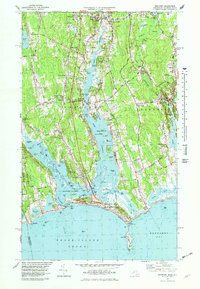 1977 Westport1979 Print · USGSThe coastal stretches of Westport and Dartmouth appear here in the mid-seventies, showing a landscape of salt marshes, barrier beaches, and river estuaries. Genealogists and researchers can trace lineage through old village centers like Westport Point and the Friends Meeting House, or find family-named crossroads such as Gidleys Corner.5 unique versions available
End of results
Showing maps 1-1 of 1
Top cities near Central Village
- New Bedford historical maps
- Fall River historical maps
- Dartmouth historical maps
- Bristol historical maps
- Newport historical maps
- Somerset historical maps
See more
Frequently asked questions
- What are the different types of historical maps available for Central Village?
- What is the oldest map of Central Village?
- Where can I purchase historical maps of Central Village for my home or office?
- Where can I download high-res historical maps of Central Village?
- Are there historical topographic maps available for Central Village?
- Is there historical aerial imagery available for Central Village?
- Where are historical maps of Central Village sourced from?