1970s Maps of Haverhill, Massachusetts
Explore 4 historic maps of Haverhill from the 1970s. These maps offer a rare glimpse into what life looked like during the 1970s — showing old roads, neighborhoods, homes, and landmarks that have changed or disappeared over time.
Whether you're researching your family's past, planning a metal detecting trip, or studying how Haverhill's landscape evolved across the 1970s, these high-resolution maps are a powerful tool for exploring the history of this region.
- Focus on a specific era: All maps on this page are from the 1970s, giving you a focused view of this time period.
- See what’s changed: Compare century-old streets, trails, and buildings to today's modern landscape using overlays and satellite layers.
- Research with precision: Use these maps for genealogy, historical research, land use analysis, or educational projects.
- View, download, or print: Maps are fully viewable online in high resolution, and can be downloaded or printed for your own records.
Start exploring Haverhill's history through authentic maps from the 1970s. This is your window into the past.
Haverhill, MA maps
(4)- 1972 Map of Haverhill, 1973 Print
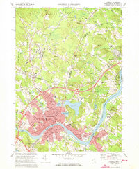 1972 Haverhill1973 Print · USGSHaverhill and the Merrimack River valley are caught in a moment of regional growth during the early seventies. Genealogists and local historians can trace the development of Bradford and Groveland, locate family plots in Linwood Cem, or find the Whittier Birthplace.4 unique versions available
 - 1977 Map of Salem Depot, 1981 Print
 1977 Salem Depot1981 Print · USGSRockingham County in the late seventies is captured here through detailed aerial imagery along the Massachusetts border. Researchers can trace the development of Salem Depot and find the exact shorelines of Canobie Lake and Millville Lake.
 - 1977 Map of Haverhill, 1981 Print
 1977 Haverhill1981 Print · USGSThe Merrimack Valley at the end of the seventies shows a region in transition from its industrial roots to modern suburban expansion. Genealogists and local historians can trace property boundaries and neighborhood growth around Haverhill, Plaistow, and Kenoza Lake.
 - 1977 Map of Newburyport West, 1981 Print
 1977 Newburyport West1981 Print · USGSThe coastal corridor of Essex County is captured in the late seventies, showing the established layouts of Amesbury and Newburyport. Researchers can trace the winding banks of the Merrimack River and locate historic village centers like Byfield and West Newbury.
End of results
Showing maps 1-4 of 4
Top cities near Haverhill
- Lowell historical maps
- Lawrence historical maps
- Peabody historical maps
- Methuen historical maps
- Beverly historical maps
- Billerica historical maps
See more
Top neighborhoods of Haverhill
- Bradford historical maps
- Highlandville historical maps
- Riverside historical maps
- Rocks Village historical maps
- Rosemont historical maps
- West Parish historical maps
See more
Frequently asked questions
- What are the different types of historical maps available for Haverhill?
- What is the oldest map of Haverhill?
- Where can I purchase historical maps of Haverhill for my home or office?
- Where can I download high-res historical maps of Haverhill?
- Are there historical topographic maps available for Haverhill?
- Is there historical aerial imagery available for Haverhill?
- Where are historical maps of Haverhill sourced from?