Old Maps of Essex County, Massachusetts
Explore 259 old maps of Essex County, spanning from 1886 to today. These high-resolution historic maps reveal how streets, neighborhoods, landmarks, and natural features evolved over time — perfect for genealogy, metal detecting, research, and local history exploration.
What you can do with these maps:
- See how Essex County changed over time: Compare historical maps to modern-day views to trace roads, homesites, rail lines & more.
- View detailed metadata: Each map includes creators, publishers, year, scale, and archive source.
- Overlay maps with satellite & LiDAR: Visualize the past alongside modern tools to explore terrain & human change.
- Trusted historical sources: Maps sourced from the USGS, Library of Congress, and other archives.
- Access maps your way: View online, download high-res files, or order prints for personal or research use.
Start exploring old maps of Essex County to uncover forgotten places, hidden landmarks, and the deep history beneath your feet.
Essex County, MA maps
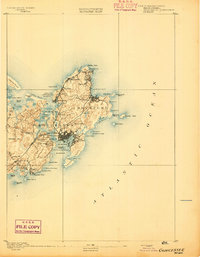
(259)- 1886 Map of Gloucester
 1886 Gloucester1886 Print · USGSCape Ann at the close of the nineteenth century reveals a landscape defined by its deep granite quarries and world-famous fishing fleet. Trace the ancestral footprints of maritime families in Gloucester and Rockport, or locate long-lost stops like West Gloucester Station along the Boston and Maine Railroad.
 - 1886 Map of Lawrence
 1886 Lawrence1886 Print · USGSThe Merrimack Valley at the close of the nineteenth century was a bustling hub of industry and transit. Researchers can trace ancestral roots through vanished hamlets like Frye Village, locate the original Andover Theological Seminary, and follow the old Salem and Lawrence Railroad line.
 - 1886 Map of Lowell
 1886 Lowell1886 Print · USGSThe industrial heart of the Merrimack Valley is captured here in the late nineteenth century, showing the expansion of textile hubs and rail networks. Genealogists and historians can trace family-named hills and early transit stops like Bedford Springs Station, Forge Village, and the Hudson Poor Farm.
 - 1888 Map of Newburyport
 1888 Newburyport1888 Print · USGSThe North Shore and Seacoast regions meet at the turn of the century along the Merrimac River. Trace the early rail lines of the Boston and Maine Railroad or locate coastal landmarks like the U.S. Life Saving Station and Range Light.
 - 1888 Map of Haverhill
 1888 Haverhill1888 Print · USGSThe Merrimack Valley at the end of the nineteenth century reveals a landscape shaped by heavy rail and river industry. Genealogists can trace family footprints through historic hubs like Salem Depot, Ayers Village, and the bustling streets of Haverhill.
 - 1888 Map of Gloucester
 1888 Gloucester1888 Print · USGSCape Ann's maritime landscape at the peak of the Victorian era shows a rugged coast of granite quarries and fishing ports. Trace the early tracks of the Boston and Maine Railroad and locate vanished landmarks like Freshwater Cove Village or the light at Thatchers Island.
 - 1888 Map of Lawrence
 1888 Lawrence1888 Print · USGSThe Merrimack Valley industrial corridor is captured here in the late nineteenth century as a thriving rail and textile hub. Researchers can trace the footprints of the Andover Theological Seminary, locate the State Almshouse, and follow the iron tracks through Ballardvale.
 - 1888 Map of Salem
 1888 Salem1888 Print · USGSThe North Shore in the late nineteenth century is captured here in its era of peak rail development. Genealogists and historians can trace family-named sites like Doles Corner and institutions such as Dummer Academy or the Insane Asylum.
 - 1890 Map of Haverhill
 1890 Haverhill1890 Print · USGSSoutheastern New Hampshire and northern Massachusetts meet here in the 1890s along the industrial corridor of the Merrimac River. Local historians can trace the early rail network through Newton Junction, Salem Depot, and the dense street grids of Haverhill.
 - 1890 Map of Newburyport
 1890 Newburyport1890 Print · USGSThe coastal borderlands of Massachusetts and New Hampshire are shown here during a peak era of maritime and rail activity. Genealogists and local historians can trace family-named sites across Newbury Old Town, Byfield, and the bustling docks at Salisbury Point.
 - 1892 Map of Boston Bay
 1892 Boston Bay1892 Print · USGSThe outer harbor and North Shore coastline are captured in the late Victorian era, before modern development reshaped the beaches and islands. Genealogists and maritime historians can trace the early rail lines to Revere Beach or locate historic defenses like Fort Warren and the iconic Boston Light.4 unique versions available
 - 1893 Map of Lowell
 1893 Lowell1893 Print · USGSThe Merrimack Valley’s industrial and rail landscape comes alive in the late nineteenth century, centering on the growing city of Lowell. Genealogists and historians can trace old property lines across Pelham, locate the Flat Rock Quarry, or follow the routes of the Stony Brook Railroad through Graniteville.9 unique versions available
 - 1893 Map of Salem
 1893 Salem1893 Print · USGSCoastal Massachusetts at the end of the nineteenth century reveals a landscape defined by industrial rail lines and ancient marshlands. Genealogists and historians can trace family-named hills and early institutional sites like Dummer Academy, the Insane Asylum, and the Ipswich Light.11 unique versions available
 - 1893 Map of Boston
 1893 Boston1893 Print · USGSGreater Boston and the Massachusetts coast are captured here in the late nineteenth century as streetcar suburbs and rail lines redefined the region. Trace family roots and local history across old neighborhoods like Washington Village, coastal landmarks like Fort Independence, and the sprawling Middlesex Fells.4 unique versions available
 - 1893 Map of Lawrence
 1893 Lawrence1893 Print · USGSThe Merrimac River valley and its surrounding textile and rail hubs are captured here at their industrial peak during the 1880s. Genealogists can trace family footprints through the State Almshouse, the Andover Theological Seminary, and vanished stops like Burtts Crossing Station.10 unique versions available
 - 1893 Map of Gloucester
 1893 Gloucester1893 Print · USGSCape Ann's rugged maritime communities were firmly established by the 1890s, centered on the bustling port of Gloucester. Researchers can trace the coastal neighborhoods of Lanesville and Annisquam or locate family landmarks like Freshwater Cove Village and the Boston and Maine Railroad line.9 unique versions available
 - 1893 Map of Haverhill
 1893 Haverhill1893 Print · USGSThe Merrimack Valley at the end of the nineteenth century was a bustling network of rail-side villages and river industry. Genealogists can trace family lines through transit hubs like Newton Junction, rural hamlets like Ayer Village, and local landmarks like Spicket Hill.7 unique versions available
 - 1894 Map of Newburyport
 1894 Newburyport1894 Print · USGSCoastal Massachusetts and New Hampshire are captured here in the late nineteenth century, from the bustling riverfront of Newburyport to the marshes of Hampton. Genealogists and historians can trace rail lines, coastal landmarks like the U.S. Life Saving Station, and old neighborhoods in Amesbury or Newbury Old Town.7 unique versions available
 - 1903 Map of Boston
 1903 Boston1903 Print · USGSThe Greater Boston area and its sprawling rail-and-river network are captured here at the turn of the century. Genealogists and historians can trace neighborhood blocks, the grounds of Tufts College, and military landmarks like Ft. Winthrop and Ft. Independence.13 unique versions available
 - 1903 Map of Boston Bay
 1903 Boston Bay1903 Print · USGSThe Massachusetts North and South Shores are seen here at the turn of the century as a hub of rail-connected maritime life. You can trace the path of old rail divisions to historic coastal landings at Point of Pines, Marblehead, and the naval defenses at Ft. Warren.9 unique versions available
 - 1917 Map of Salem
 1917 Salem1917 Print · USGSCoastal Massachusetts at the end of the Great War reveals a landscape of maritime commerce and rail-connected villages. Trace the local economy from Salem Harbor to Ipswich Light, or locate historic sites like Dummer Academy and the Insane Asylum.
 - 1918 Map of Lowell
 1918 Lowell1918 Print · USGSGreater Lowell and the Merrimack Valley are shown at their industrial peak during the First World War. Genealogists can trace family connections to mill-town life in Middlesex Village or locate rural landmarks like Flat Rock Quarry and the Old Middlesex Canal.
 - 1918 Map of Lawrence
 1918 Lawrence1918 Print · USGSGreater Lawrence and the Merrimac Valley are captured here during the late First World War era, showing a landscape defined by industrial rail and historic village centers. Researchers can trace the sprawling Boston and Maine Railroad network to specific sites like the State Almshouse or the Andover Theological Seminary.2 unique versions available
 - 1918 Map of Gloucester, 1921 Print
 1918 Gloucester1921 Print · USGSCape Ann's rugged shoreline and maritime villages are captured here during the first World War. Trace early twentieth-century coastal life through landmarks like Squam Light, the West Gloucester Sta., and family-named points like Wheeler Point.
 - 1919 Map of Salem
 1919 Salem1919 Print · USGSThe North Shore and its rail-connected towns are captured here during the height of the steam era. Genealogists and historians can trace the local landscape through landmarks like Dummer Academy, the Insane Asylum, and the vanished Box Factory.2 unique versions available
Showing maps 1-25 of 259
Top cities of Essex County
- Lynn historical maps
- Lawrence historical maps
- Haverhill historical maps
- Peabody historical maps
- Methuen historical maps
- Salem historical maps
See more
Frequently asked questions
- What are the different types of historical maps available for Essex County?
- What is the oldest map of Essex County?
- Where can I purchase historical maps of Essex County for my home or office?
- Where can I download high-res historical maps of Essex County?
- Are there historical topographic maps available for Essex County?
- Is there historical aerial imagery available for Essex County?
- Where are historical maps of Essex County sourced from?