1940s Maps of Essex County, Massachusetts
Explore 32 historic maps of Essex County from the 1940s. These maps offer a rare glimpse into what life looked like during the 1940s — showing old roads, neighborhoods, homes, and landmarks that have changed or disappeared over time.
Whether you're researching your family's past, planning a metal detecting trip, or studying how Essex County's landscape evolved across the 1940s, these high-resolution maps are a powerful tool for exploring the history of this region.
- Focus on a specific era: All maps on this page are from the 1940s, giving you a focused view of this time period.
- See what’s changed: Compare century-old streets, trails, and buildings to today's modern landscape using overlays and satellite layers.
- Research with precision: Use these maps for genealogy, historical research, land use analysis, or educational projects.
- View, download, or print: Maps are fully viewable online in high resolution, and can be downloaded or printed for your own records.
Start exploring Essex County's history through authentic maps from the 1940s. This is your window into the past.
Essex County, MA maps
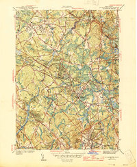
(32)- 1941 Map of Lowell
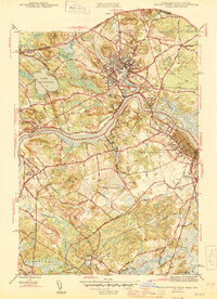
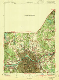 1941 Lowell1941 Print · USGSThe industrial hub of Lowell and the surrounding Middlesex County landscape are captured here just before the Second World War. Researchers can trace historic family burial sites like Oak Grove Cem or locate early civic landmarks including the Lowell Textile Institute and Nickel Mine.2 unique versions available
 - 1943 Map of Boston
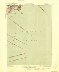
 1943 Boston1943 Print · USGSGreater Boston and its southern suburbs appear here during the mobilization of the early 1940s. Genealogists and historians can trace the early footprints of Commonwealth Airport, military sites like Fort Winthrop, and local institutions such as Pondville State Hospital.
 - 1943 Map of Lowell
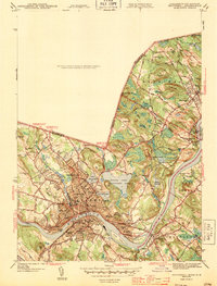
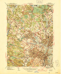
 1943 Lowell1943 Print · USGSCentral New England industrial hubs and rural borderlands are mapped here during the early 1940s. Genealogists can trace family names across Mt Misery, Barrett Hill, and small settlements like Collinsville or North Pelham.
 - 1943 Map of Haverhill
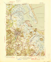
 1943 Haverhill1943 Print · USGSThe Merrimack River valley during the early 1940s reveals a bustling corridor of industry and education between Haverhill and Groveland. Genealogists and historians can trace neighborhood school sites like Hannah Duston Sch and significant cemeteries such as Linwood Cem.2 unique versions available
 - 1943 Map of Boston North
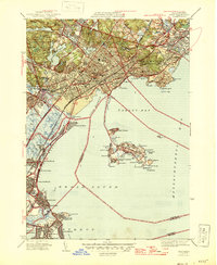
 1943 Boston North1943 Print · USGSGreater Boston's northern suburbs and industrial waterfronts appear in high detail during the early 1940s. Genealogists and historians can trace the limits of neighborhoods like Orient Heights and find landmarks like Tufts College and the Mass Soldiers Home.
 - 1943 Map of Ayers Village
 1943 Ayers Village1943 Print · USGSThe Massachusetts-New Hampshire borderlands are captured here during the Second World War as the suburbs of Haverhill expanded. Genealogists and local historians can trace family-named sites like Grosvenor Corner, Tozier Corner, and the West Parish Ch.2 unique versions available
 - 1943 Map of Cape Ann
 1943 Cape Ann1943 Print · USGSCoastal Massachusetts and New Hampshire appear here during the wartime era, showing the maritime and rail infrastructure that defined the North Shore. Genealogists can trace family names across Asbury Grove, Merrimacport, and the Boston & Maine RR rail corridor.
 - 1943 Map of Lynn
 1943 Lynn1943 Print · USGSThe Massachusetts coastline near the height of the Second World War reveals a landscape heavily shaped by maritime defense and established seaside communities. Researchers can trace the layout of historic harbor defenses like Fort Duvall or locate family landmarks in older settlements such as Beach Bluff, East Saugus, and Germantown.
 - 1944 Map of Lynn
 1944 Lynn1944 Print · USGSCoastal Massachusetts during the mid-forties reveals a world of busy rail lines and seaside neighborhoods from Lynn to Winthrop. Genealogists and historians can trace defunct landmarks like the City Farm, the Black Mine on Nahant, and the sprawling Suffolk Downs Race Track.
 - 1944 Map of South Groveland
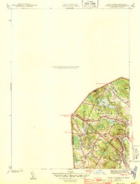
 1944 South Groveland1944 Print · USGSThe northern reaches of the Merrimack Valley are captured here during the mid-1940s, a period when the area's many glacial ponds still anchored small village centers. Genealogists and researchers can trace the roads around Lake Cochichewick or locate family sites near South Groveland and the Brooks School.3 unique versions available
 - 1944 Map of Georgetown
 1944 Georgetown1944 Print · USGSCoastal Massachusetts during the mid-forties reveals a landscape of wooded state forests and traditional village centers. Researchers can trace family roots through Harmony Cem, the halls of Dummer Academy, or along the old Boston and Maine rail line.2 unique versions available
 - 1944 Map of Wilmington
 1944 Wilmington1944 Print · USGSWilmington and its surrounding Middlesex County hamlets are shown during the mid-1940s, a period when the Boston and Maine Railroad still anchored the local economy. Genealogists and researchers can trace family landmarks like the State Infirmary, Wildwood Cem, and rural schoolhouses such as the Shawsheen Sch.2 unique versions available
 - 1944 Map of Salem
 1944 Salem1944 Print · USGSThe North Shore coastline and inland marshes are captured here in the mid-1940s, showing a landscape shaped by maritime trade and early industry. Researchers can trace historic cemeteries and civic landmarks from Derby Wharf to the Old Copper Mine and Danvers State Hospital.3 unique versions available
 - 1944 Map of Lawrence
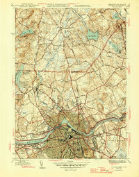
 1944 Lawrence1944 Print · USGSMid-century Lawrence and Andover center this survey of the Merrimack Valley during a period of industrial and academic growth. Genealogists can trace family sites from the Bellevue Cemetery to Phillips Academy and the vanished Town Infirmary.4 unique versions available
 - 1944 Map of Hampton
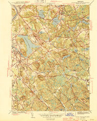
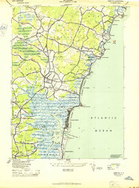 1944 Hampton1944 Print · USGSThe New Hampshire Seacoast during the mid-forties reveals a world of tidal marshes and emerging beach communities. Trace family roots and local history at Old Camp Ground, Dearborn Academy, and the crossroads at The Five Corners.2 unique versions available
 - 1944 Map of Newburyport West
 1944 Newburyport West1944 Print · USGSThe Lower Merrimack Valley at the height of the 1940s reveals a landscape of manufacturing towns and riverside villages. Genealogists can trace family footprints across Union Cem, Bridge Street Cem, and the old neighborhoods of Amesbury and Newburyport.3 unique versions available
 - 1944 Map of Reading
 1944 Reading1944 Print · USGSReading and North Reading are shown here during the height of the Second World War as the region balanced its colonial roots with modern military needs. Researchers can locate the Military Police Camp, historic burial sites like Oakdale Cem, and the tracks of the Boston and Maine RR.2 unique versions available
 - 1945 Map of Rockport
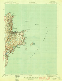 1945 Rockport1945 Print · USGSThe tip of Cape Ann appears here just as the wartime era ended, showing a coastal landscape defined by quarrying roots and maritime necessity. Genealogists and historians can trace the Boston and Main rail line, Beach Grove Cem, and prominent beacons like the Cape Ann Lighthouse.4 unique versions available
 - 1945 Map of Marblehead North
 1945 Marblehead North1945 Print · USGSThe North Shore of Massachusetts during the mid-1940s shows a complex landscape of maritime heritage and rail-connected settlements. Genealogists and local historians can trace the detailed streets of Marblehead and locate landmarks like Central Cemetery and Fort Pickering.3 unique versions available
 - 1945 Map of Newburyport East
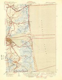 1945 Newburyport East1945 Print · USGSThe Massachusetts and New Hampshire borderlands meet the Atlantic at the height of the war years, showing a landscape defined by tidal rivers and coastal reaches. Genealogists and historians can trace Newbury Old Town, the Newburyport LH, and the CCC Camp near Salisbury.2 unique versions available
 - 1945 Map of Marblehead South
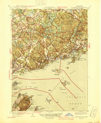
 1945 Marblehead South1945 Print · USGSCoastal Essex County comes to life at the close of the war, showing the intricate shoreline and rail connections of the North Shore. Genealogists and historians can trace the Boston and Maine corridor and locate local landmarks like Castle Rock or the Devereux Beach coastline.3 unique versions available
 - 1945 Map of Ipswich
 1945 Ipswich1945 Print · USGSIpswich and the surrounding Essex County coast are detailed here in the mid-1940s, highlighting a landscape defined by tidal rivers and barrier islands. Genealogists and historians can locate family landmarks such as Heartbreak Hill, the Mount Cem, and the Boston and Maine Railroad corridor.3 unique versions available
 - 1946 Map of Lynn
 1946 Lynn1946 Print · USGSThe Massachusetts North Shore thrives at the end of the war, showcasing the dense neighborhoods of Lynn and the coastal recreation of Revere Beach. Genealogists and historians can locate old landmarks like the Pine Grove Cemetery and the military grounds of Ft Heath.3 unique versions available
 - 1946 Map of Lowell
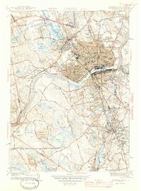
 1946 Lowell1946 Print · USGSPost-war Lowell and its New Hampshire borderlands are captured here during a period of transition for the Merrimack Valley's industrial and rural sectors. Researchers can trace the layout of the Lowell Textile Institute or locate family plots at Gibson Cem and Gumpas Cem.2 unique versions available
 - 1946 Map of Boston North
 1946 Boston North1946 Print · USGSGreater Boston's northern suburbs emerge in the mid-1940s as a hub of industry and academic life. Genealogists and researchers can trace family plots in Woodlawn Cem or locate historic campuses like Tufts College and Radcliffe College.2 unique versions available
Showing maps 1-25 of 32
Top cities of Essex County
- Lynn historical maps
- Lawrence historical maps
- Haverhill historical maps
- Peabody historical maps
- Methuen historical maps
- Salem historical maps
See more
Frequently asked questions
- What are the different types of historical maps available for Essex County?
- What is the oldest map of Essex County?
- Where can I purchase historical maps of Essex County for my home or office?
- Where can I download high-res historical maps of Essex County?
- Are there historical topographic maps available for Essex County?
- Is there historical aerial imagery available for Essex County?
- Where are historical maps of Essex County sourced from?