1950s Maps of Essex County, Massachusetts
Explore 23 historic maps of Essex County from the 1950s. These maps offer a rare glimpse into what life looked like during the 1950s — showing old roads, neighborhoods, homes, and landmarks that have changed or disappeared over time.
Whether you're researching your family's past, planning a metal detecting trip, or studying how Essex County's landscape evolved across the 1950s, these high-resolution maps are a powerful tool for exploring the history of this region.
- Focus on a specific era: All maps on this page are from the 1950s, giving you a focused view of this time period.
- See what’s changed: Compare century-old streets, trails, and buildings to today's modern landscape using overlays and satellite layers.
- Research with precision: Use these maps for genealogy, historical research, land use analysis, or educational projects.
- View, download, or print: Maps are fully viewable online in high resolution, and can be downloaded or printed for your own records.
Start exploring Essex County's history through authentic maps from the 1950s. This is your window into the past.
Essex County, MA maps
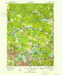
(23)- 1950 Map of Exeter, 1952 Print
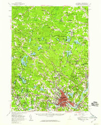
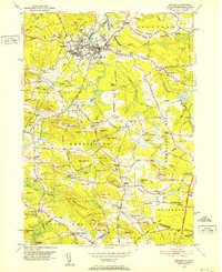 1950 Exeter1952 Print · USGSCoastal New Hampshire's rural character and established town centers are captured here at mid-century, just as local road networks began to expand. Researchers can trace ancestral roots through family-named landmarks like Gooch Corner, Dows Corner, and the Westview Cem.5 unique versions available
 - 1950 Map of Wilmington, 1952 Print
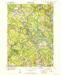 1950 Wilmington1952 Print · USGSWilmington and Tewksbury are shown during a period of significant mid-century growth along the Boston and Maine rail lines. Researchers can trace the sprawling grounds of the State Infirmary and locate vanished local landmarks like the Whitefield Sch and Silver Lake.4 unique versions available
 - 1950 Map of Lowell, 1953 Print
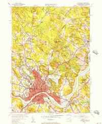
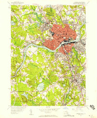
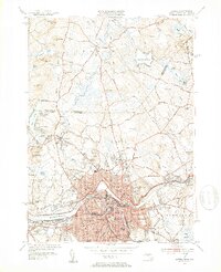 1950 Lowell1953 Print · USGSMid-century Lowell is a bustling center of industry and education at the bend of the Merrimack River. Researchers can trace the era's infrastructure from the Pawtucket Dam to institutions like Keith Academy and the Lowell Textile Institute.4 unique versions available
 - 1950 Map of Ipswich, 1956 Print
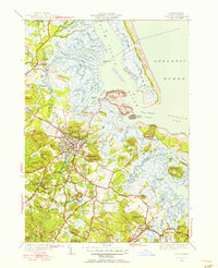 1950 Ipswich1956 Print · USGSCoastal Massachusetts is seen here in the mid-century as a land of expansive salt marshes and historic harbor towns. Genealogists and historians can trace family-named hills and early settlements from Ipswich and Rowley to landmarks like Castle Hill and Nourse Cem.3 unique versions available
 - 1951 Map of Reading, 1952 Print
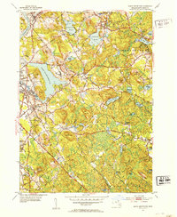
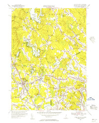
 1951 Reading1952 Print · USGSNorth of Boston in the early fifties, the landscape around Reading and Wakefield shows a mix of growing residential centers and military training grounds. You can trace family roots at Lakeside Cem, locate the old Bachelder Sch, or explore the grounds of Camp Curtis Guild.3 unique versions available
 - 1952 Map of Haverhill, 1953 Print
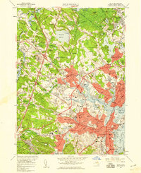
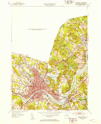 1952 Haverhill1953 Print · USGSHaverhill and the Merrimack River valley are captured in the early fifties, showing a thriving industrial city and its surrounding hill country. Genealogists can locate family names and sites across Bradford Junior College, Whittier Birthplace, and several local schools.2 unique versions available
 - 1952 Map of South Groveland, 1953 Print
 1952 South Groveland1953 Print · USGSIn the early 1950s, this part of Essex County balanced its industrial riverfront heritage with academic and rural growth. Genealogists and researchers can trace the development of North Andover Center, Merrimack College, and the old Brookside Cem among the many named hills and ponds.4 unique versions available
 - 1952 Map of Ayers Village, 1953 Print
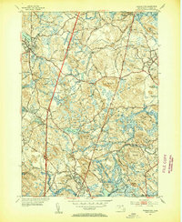
 1952 Ayers Village1953 Print · USGSThe borderlands of Rockingham County and Essex County come into focus in the early fifties as the region's post-war identity took shape. Genealogists and researchers can trace family-named corners and community landmarks like Ayers Village, Tozier Corner, and the Howe Sch.
 - 1952 Map of Newburyport West, 1953 Print
 1952 Newburyport West1953 Print · USGSThe Merrimack River valley in the early fifties shows a landscape of established river towns and growing transit corridors. Genealogists can locate family burial sites at Sawyers Hill Burying Ground or trace the early campus of Governor Dummer Academy.4 unique versions available
 - 1952 Map of Newburyport East, 1954 Print
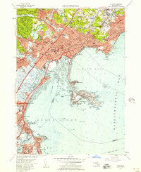
 1952 Newburyport East1954 Print · USGSCoastal Massachusetts and New Hampshire meet at the mouth of the Merrimack River during the early fifties, where maritime commerce and conservation intersect. Researchers can trace ancestral sites at the First Burial Ground or locate vanished landmarks like Butlers Toothpick and Woodbridge Sch.3 unique versions available
 - 1953 Map of Georgetown, 1954 Print
 1953 Georgetown1954 Print · USGSMid-century Essex County is captured here at a time of rural stability and emerging suburban growth. Genealogists and researchers can trace family lands near South Byfield (PO), the historic Dummer Academy, and the Rowley Burial Ground.4 unique versions available
 - 1955 Map of Ayers Village, 1956 Print
 1955 Ayers Village1956 Print · USGSThe New Hampshire-Massachusetts state line comes alive in the 1950s as suburban growth meets traditional landscapes. Researchers can trace family roots at Salem Depot, locate the historic West Parish Ch, and explore landmarks like Rockingham Park.3 unique versions available
 - 1955 Map of Haverhill, 1957 Print
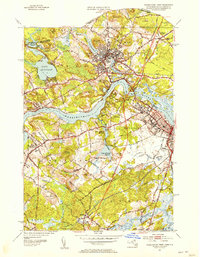
 1955 Haverhill1957 Print · USGSHaverhill and Bradford sit at a crossroads of industry and education along the Merrimack River during the mid-fifties. Researchers can trace the legacy of local institutions like Bradford Junior College, find the Whittier Birthplace, and locate numerous neighborhood schools and cemeteries.2 unique versions available
 - 1955 Map of Lawrence, 1958 Print
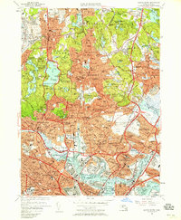
 1955 Lawrence1958 Print · USGSMid-century Lawrence and Andover center on the bustling Merrimack Valley during a period of robust industrial and academic growth. Genealogists and historians can trace the campuses of Phillips Academy, the planned streets of Shawsheen Village, and various local burial sites like Bellevue Cemetery.
 - 1956 Map of Lynn, 1957 Print
 1956 Lynn1957 Print · USGSThe North Shore coastline comes alive in the mid-fifties, from the rocky points of Nahant to the industrial corridors of Lynn. Genealogists and historians can trace family plots in Pine Grove Cemetery or locate military heritage at Fort Ruckman.4 unique versions available
 - 1956 Map of Boston North, 1958 Print
 1956 Boston North1958 Print · USGSThe industrial and residential landscape north of Boston comes alive in the mid-fifties, from the shipyards to the suburban fells. Local historians can trace the extensive rail lines of the B & M Yards and landmark sites like the Bunker Hill Monument and Saugus Race Track.3 unique versions available
 - 1956 Map of Salem, 1959 Print
 1956 Salem1959 Print · USGSThe North Shore region in the mid-fifties shows a fascinating transition from historic coastal centers to growing suburban hubs. Researchers can trace ancestral locations from the Danvers State Hospital to landmarks like the House of Seven Gables and Middleton Colony.2 unique versions available
 - 1956 Map of Haverhill, 1959 Print
 1956 Haverhill1959 Print · USGSMid-century New England comes to life across the New Hampshire and Massachusetts border during this period of significant growth. Genealogists and historians can trace the Whittier Birthplace, numerous local schools like Tilton Sch, and the busy corridors of the Boston and Maine Railroad.3 unique versions available
 - 1956 Map of Marblehead South, 1959 Print
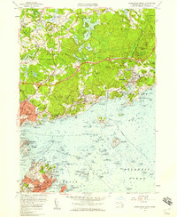
 1956 Marblehead South1959 Print · USGSThe North Shore coastline in the mid-fifties reveals a landscape of maritime tradition and suburban growth. Researchers can trace the development of Marblehead Neck and identify coastal landmarks like Tinkers Island and Star of the Sea Ch.2 unique versions available
 - 1956 Map of Marblehead North, 1959 Print
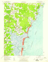
 1956 Marblehead North1959 Print · USGSThe Massachusetts North Shore flourished in the mid-1950s as classic maritime villages like Manchester and Marblehead met the expansion of the State Route 128 corridor. Genealogists and historians can trace the foundations of local institutions like Endicott Jr College, the U.S. Coast Guard Air Station, and the historic Fort Sewell.2 unique versions available
 - 1956 Map of Boston, 1967 Print
 1956 Boston1967 Print · USGSThe Massachusetts coastline and industrial interior are seen here during the mid-century peak of suburban and highway expansion. Researchers can trace historic harbor defenses like Fort Revere, local landmarks such as Faneuil Hall, and the vast Parker River National Wildlife Refuge.6 unique versions available
 - 1957 Map of Hampton, 1959 Print
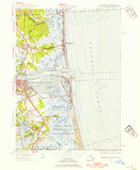
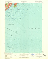
 1957 Hampton1959 Print · USGSCoastal Rockingham County in the late fifties shows a landscape of tidal marshes and growing beach communities. Genealogists and local researchers can locate landmarks like Dearborn Academy, the Boston and Maine RR, and Ring Swamp Cem.5 unique versions available
 - 1958 Map of Boston
 1958 Boston1958 Print · USGSEastern Massachusetts and southern New Hampshire are shown at the height of the industrial era, before the full expansion of the interstate system. Trace coastal defenses at Fort Warren, historic rail lines like the Boston and Maine, and the development of the Mass. 128 corridor.2 unique versions available
End of results
Showing maps 1-23 of 23
Top cities of Essex County
- Lynn historical maps
- Lawrence historical maps
- Haverhill historical maps
- Peabody historical maps
- Methuen historical maps
- Salem historical maps
See more
Frequently asked questions
- What are the different types of historical maps available for Essex County?
- What is the oldest map of Essex County?
- Where can I purchase historical maps of Essex County for my home or office?
- Where can I download high-res historical maps of Essex County?
- Are there historical topographic maps available for Essex County?
- Is there historical aerial imagery available for Essex County?
- Where are historical maps of Essex County sourced from?