1930s Maps of Essex County, Massachusetts
Explore 5 historic maps of Essex County from the 1930s. These maps offer a rare glimpse into what life looked like during the 1930s — showing old roads, neighborhoods, homes, and landmarks that have changed or disappeared over time.
Whether you're researching your family's past, planning a metal detecting trip, or studying how Essex County's landscape evolved across the 1930s, these high-resolution maps are a powerful tool for exploring the history of this region.
- Focus on a specific era: All maps on this page are from the 1930s, giving you a focused view of this time period.
- See what’s changed: Compare century-old streets, trails, and buildings to today's modern landscape using overlays and satellite layers.
- Research with precision: Use these maps for genealogy, historical research, land use analysis, or educational projects.
- View, download, or print: Maps are fully viewable online in high resolution, and can be downloaded or printed for your own records.
Start exploring Essex County's history through authentic maps from the 1930s. This is your window into the past.
Essex County, MA maps
(5)- 1931 Map of Lowell
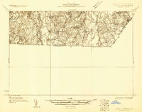 1931 Lowell1931 Print · USGSSouthern New Hampshire and northern Massachusetts met along the river and rail lines in the early thirties. Local researchers can trace family lands near St Marie Convent, the site of Musquash Sch, and the heights of Jeremy Hill.
 - 1932 Map of Newburyport
 1932 Newburyport1932 Print · USGSThe New Hampshire seacoast and southern Rockingham County are shown here in the early thirties, just as coastal recreation and inland farming reached a mature balance. Genealogists can locate family-named landmarks like Nason Corner, Dearborn Academy, and various district schools.4 unique versions available
 - 1934 Map of Exeter
 1934 Exeter1934 Print · USGSThe New Hampshire seacoast and Merrimack Valley met the Atlantic in the mid-thirties as a network of rail and river commerce. Genealogists can trace family lines through Newbury Old Town or locate historic institutions like Phillips Exeter Academy and Dearborn Academy.5 unique versions available
 - 1935 Map of Lowell
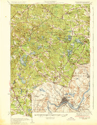
 1935 Lowell1935 Print · USGSGreater Lowell and the Merrimack Valley are captured in the mid-1930s, showing a region defined by its industrial riverfront and extensive rail networks. Researchers can trace historic neighborhoods like Wamesit, local landmarks like St Marie Convent, and early industry at Flat Rock Quarry.3 unique versions available
 - 1935 Map of Haverhill
 1935 Haverhill1935 Print · USGSThe borderlands of New Hampshire and Massachusetts appear here in the mid-1930s, showing a landscape defined by the Merrimack River and a dense rail network. Genealogists can trace family landmarks like Philbrick Hill or locate old schoolhouses including South Road Sch and the Depot Sch.5 unique versions available
End of results
Showing maps 1-5 of 5
Top cities of Essex County
- Lynn historical maps
- Lawrence historical maps
- Haverhill historical maps
- Peabody historical maps
- Methuen historical maps
- Salem historical maps
See more
Frequently asked questions
- What are the different types of historical maps available for Essex County?
- What is the oldest map of Essex County?
- Where can I purchase historical maps of Essex County for my home or office?
- Where can I download high-res historical maps of Essex County?
- Are there historical topographic maps available for Essex County?
- Is there historical aerial imagery available for Essex County?
- Where are historical maps of Essex County sourced from?