1931 Map of Lowell
USGS Topo · Published 1931About this map
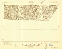
The Merrimack River dominates the western edge of this 1931 survey, cutting a path through the landscape near Nashua and providing the industrial lifeline for the region. To the east, the rural character of Pelham is defined by a network of waterways including Beaver Brook and Gumpus Pond, where small schools like School No 5 served the outlying population. The Boston and Maine Railroad follows the river's curve, marking the critical transportation corridor of the early 1930s.
Find a feature on this map
27 named features on this map. Tap any name to fly to it.
Don’t see what you’re looking for? This feature index may not catch every label — zoom into the map to look around manually.
Map Details
Editions of this 1931 Lowell Map
This is the sole edition of this map. No revisions or reprints were ever made.
Other maps of this area

1886 · Lawrence
USGS Topo · 1:62,500

1886 · Lowell
USGS Topo · 1:62,500

1888 · Haverhill
USGS Topo · 1:62,500

1888 · Lawrence
USGS Topo · 1:62,500

1890 · Haverhill
USGS Topo · 1:62,500

1893 · Lowell
USGS Topo · 1:62,500

1893 · Lawrence
USGS Topo · 1:62,500

1893 · Haverhill
USGS Topo · 1:62,500

1893 · Groton
USGS Topo · 1:62,500

1905 · Manchester
USGS Topo · 1:62,500