1950s Maps of Methuen, Massachusetts
Explore 10 historic maps of Methuen from the 1950s. These maps offer a rare glimpse into what life looked like during the 1950s — showing old roads, neighborhoods, homes, and landmarks that have changed or disappeared over time.
Whether you're researching your family's past, planning a metal detecting trip, or studying how Methuen's landscape evolved across the 1950s, these high-resolution maps are a powerful tool for exploring the history of this region.
- Focus on a specific era: All maps on this page are from the 1950s, giving you a focused view of this time period.
- See what’s changed: Compare century-old streets, trails, and buildings to today's modern landscape using overlays and satellite layers.
- Research with precision: Use these maps for genealogy, historical research, land use analysis, or educational projects.
- View, download, or print: Maps are fully viewable online in high resolution, and can be downloaded or printed for your own records.
Start exploring Methuen's history through authentic maps from the 1950s. This is your window into the past.
Methuen, MA maps
(10)- 1950 Map of Lowell, 1953 Print
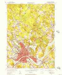
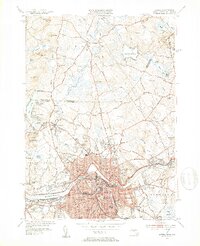 1950 Lowell1953 Print · USGSMid-century Lowell is a bustling center of industry and education at the bend of the Merrimack River. Researchers can trace the era's infrastructure from the Pawtucket Dam to institutions like Keith Academy and the Lowell Textile Institute.4 unique versions available
 - 1952 Map of Haverhill, 1953 Print
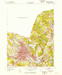 1952 Haverhill1953 Print · USGSHaverhill and the Merrimack River valley are captured in the early fifties, showing a thriving industrial city and its surrounding hill country. Genealogists can locate family names and sites across Bradford Junior College, Whittier Birthplace, and several local schools.2 unique versions available
 - 1952 Map of South Groveland, 1953 Print
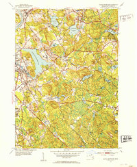 1952 South Groveland1953 Print · USGSIn the early 1950s, this part of Essex County balanced its industrial riverfront heritage with academic and rural growth. Genealogists and researchers can trace the development of North Andover Center, Merrimack College, and the old Brookside Cem among the many named hills and ponds.4 unique versions available
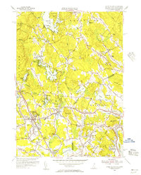
 - 1952 Map of Ayers Village, 1953 Print
 1952 Ayers Village1953 Print · USGSThe borderlands of Rockingham County and Essex County come into focus in the early fifties as the region's post-war identity took shape. Genealogists and researchers can trace family-named corners and community landmarks like Ayers Village, Tozier Corner, and the Howe Sch.
 - 1955 Map of Ayers Village, 1956 Print
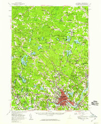
 1955 Ayers Village1956 Print · USGSThe New Hampshire-Massachusetts state line comes alive in the 1950s as suburban growth meets traditional landscapes. Researchers can trace family roots at Salem Depot, locate the historic West Parish Ch, and explore landmarks like Rockingham Park.3 unique versions available
 - 1955 Map of Haverhill, 1957 Print
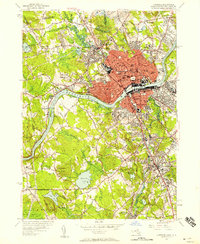
 1955 Haverhill1957 Print · USGSHaverhill and Bradford sit at a crossroads of industry and education along the Merrimack River during the mid-fifties. Researchers can trace the legacy of local institutions like Bradford Junior College, find the Whittier Birthplace, and locate numerous neighborhood schools and cemeteries.2 unique versions available
 - 1955 Map of Lawrence, 1958 Print
 1955 Lawrence1958 Print · USGSMid-century Lawrence and Andover center on the bustling Merrimack Valley during a period of robust industrial and academic growth. Genealogists and historians can trace the campuses of Phillips Academy, the planned streets of Shawsheen Village, and various local burial sites like Bellevue Cemetery.
 - 1956 Map of Haverhill, 1959 Print
 1956 Haverhill1959 Print · USGSMid-century New England comes to life across the New Hampshire and Massachusetts border during this period of significant growth. Genealogists and historians can trace the Whittier Birthplace, numerous local schools like Tilton Sch, and the busy corridors of the Boston and Maine Railroad.3 unique versions available
 - 1956 Map of Boston, 1967 Print
 1956 Boston1967 Print · USGSThe Massachusetts coastline and industrial interior are seen here during the mid-century peak of suburban and highway expansion. Researchers can trace historic harbor defenses like Fort Revere, local landmarks such as Faneuil Hall, and the vast Parker River National Wildlife Refuge.6 unique versions available
 - 1958 Map of Boston
 1958 Boston1958 Print · USGSEastern Massachusetts and southern New Hampshire are shown at the height of the industrial era, before the full expansion of the interstate system. Trace coastal defenses at Fort Warren, historic rail lines like the Boston and Maine, and the development of the Mass. 128 corridor.2 unique versions available
End of results
Showing maps 1-10 of 10
Top cities near Methuen
- Manchester historical maps
- Lowell historical maps
- Lynn historical maps
- Lawrence historical maps
- Haverhill historical maps
- Peabody historical maps
See more
Top neighborhoods of Methuen
- Graceland Park historical maps
- Grosvenor Corner historical maps
- Maple Park historical maps
- Tozier Corner historical maps
- Cook's Corner historical maps
- Marsh Corner historical maps
See more
Frequently asked questions
- What are the different types of historical maps available for Methuen?
- What is the oldest map of Methuen?
- Where can I purchase historical maps of Methuen for my home or office?
- Where can I download high-res historical maps of Methuen?
- Are there historical topographic maps available for Methuen?
- Is there historical aerial imagery available for Methuen?
- Where are historical maps of Methuen sourced from?