Old Maps of Peabody, Massachusetts for Genealogy
Trace your family roots with 56 historic maps of Peabody. These high-res maps reveal old neighborhoods, homesites, landmarks, and streets — helping you uncover where your ancestors lived and how the area evolved over time.
- Explore historic neighborhoods: Identify where your relatives may have lived in the 1800s or 1900s.
- Compare maps over time: Trace the changes in streets, buildings, and landmarks for multi-generational research.
- Perfect for genealogy & ancestry research: Used by family historians and researchers to map out lineage and migration.
These maps are an incredible resource for exploring your personal connection to Peabody's past.
Peabody, MA maps
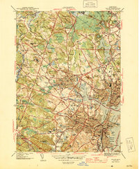
(56)- 1886 Map of Lawrence
 1886 Lawrence1886 Print · USGSThe Merrimack Valley at the close of the nineteenth century was a bustling hub of industry and transit. Researchers can trace ancestral roots through vanished hamlets like Frye Village, locate the original Andover Theological Seminary, and follow the old Salem and Lawrence Railroad line.
 - 1888 Map of Lawrence
 1888 Lawrence1888 Print · USGSThe Merrimack Valley industrial corridor is captured here in the late nineteenth century as a thriving rail and textile hub. Researchers can trace the footprints of the Andover Theological Seminary, locate the State Almshouse, and follow the iron tracks through Ballardvale.
 - 1888 Map of Salem
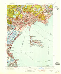
 1888 Salem1888 Print · USGSThe North Shore in the late nineteenth century is captured here in its era of peak rail development. Genealogists and historians can trace family-named sites like Doles Corner and institutions such as Dummer Academy or the Insane Asylum.
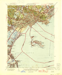
 - 1892 Map of Boston Bay
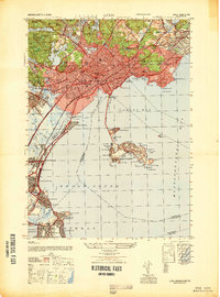
 1892 Boston Bay1892 Print · USGSThe outer harbor and North Shore coastline are captured in the late Victorian era, before modern development reshaped the beaches and islands. Genealogists and maritime historians can trace the early rail lines to Revere Beach or locate historic defenses like Fort Warren and the iconic Boston Light.4 unique versions available
 - 1893 Map of Salem
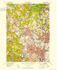
 1893 Salem1893 Print · USGSCoastal Massachusetts at the end of the nineteenth century reveals a landscape defined by industrial rail lines and ancient marshlands. Genealogists and historians can trace family-named hills and early institutional sites like Dummer Academy, the Insane Asylum, and the Ipswich Light.11 unique versions available
 - 1893 Map of Lawrence
 1893 Lawrence1893 Print · USGSThe Merrimac River valley and its surrounding textile and rail hubs are captured here at their industrial peak during the 1880s. Genealogists can trace family footprints through the State Almshouse, the Andover Theological Seminary, and vanished stops like Burtts Crossing Station.10 unique versions available
 - 1903 Map of Boston Bay
 1903 Boston Bay1903 Print · USGSThe Massachusetts North and South Shores are seen here at the turn of the century as a hub of rail-connected maritime life. You can trace the path of old rail divisions to historic coastal landings at Point of Pines, Marblehead, and the naval defenses at Ft. Warren.9 unique versions available
 - 1917 Map of Salem
 1917 Salem1917 Print · USGSCoastal Massachusetts at the end of the Great War reveals a landscape of maritime commerce and rail-connected villages. Trace the local economy from Salem Harbor to Ipswich Light, or locate historic sites like Dummer Academy and the Insane Asylum.
 - 1918 Map of Lawrence
 1918 Lawrence1918 Print · USGSGreater Lawrence and the Merrimac Valley are captured here during the late First World War era, showing a landscape defined by industrial rail and historic village centers. Researchers can trace the sprawling Boston and Maine Railroad network to specific sites like the State Almshouse or the Andover Theological Seminary.2 unique versions available
 - 1919 Map of Salem
 1919 Salem1919 Print · USGSThe North Shore and its rail-connected towns are captured here during the height of the steam era. Genealogists and historians can trace the local landscape through landmarks like Dummer Academy, the Insane Asylum, and the vanished Box Factory.2 unique versions available
 - 1943 Map of Lowell
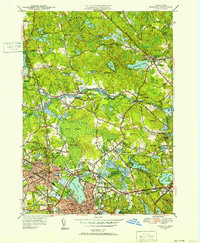
 1943 Lowell1943 Print · USGSCentral New England industrial hubs and rural borderlands are mapped here during the early 1940s. Genealogists can trace family names across Mt Misery, Barrett Hill, and small settlements like Collinsville or North Pelham.
 - 1943 Map of Cape Ann
 1943 Cape Ann1943 Print · USGSCoastal Massachusetts and New Hampshire appear here during the wartime era, showing the maritime and rail infrastructure that defined the North Shore. Genealogists can trace family names across Asbury Grove, Merrimacport, and the Boston & Maine RR rail corridor.
 - 1943 Map of Lynn
 1943 Lynn1943 Print · USGSThe Massachusetts coastline near the height of the Second World War reveals a landscape heavily shaped by maritime defense and established seaside communities. Researchers can trace the layout of historic harbor defenses like Fort Duvall or locate family landmarks in older settlements such as Beach Bluff, East Saugus, and Germantown.
 - 1944 Map of Lynn
 1944 Lynn1944 Print · USGSCoastal Massachusetts during the mid-forties reveals a world of busy rail lines and seaside neighborhoods from Lynn to Winthrop. Genealogists and historians can trace defunct landmarks like the City Farm, the Black Mine on Nahant, and the sprawling Suffolk Downs Race Track.
 - 1944 Map of Salem
 1944 Salem1944 Print · USGSThe North Shore coastline and inland marshes are captured here in the mid-1940s, showing a landscape shaped by maritime trade and early industry. Researchers can trace historic cemeteries and civic landmarks from Derby Wharf to the Old Copper Mine and Danvers State Hospital.3 unique versions available
 - 1944 Map of Reading
 1944 Reading1944 Print · USGSReading and North Reading are shown here during the height of the Second World War as the region balanced its colonial roots with modern military needs. Researchers can locate the Military Police Camp, historic burial sites like Oakdale Cem, and the tracks of the Boston and Maine RR.2 unique versions available
 - 1946 Map of Lynn
 1946 Lynn1946 Print · USGSThe Massachusetts North Shore thrives at the end of the war, showcasing the dense neighborhoods of Lynn and the coastal recreation of Revere Beach. Genealogists and historians can locate old landmarks like the Pine Grove Cemetery and the military grounds of Ft Heath.3 unique versions available
 - 1947 Map of Lynn
 1947 Lynn1947 Print · USGSThe North Shore of Massachusetts thrives in the late 1940s, from the industrial heart of Lynn to the rocky heights of Nahant. Genealogists and historians can trace neighborhood developments near Pine Grove Cemetery, explore the grounds of the City Farm, or locate the historic Black Mine.
 - 1948 Map of Boston
 1948 Boston1948 Print · USGSEastern Massachusetts and southern New Hampshire appear at an industrial peak in the late 1940s, just as suburban growth began to accelerate. Genealogists and historians can trace rail lines like the Boston and Albany RR or locate coastal landmarks like Graves Lighthouse and Fort Devens.2 unique versions available
 - 1949 Map of Salem, 1952 Print
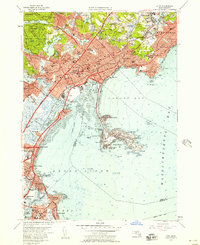
 1949 Salem1952 Print · USGSThe North Shore of Massachusetts thrives in the late 1940s, balancing a dense industrial core with sprawling institutional campuses and historic maritime sites. Local historians can trace the rail junctions at West Peabody Junction and find ancestral landmarks like Harmony Grove Cem or Hathorne.2 unique versions available
 - 1949 Map of Lynn, 1955 Print
 1949 Lynn1955 Print · USGSThe North Shore coastline comes alive in the late 1940s, showing the dense rail-and-road network connecting Lynn and Swampscott. Researchers can trace old neighborhood boundaries, family cemeteries like Pine Grove Cemetery, and early airport development at Logan International Airport.
 - 1951 Map of Reading, 1952 Print
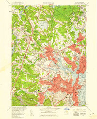
 1951 Reading1952 Print · USGSNorth of Boston in the early fifties, the landscape around Reading and Wakefield shows a mix of growing residential centers and military training grounds. You can trace family roots at Lakeside Cem, locate the old Bachelder Sch, or explore the grounds of Camp Curtis Guild.3 unique versions available
 - 1956 Map of Lynn, 1957 Print
 1956 Lynn1957 Print · USGSThe North Shore coastline comes alive in the mid-fifties, from the rocky points of Nahant to the industrial corridors of Lynn. Genealogists and historians can trace family plots in Pine Grove Cemetery or locate military heritage at Fort Ruckman.4 unique versions available
 - 1956 Map of Salem, 1959 Print
 1956 Salem1959 Print · USGSThe North Shore region in the mid-fifties shows a fascinating transition from historic coastal centers to growing suburban hubs. Researchers can trace ancestral locations from the Danvers State Hospital to landmarks like the House of Seven Gables and Middleton Colony.2 unique versions available
 - 1956 Map of Boston, 1967 Print
 1956 Boston1967 Print · USGSThe Massachusetts coastline and industrial interior are seen here during the mid-century peak of suburban and highway expansion. Researchers can trace historic harbor defenses like Fort Revere, local landmarks such as Faneuil Hall, and the vast Parker River National Wildlife Refuge.6 unique versions available
Showing maps 1-25 of 56
Top cities near Peabody
- Boston historical maps
- Cambridge historical maps
- Quincy historical maps
- Lynn historical maps
- Newton historical maps
- Lawrence historical maps
See more
Top neighborhoods of Peabody
- West Peabody historical maps
- Proctor historical maps
- South Peabody historical maps
- Needham Corner historical maps
Frequently asked questions
- What are the different types of historical maps available for Peabody?
- What is the oldest map of Peabody?
- Where can I purchase historical maps of Peabody for my home or office?
- Where can I download high-res historical maps of Peabody?
- Are there historical topographic maps available for Peabody?
- Is there historical aerial imagery available for Peabody?
- Where are historical maps of Peabody sourced from?