1990s Maps of Gill, Massachusetts
Explore 5 historic maps of Gill from the 1990s. These maps offer a rare glimpse into what life looked like during the 1990s — showing old roads, neighborhoods, homes, and landmarks that have changed or disappeared over time.
Whether you're researching your family's past, planning a metal detecting trip, or studying how Gill's landscape evolved across the 1990s, these high-resolution maps are a powerful tool for exploring the history of this region.
- Focus on a specific era: All maps on this page are from the 1990s, giving you a focused view of this time period.
- See what’s changed: Compare century-old streets, trails, and buildings to today's modern landscape using overlays and satellite layers.
- Research with precision: Use these maps for genealogy, historical research, land use analysis, or educational projects.
- View, download, or print: Maps are fully viewable online in high resolution, and can be downloaded or printed for your own records.
Start exploring Gill's history through authentic maps from the 1990s. This is your window into the past.
Gill, MA maps
(5)- 1990 Map of Northfield
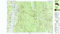 1990 Northfield1990 Print · USGSThe tri-state border of Massachusetts, New Hampshire, and Vermont comes into focus in the 1990s as a landscape of river valleys and forested peaks. Researchers can trace the grounds of the Northfield Mt Hermon School or locate old burial sites like South Parish Cem and Center Cem.2 unique versions available
 - 1990 Map of Bernardston
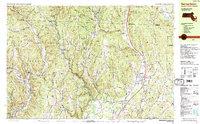 1990 Bernardston1990 Print · USGSFranklin County and the Vermont borderlands appear in the early nineties as a blend of Colonial frontier sites and industrial river hamlets. Researchers can locate historic fortifications like Fort Morrison (Site), rural schools like Leyden Sch, and family-named cemeteries such as Grove Cem.2 unique versions available
 - 1990 Map of Orange
 1990 Orange1990 Print · USGSFranklin County's river valleys and state forests are meticulously detailed in the late twentieth century, showing the intersection of industry and nature. Genealogists can locate family burial sites at Dry Hill Cem and Wilbur Cem or trace the path of the Boston and Maine RR.2 unique versions available
 - 1990 Map of Greenfield
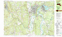 1990 Greenfield1990 Print · USGSUpper Massachusetts in the early nineties reveals a landscape of river-powered industry and prestigious academies. Genealogists and historians can trace family plots at Old Albany Cem or locate the sprawling campuses of Bement Sch and Greenfield Community College.3 unique versions available
 - 1998 Map of Bernardston, 2000 Print
 1998 Bernardston2000 Print · USGSThe hill country of Franklin County at the turn of the millennium shows a landscape of river-valley settlements and upland forests. Genealogists can locate family landmarks like Chandler Hill Cem, the Leyden Sch, and the riverside industrial hamlets of Foundry Village and Griswoldville.
End of results
Showing maps 1-5 of 5
Top cities near Gill
- Amherst historical maps
- Greenfield historical maps
- Montague historical maps
- Orange historical maps
- Brattleboro historical maps
- Swanzey historical maps
See more
Top neighborhoods of Gill
Frequently asked questions
- What are the different types of historical maps available for Gill?
- What is the oldest map of Gill?
- Where can I purchase historical maps of Gill for my home or office?
- Where can I download high-res historical maps of Gill?
- Are there historical topographic maps available for Gill?
- Is there historical aerial imagery available for Gill?
- Where are historical maps of Gill sourced from?