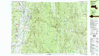
1990 Map of Northfield
USGS Topo · Published 1990About this map
The Connecticut River defines the western valley of this landscape, separating the settlement of Northfield from the dramatic rises of Satans Kingdom and Mt Hermon. This map reveals a region deeply tied to its academic and spiritual institutions, most notably the Northfield Mt Hermon School and the nearby Linden Hill Sch. The river serves as a primary geographical anchor, with the Central Vermont RR tracing its banks and serving stops like Mt Hermon Station and East Northfield Station, underscoring the importance of rail transit in connecting these rural Massachusetts and New Hampshire border towns.
Find a feature on this map
107 named features on this map. Tap any name to fly to it.
Don’t see what you’re looking for? This feature index may not catch every label — zoom into the map to look around manually.
Map Details
Editions of this 1990 Northfield Map
2 editions found
Other maps of this area

1887 · Warwick
USGS Topo · 1:62,500

1887 · Winchendon
USGS Topo · 1:62,500

1889 · Warwick
USGS Topo · 1:62,500

1890 · Greenfield
USGS Topo · 1:62,500

1890 · Winchendon
USGS Topo · 1:62,500

1891 · Brattleboro
USGS Topo · 1:62,500

1893 · Brattleboro
USGS Topo · 1:62,500

1894 · Winchendon
USGS Topo · 1:62,500

1894 · Greenfield
USGS Topo · 1:62,500

1894 · Warwick
USGS Topo · 1:62,500