1940s Maps of Chicopee, Massachusetts
Explore 5 historic maps of Chicopee from the 1940s. These maps offer a rare glimpse into what life looked like during the 1940s — showing old roads, neighborhoods, homes, and landmarks that have changed or disappeared over time.
Whether you're researching your family's past, planning a metal detecting trip, or studying how Chicopee's landscape evolved across the 1940s, these high-resolution maps are a powerful tool for exploring the history of this region.
- Focus on a specific era: All maps on this page are from the 1940s, giving you a focused view of this time period.
- See what’s changed: Compare century-old streets, trails, and buildings to today's modern landscape using overlays and satellite layers.
- Research with precision: Use these maps for genealogy, historical research, land use analysis, or educational projects.
- View, download, or print: Maps are fully viewable online in high resolution, and can be downloaded or printed for your own records.
Start exploring Chicopee's history through authentic maps from the 1940s. This is your window into the past.
Chicopee, MA maps
(5)- 1943 Map of Holyoke
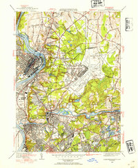
 1943 Holyoke1943 Print · USGSThe Pioneer Valley and the eastern Berkshires are captured here in the early 1940s, showing a robust network of river-side industry and hill-country forests. Researchers can locate vanished landmarks and institutional grounds like Northampton State Hospital, Barnes Airport, and the Nat Gd Rifle Range.
 - 1944 Map of Springfield South, 1954 Print
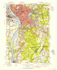 1944 Springfield South1954 Print · USGSGreater Springfield and the lower Connecticut River valley are captured here in the mid-1940s, showing a robust mix of industrial city centers and expanding southern suburbs. Trace local history through landmarks like the US Armory, the Osborn Prison Farm, and the historic Winchester Square.4 unique versions available
 - 1946 Map of Springfield South
 1946 Springfield South1946 Print · USGSThe Connecticut River valley thrives in the mid-1940s, transitioning from the industrial bustle of Springfield to the emerging suburbs of Longmeadow and Enfield. Genealogists and historians can trace institutional landmarks like the U S Armory, St Michaels Cemetery, and the Osborn Prison Farm.2 unique versions available
 - 1946 Map of Springfield North, 1954 Print
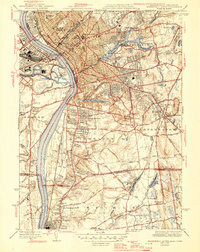
 1946 Springfield North1954 Print · USGSThe Pioneer Valley underwent significant industrial and military growth in the mid-1940s as urbanization reached outward from the riverbanks. Researchers can trace the development of Westover Field or locate family sites near St Aloysius Cem and St Stanislaus Ch.3 unique versions available
 - 1948 Map of Albany, 1951 Print
 1948 Albany1951 Print · USGSThe Hudson and Connecticut River valleys are captured here in the late 1940s, showing the vital rail and water corridors of the Northeast. You can trace the Boston and Maine tracks past Mt Greylock or locate early settlements like Great Barrington and Bennington.
End of results
Showing maps 1-5 of 5
Top cities near Chicopee
- Springfield historical maps
- Enfield historical maps
- Westfield historical maps
- Holyoke historical maps
- Amherst historical maps
- Northampton historical maps
See more
Top neighborhoods of Chicopee
- Chicopee Falls historical maps
- Fairview historical maps
- Sandy Hill historical maps
- Willimansett historical maps
- North Chicopee historical maps
- Aldenville historical maps
See more
Frequently asked questions
- What are the different types of historical maps available for Chicopee?
- What is the oldest map of Chicopee?
- Where can I purchase historical maps of Chicopee for my home or office?
- Where can I download high-res historical maps of Chicopee?
- Are there historical topographic maps available for Chicopee?
- Is there historical aerial imagery available for Chicopee?
- Where are historical maps of Chicopee sourced from?