Old Maps of Springfield Street Historic District, Chicopee for Hiking & Exploration
Hike through history with 26 historic maps of Springfield Street Historic District. Explore old trails, ghost towns, and forgotten backroads — perfect for outdoor adventurers and local explorers.
- Rediscover forgotten places: Map out old mining camps, roads, and footpaths that no longer exist on modern maps.
- Layer with modern tools: Combine with LiDAR or satellite views to plan hikes through historical terrain.
- Made for exploration: Popular among hikers, overlanders, and local history lovers.
Use these maps to find adventure and explore the hidden past of Springfield Street Historic District.
Springfield Street Historic District, Chicopee maps
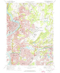
(26)- 1886 Map of Springfield
 1886 Springfield1886 Print · USGSThe Connecticut River valley thrives as a rail and industrial powerhouse at the end of the nineteenth century. Genealogists and researchers can trace local families and industry in hubs like Chicopee Falls, Ireland Parish, and the growing streetscapes of Brightwood.
 - 1889 Map of Springfield
 1889 Springfield1889 Print · USGSThe Connecticut River valley thrives as an industrial powerhouse in the 1880s, fueled by a dense network of water power and rail. Genealogists and historians can trace the foundations of Holyoke and Springfield, or find smaller settlements like Baptist Village and Mittineague.
 - 1893 Map of Springfield
 1893 Springfield1893 Print · USGSThe Pioneer Valley at the end of the nineteenth century centers on the bustling riverfronts of Springfield and Holyoke. Genealogists and historians can trace the rail-connected neighborhoods of Indian Orchard, the distinct Shakers settlement, and early industries along the Chicopee River.
 - 1895 Map of Springfield
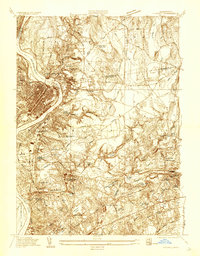
 1895 Springfield1895 Print · USGSThe Connecticut River valley thrives in the late 1800s as a powerhouse of rail-side industry and varied agricultural settlements. Researchers can trace the early layouts of Ireland Parish, the Shaker community, and the mills of Chicopee Falls.11 unique versions available
 - 1896 Map of Holyoke
 1896 Holyoke1896 Print · USGSThe Pioneer Valley and the eastern Berkshire foothills thrive in the 1890s as a complex network of industrial towns and upland farming communities. Historians can trace early infrastructure through the Bisbee Mill, the Agricultural College, and the prominent Ox Bow on the Connecticut River.
 - 1897 Map of Holyoke
 1897 Holyoke1897 Print · USGSThe Pioneer Valley and surrounding highlands thrive in the 1890s, caught here at the height of the region's industrial and agricultural development. Genealogists and historians can trace family roots through dozens of hill towns and river settlements, from Agricultural College in Amherst to the mills of Holyoke and the remote tracks of the Athol Br. R. R..
 - 1901 Map of Holyoke
 1901 Holyoke1901 Print · USGSThe Pioneer Valley and surrounding highlands thrive at the turn of the century, showing a landscape defined by mill towns and early rail networks. Genealogists and historians can trace old homesteads and local landmarks like Bisbee Mill, South Ferry, and the Agricultural College.4 unique versions available
 - 1920 Map of Springfield
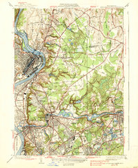
 1920 Springfield1920 Print · USGSGreater Springfield and the Pioneer Valley are captured here during a period of intense industrial and rail expansion. Genealogists and local historians can trace the foundations of neighborhoods like Indian Orchard, locate the Shaker Sta, or study the early rail alignments of the Boston and Albany RR.
 - 1933 Map of Chicopee
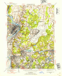
 1933 Chicopee1933 Print · USGSThe industrial corridor of the Pioneer Valley is frozen in time during the early 1930s, showing the dense mill and residential centers along the river bends. Trace local family history through numerous landmarks like St Patrick Cem, the West Street Sch, and the grounds of the Springfield Airport.
 - 1938 Map of Springfield North
 1938 Springfield North1938 Print · USGSThe industrial corridor of the Connecticut River comes alive in this pre-war survey, showcasing the canal-driven growth of Holyoke and Chicopee. Genealogists can trace family roots through sites like St Stanislaus Cem or the localized neighborhoods of Aldenville and South Hadley Falls.4 unique versions available
 - 1943 Map of Holyoke
 1943 Holyoke1943 Print · USGSThe Pioneer Valley and the eastern Berkshires are captured here in the early 1940s, showing a robust network of river-side industry and hill-country forests. Researchers can locate vanished landmarks and institutional grounds like Northampton State Hospital, Barnes Airport, and the Nat Gd Rifle Range.
 - 1946 Map of Springfield North, 1954 Print
 1946 Springfield North1954 Print · USGSThe Pioneer Valley underwent significant industrial and military growth in the mid-1940s as urbanization reached outward from the riverbanks. Researchers can trace the development of Westover Field or locate family sites near St Aloysius Cem and St Stanislaus Ch.3 unique versions available
 - 1948 Map of Albany, 1951 Print
 1948 Albany1951 Print · USGSThe Hudson and Connecticut River valleys are captured here in the late 1940s, showing the vital rail and water corridors of the Northeast. You can trace the Boston and Maine tracks past Mt Greylock or locate early settlements like Great Barrington and Bennington.
 - 1956 Map of Albany, 1968 Print
 1956 Albany1968 Print · USGSThe industrial heart of the Northeast is revealed in the mid-1950s, from the Hudson Valley to the Connecticut River. Researchers can trace the legacy of the Quabbin Reservoir, locate Westover Air Force Base, or follow the Rutland RR through the Green Mountains.2 unique versions available
 - 1957 Map of Albany
 1957 Albany1957 Print · USGSThe Tri-State region and Connecticut River Valley are captured here during a period of significant postwar growth and infrastructure expansion. Genealogists and historians can trace the rail-and-river economy through landmarks like the Boston and Maine railroad, Quabbin Reservoir, and Westover Air Force Base.
 - 1958 Map of Springfield North, 1961 Print
 1958 Springfield North1961 Print · USGSGreater Springfield and Holyoke are shown at the height of the mid-century industrial era, shortly after the turnpike's completion. Genealogists can trace family landmarks and schools like Elms College, St Roses Cem, and the massive Westover Air Force Base.2 unique versions available
 - 1959 Map of Albany
 1959 Albany1959 Print · USGSThe Hudson and Connecticut River valleys are captured here during the late fifties, showing the region's dense rail networks and massive water projects. Researchers can trace the New York State Thruway or locate local landmarks like Mt Greylock and the Quabbin Reservoir.
 - 1962 Map of Albany
 1962 Albany1962 Print · USGSThe Hudson and Connecticut River valleys meet the Green Mountains and Berkshires in this mid-century overview of the Northeast. Genealogists and historians can trace the industrial hearts of Albany and Springfield or locate features like Quabbin Reservoir and Westover Air Force Base.
 - 1972 Map of Springfield North, 1974 Print
 1972 Springfield North1974 Print · USGSGreater Springfield and the Pioneer Valley come into focus in the early 1970s, showing the intersection of river-powered industry and mid-century military growth. Researchers can trace historic cemeteries like Notre Dame Cemetery, local schools, and the massive footprint of Westover Air Force Base.3 unique versions available
 - 1975 Map of Springfield North, 1981 Print
 1975 Springfield North1981 Print · USGSMassachusetts’ Pioneer Valley appears in striking aerial detail during the mid-seventies, showing the industrial density of the Connecticut River towns. Trace the historic streetscapes of Holyoke and Chicopee or the rural-suburban edges of Scott Corners.
 - 1985 Map of Holyoke, 1986 Print
 1985 Holyoke1986 Print · USGSThe Pioneer Valley and surrounding uplands appear here in the mid-eighties, showing a landscape defined by the Connecticut River and modern highway expansion. Genealogists and historians can trace rail lines like the Central Vermont Railway and locate regional landmarks from Mount Tom State Reservation to the Quabbin Reservoir.2 unique versions available
 - 2012 Map of Springfield North, 2012 Print
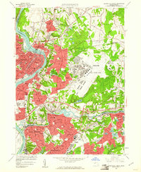
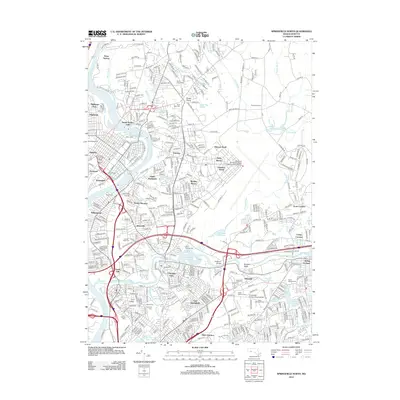 2012 Springfield North2012 Print · USGSCovers Springfield Street Historic District, including Springfield, Chicopee, and other nearby areas
 - 2015 Map of Springfield North, 2015 Print
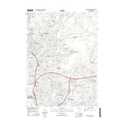 2015 Springfield North2015 Print · USGSCovers Springfield Street Historic District, including Springfield, Chicopee, and other nearby areas
 - 2018 Map of Springfield North, 2018 Print
 2018 Springfield North2018 Print · USGSCovers Springfield Street Historic District, including Springfield, Chicopee, and other nearby areas
 - 2021 Map of Springfield North, 2021 Print
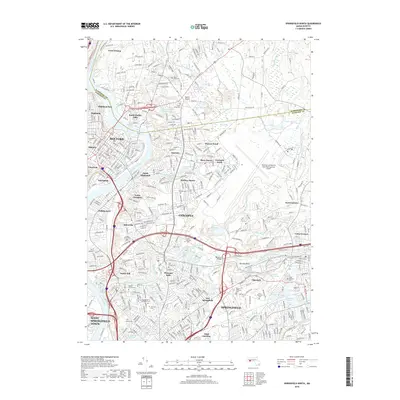
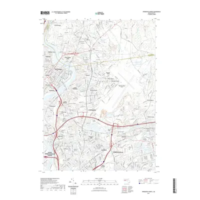 2021 Springfield North2021 Print · USGSCovers Springfield Street Historic District, including Springfield, Chicopee, and other nearby areas
Showing maps 1-25 of 26
Frequently asked questions
- What are the different types of historical maps available for Springfield Street Historic District?
- What is the oldest map of Springfield Street Historic District?
- Where can I purchase historical maps of Springfield Street Historic District for my home or office?
- Where can I download high-res historical maps of Springfield Street Historic District?
- Are there historical topographic maps available for Springfield Street Historic District?
- Is there historical aerial imagery available for Springfield Street Historic District?
- Where are historical maps of Springfield Street Historic District sourced from?