1900s (20th Century) Maps of East Longmeadow, Massachusetts
Explore 27 historic maps of East Longmeadow from the 1900s (20th Century). These maps offer a rare glimpse into what life looked like during the 1900s — showing old roads, neighborhoods, homes, and landmarks that have changed or disappeared over time.
Whether you're researching your family's past, planning a metal detecting trip, or studying how East Longmeadow's landscape evolved across the 1900s, these high-resolution maps are a powerful tool for exploring the history of this region.
- Focus on a specific era: All maps on this page are from the 1900s, giving you a focused view of this time period.
- See what’s changed: Compare century-old streets, trails, and buildings to today's modern landscape using overlays and satellite layers.
- Research with precision: Use these maps for genealogy, historical research, land use analysis, or educational projects.
- View, download, or print: Maps are fully viewable online in high resolution, and can be downloaded or printed for your own records.
Start exploring East Longmeadow's history through authentic maps from the 1900s. This is your window into the past.
East Longmeadow, MA maps
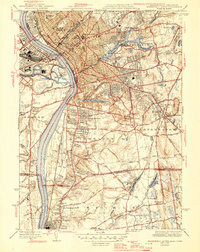
(27)- 1901 Map of Holyoke
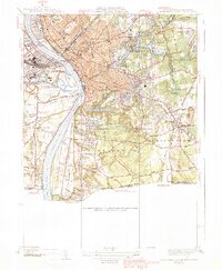
 1901 Holyoke1901 Print · USGSThe Pioneer Valley and surrounding highlands thrive at the turn of the century, showing a landscape defined by mill towns and early rail networks. Genealogists and historians can trace old homesteads and local landmarks like Bisbee Mill, South Ferry, and the Agricultural College.4 unique versions available
 - 1908 Map of Ware
 1908 Ware1908 Print · USGSCentral Massachusetts at the turn of the century reveals the Swift River Valley decades before the Quabbin Reservoir changed the landscape forever. Trace the lost footprints of Enfield and Dana, or follow the Central Vermont RR through Greenwich Village and Ware.2 unique versions available
 - 1919 Map of Palmer
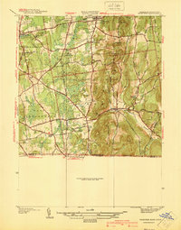
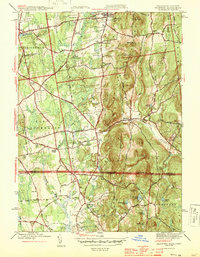
 1919 Palmer1919 Print · USGSHampden County and the Connecticut borderlands are captured here during the height of the steam-rail era. Genealogists and historians can trace the foundations of local industry at Fosketts Mill, the Granite Quarry, and the sprawling Monson State Hospital.
 - 1920 Map of Springfield
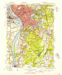
 1920 Springfield1920 Print · USGSGreater Springfield and the Pioneer Valley are captured here during a period of intense industrial and rail expansion. Genealogists and local historians can trace the foundations of neighborhoods like Indian Orchard, locate the Shaker Sta, or study the early rail alignments of the Boston and Albany RR.
 - 1928 Map of Long Meadow
 1928 Long Meadow1928 Print · USGSNorth-central Connecticut and the Massachusetts border are captured here in the late twenties, showing the region's transition into the modern era. Genealogists can trace the rail-and-river network through Thompsonville and find the site of Shaker Sta.
 - 1933 Map of Longmeadow
 1933 Longmeadow1933 Print · USGSThe Connecticut River valley thrives in the early 1930s as a hub of industry, education, and transport. Researchers can trace historic family plots at Springfield Cemetery or locate old rail hubs like Union Station and the Longmeadow Sta.
 - 1938 Map of Springfield South
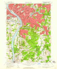
 1938 Springfield South1938 Print · USGSSpringfield and its southern neighbors appear here in the late 1930s, showing a bustling industrial city and its growing suburbs before postwar change. Researchers can trace historic rail lines through Union Sta or locate family plots in Oak Grove Cemetery and St Michaels Cemetery.3 unique versions available
 - 1939 Map of Hampden
 1939 Hampden1939 Print · USGSHampden and Wilbraham are captured here just before the mid-century expansion of the Springfield suburbs. Researchers can trace historic local sites like Wilbraham Academy, find family names at Prospect Hill Cem, and locate the small settlement of Baptist Village.
 - 1939 Map of Springfield South
 1939 Springfield South1939 Print · USGSThe Pioneer Valley hums with industrial and civic energy in the late thirties as rail hubs and river crossings define the landscape. Trace the urban layout of Springfield through landmarks like the U S Armory, Union Sta, and Oak Grove Cemetery.2 unique versions available
 - 1940 Map of Hampden
 1940 Hampden1940 Print · USGSMassachusetts and Connecticut borderlands meet at the edge of the Berkshires in the late thirties. Local historians can trace old homesteads and community hubs near Baptist Village, Woodland Dell Cem, and the high peak of Minnechoag Mountain.2 unique versions available
 - 1942 Map of Hampden
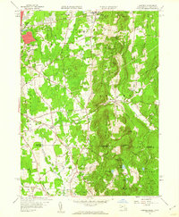
 1942 Hampden1942 Print · USGSThe Pioneer Valley foothills are captured here in the years before the war, showing the rural character of Hampden and Wilbraham. Genealogists and historians can locate family-named sites such as Adams Cem, Baptist Village, and the Stony Hill Sch.
 - 1942 Map of Ware
 1942 Ware1942 Print · USGSCentral Massachusetts and the Connecticut border are captured here during the early years of the war, just as the landscape was being reshaped by the Quabbin Reservoir. Researchers can trace rail-era industry and local landmarks like the Lead Mine and the Bald Peak Hospital.
 - 1943 Map of Holyoke
 1943 Holyoke1943 Print · USGSThe Pioneer Valley and the eastern Berkshires are captured here in the early 1940s, showing a robust network of river-side industry and hill-country forests. Researchers can locate vanished landmarks and institutional grounds like Northampton State Hospital, Barnes Airport, and the Nat Gd Rifle Range.
 - 1944 Map of Hampden
 1944 Hampden1944 Print · USGSThe Massachusetts-Connecticut borderlands come to life in the 1940s, showing the early suburban growth around Sixteen Acres and Hampden. Genealogists can locate family landmarks like Adams Cem, Wilbraham Academy, and the village of Baptist Village.4 unique versions available
 - 1944 Map of Springfield South, 1954 Print
 1944 Springfield South1954 Print · USGSGreater Springfield and the lower Connecticut River valley are captured here in the mid-1940s, showing a robust mix of industrial city centers and expanding southern suburbs. Trace local history through landmarks like the US Armory, the Osborn Prison Farm, and the historic Winchester Square.4 unique versions available
 - 1946 Map of Springfield South
 1946 Springfield South1946 Print · USGSThe Connecticut River valley thrives in the mid-1940s, transitioning from the industrial bustle of Springfield to the emerging suburbs of Longmeadow and Enfield. Genealogists and historians can trace institutional landmarks like the U S Armory, St Michaels Cemetery, and the Osborn Prison Farm.2 unique versions available
 - 1946 Map of Hampden, 1956 Print
 1946 Hampden1956 Print · USGSThe Massachusetts-Connecticut borderlands appear here in the mid-forties, showing a mix of established academy towns and expanding residential pockets. Trace the historical roots of Baptist Village, locate the grounds of Wilbraham Academy, or find the secluded Glendale Ch among the eastern hills.
 - 1948 Map of Albany, 1951 Print
 1948 Albany1951 Print · USGSThe Hudson and Connecticut River valleys are captured here in the late 1940s, showing the vital rail and water corridors of the Northeast. You can trace the Boston and Maine tracks past Mt Greylock or locate early settlements like Great Barrington and Bennington.
 - 1956 Map of Albany, 1968 Print
 1956 Albany1968 Print · USGSThe industrial heart of the Northeast is revealed in the mid-1950s, from the Hudson Valley to the Connecticut River. Researchers can trace the legacy of the Quabbin Reservoir, locate Westover Air Force Base, or follow the Rutland RR through the Green Mountains.2 unique versions available
 - 1957 Map of Albany
 1957 Albany1957 Print · USGSThe Tri-State region and Connecticut River Valley are captured here during a period of significant postwar growth and infrastructure expansion. Genealogists and historians can trace the rail-and-river economy through landmarks like the Boston and Maine railroad, Quabbin Reservoir, and Westover Air Force Base.
 - 1958 Map of Springfield South, 1960 Print
 1958 Springfield South1960 Print · USGSThe Connecticut River valley at the close of the 1950s shows the bustling urban center of Springfield expanding into its southern suburbs and across the state line. Genealogists can locate family names at Oak Grove Cemetery or trace early schoolhouses like Brainard Sch and Phelps Sch.6 unique versions available
 - 1958 Map of Hampden, 1960 Print
 1958 Hampden1960 Print · USGSThe Massachusetts-Connecticut borderlands appear here in the late fifties, showing the residential expansion of Springfield meeting the steep ridge of the Wilbraham Mountains. Researchers can trace old family landmarks and civic sites like Wilbraham Academy, the Landing Field, and Woodland Dell Cem.5 unique versions available
 - 1959 Map of Albany
 1959 Albany1959 Print · USGSThe Hudson and Connecticut River valleys are captured here during the late fifties, showing the region's dense rail networks and massive water projects. Researchers can trace the New York State Thruway or locate local landmarks like Mt Greylock and the Quabbin Reservoir.
 - 1962 Map of Albany
 1962 Albany1962 Print · USGSThe Hudson and Connecticut River valleys meet the Green Mountains and Berkshires in this mid-century overview of the Northeast. Genealogists and historians can trace the industrial hearts of Albany and Springfield or locate features like Quabbin Reservoir and Westover Air Force Base.
 - 1975 Map of Springfield South, 1981 Print
 1975 Springfield South1981 Print · USGSThe Pioneer Valley comes into sharp focus during the mid-1970s, showing the industrial and residential growth along the Connecticut River. Researchers can trace the mid-century footprints of Springfield, West Springfield, and Thompsonville through high-resolution aerial imagery.
Showing maps 1-25 of 27
Top cities near East Longmeadow
- Springfield historical maps
- Chicopee historical maps
- Enfield historical maps
- Westfield historical maps
- Holyoke historical maps
- Vernon historical maps
See more
Top neighborhoods of East Longmeadow
Frequently asked questions
- What are the different types of historical maps available for East Longmeadow?
- What is the oldest map of East Longmeadow?
- Where can I purchase historical maps of East Longmeadow for my home or office?
- Where can I download high-res historical maps of East Longmeadow?
- Are there historical topographic maps available for East Longmeadow?
- Is there historical aerial imagery available for East Longmeadow?
- Where are historical maps of East Longmeadow sourced from?