Old Maps of Cummington Farm Village, Cummington for Genealogy
Trace your family roots with 21 historic maps of Cummington Farm Village. These high-res maps reveal old neighborhoods, homesites, landmarks, and streets — helping you uncover where your ancestors lived and how the area evolved over time.
- Explore historic neighborhoods: Identify where your relatives may have lived in the 1800s or 1900s.
- Compare maps over time: Trace the changes in streets, buildings, and landmarks for multi-generational research.
- Perfect for genealogy & ancestry research: Used by family historians and researchers to map out lineage and migration.
These maps are an incredible resource for exploring your personal connection to Cummington Farm Village's past.
Cummington Farm Village, Cummington maps
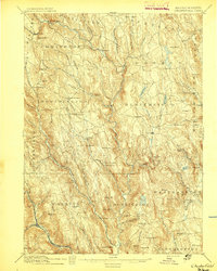
(21)- 1886 Map of Chesterfield
 1886 Chesterfield1886 Print · USGSCovers Cummington Farm Village, including Southampton, Williamsburg, and other nearby areas
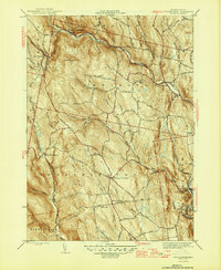
 - 1888 Map of Chesterfield
 1888 Chesterfield1888 Print · USGSCovers Cummington Farm Village, including Southampton, Williamsburg, and other nearby areas
 - 1893 Map of Chesterfield
 1893 Chesterfield1893 Print · USGSCovers Cummington Farm Village, including Southampton, Williamsburg, and other nearby areas
 - 1895 Map of Chesterfield
 1895 Chesterfield1895 Print · USGSCovers Cummington Farm Village, including Southampton, Williamsburg, and other nearby areas8 unique versions available
 - 1896 Map of Holyoke
 1896 Holyoke1896 Print · USGSCovers Cummington Farm Village, including Springfield, Chicopee, and other nearby areas
 - 1897 Map of Holyoke
 1897 Holyoke1897 Print · USGSCovers Cummington Farm Village, including Springfield, Chicopee, and other nearby areas
 - 1901 Map of Holyoke
 1901 Holyoke1901 Print · USGSCovers Cummington Farm Village, including Springfield, Chicopee, and other nearby areas4 unique versions available
 - 1943 Map of Holyoke
 1943 Holyoke1943 Print · USGSCovers Cummington Farm Village, including Springfield, Chicopee, and other nearby areas
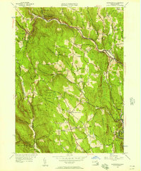
 - 1946 Map of Worthington
 1946 Worthington1946 Print · USGSCovers Cummington Farm Village, including Chesterfield, Worthington, and other nearby areas2 unique versions available
 - 1948 Map of Albany, 1951 Print
 1948 Albany1951 Print · USGSCovers Cummington Farm Village, including Springfield, Albany, and other nearby areas
 - 1956 Map of Worthington, 1957 Print
 1956 Worthington1957 Print · USGSCovers Cummington Farm Village, including Chesterfield, Worthington, and other nearby areas2 unique versions available
 - 1956 Map of Albany, 1968 Print
 1956 Albany1968 Print · USGSCovers Cummington Farm Village, including Springfield, Albany, and other nearby areas2 unique versions available
 - 1957 Map of Albany
 1957 Albany1957 Print · USGSCovers Cummington Farm Village, including Springfield, Albany, and other nearby areas
 - 1959 Map of Albany
 1959 Albany1959 Print · USGSCovers Cummington Farm Village, including Springfield, Albany, and other nearby areas
 - 1962 Map of Albany
 1962 Albany1962 Print · USGSCovers Cummington Farm Village, including Springfield, Albany, and other nearby areas
 - 1972 Map of Worthington, 1973 Print
 1972 Worthington1973 Print · USGSCovers Cummington Farm Village, including Chesterfield, Worthington, and other nearby areas2 unique versions available
 - 1975 Map of Worthington, 1981 Print
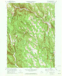
 1975 Worthington1981 Print · USGSCovers Cummington Farm Village, including Chesterfield, Worthington, and other nearby areas
 - 1985 Map of Holyoke, 1986 Print
 1985 Holyoke1986 Print · USGSCovers Cummington Farm Village, including Springfield, Chicopee, and other nearby areas2 unique versions available
 - 1990 Map of Goshen
 1990 Goshen1990 Print · USGSCovers Cummington Farm Village, including Williamsburg, Conway, and other nearby areas
 - 1997 Map of Goshen, 1999 Print
 1997 Goshen1999 Print · USGSCovers Cummington Farm Village, including Williamsburg, Conway, and other nearby areas
 - 2024 Map of Worthington, 2024 Print
 2024 Worthington2024 Print · USGSCovers Cummington Farm Village, including Chesterfield, Worthington, and other nearby areas
End of results
Showing maps 1-21 of 21
Frequently asked questions
- What are the different types of historical maps available for Cummington Farm Village?
- What is the oldest map of Cummington Farm Village?
- Where can I purchase historical maps of Cummington Farm Village for my home or office?
- Where can I download high-res historical maps of Cummington Farm Village?
- Are there historical topographic maps available for Cummington Farm Village?
- Is there historical aerial imagery available for Cummington Farm Village?
- Where are historical maps of Cummington Farm Village sourced from?