1960s Maps of Hatfield, Massachusetts
Explore 4 historic maps of Hatfield from the 1960s. These maps offer a rare glimpse into what life looked like during the 1960s — showing old roads, neighborhoods, homes, and landmarks that have changed or disappeared over time.
Whether you're researching your family's past, planning a metal detecting trip, or studying how Hatfield's landscape evolved across the 1960s, these high-resolution maps are a powerful tool for exploring the history of this region.
- Focus on a specific era: All maps on this page are from the 1960s, giving you a focused view of this time period.
- See what’s changed: Compare century-old streets, trails, and buildings to today's modern landscape using overlays and satellite layers.
- Research with precision: Use these maps for genealogy, historical research, land use analysis, or educational projects.
- View, download, or print: Maps are fully viewable online in high resolution, and can be downloaded or printed for your own records.
Start exploring Hatfield's history through authentic maps from the 1960s. This is your window into the past.
Hatfield, MA maps
(4)- 1962 Map of Albany
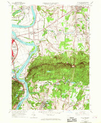
 1962 Albany1962 Print · USGSThe Hudson and Connecticut River valleys meet the Green Mountains and Berkshires in this mid-century overview of the Northeast. Genealogists and historians can trace the industrial hearts of Albany and Springfield or locate features like Quabbin Reservoir and Westover Air Force Base.
 - 1964 Map of Williamsburg, 1966 Print
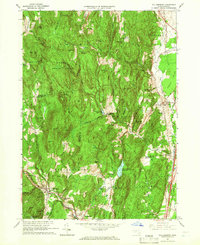 1964 Williamsburg1966 Print · USGSThe Pioneer Valley foothills and Hill Towns come to life in the mid-1960s, showing the intersection of rail, river, and mountain. Genealogists can trace family roots through the Whately Center Cem or locate the old Williamsburg Station along the Boston and Maine Railroad.4 unique versions available
 - 1964 Map of Mt Holyoke, 1967 Print
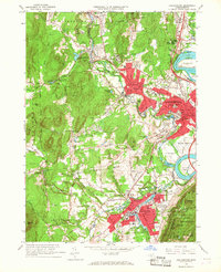
 1964 Mt Holyoke1967 Print · USGSThe Pioneer Valley mid-century is defined by the winding Connecticut River and the prominent ridges of the Holyoke Range. Researchers can trace the footprints of Amherst College, the historic Old Hadley Cem, and local landmarks like Titans Piazza.7 unique versions available
 - 1964 Map of Easthampton, 1967 Print
 1964 Easthampton1967 Print · USGSNorthampton and Easthampton are shown at a peak of mid-century development, framed by the Connecticut River and the Sawmill Hills. Genealogists and historians can trace institutional landmarks like Smith College, Williston Academy, and St Marys Cem.3 unique versions available
End of results
Showing maps 1-4 of 4
Top cities near Hatfield
- Springfield historical maps
- Chicopee historical maps
- Westfield historical maps
- Holyoke historical maps
- Amherst historical maps
- Northampton historical maps
See more
Top neighborhoods of Hatfield
- Bradstreet historical maps
- North Hatfield historical maps
- West Hatfield historical maps
- Westbrook historical maps
- Old Mill Site Historic District historical maps
Frequently asked questions
- What are the different types of historical maps available for Hatfield?
- What is the oldest map of Hatfield?
- Where can I purchase historical maps of Hatfield for my home or office?
- Where can I download high-res historical maps of Hatfield?
- Are there historical topographic maps available for Hatfield?
- Is there historical aerial imagery available for Hatfield?
- Where are historical maps of Hatfield sourced from?