1970s Maps of West Hawley, Plainfield
Explore 2 historic maps of West Hawley from the 1970s. These maps offer a rare glimpse into what life looked like during the 1970s — showing old roads, neighborhoods, homes, and landmarks that have changed or disappeared over time.
Whether you're researching your family's past, planning a metal detecting trip, or studying how West Hawley's landscape evolved across the 1970s, these high-resolution maps are a powerful tool for exploring the history of this region.
- Focus on a specific era: All maps on this page are from the 1970s, giving you a focused view of this time period.
- See what’s changed: Compare century-old streets, trails, and buildings to today's modern landscape using overlays and satellite layers.
- Research with precision: Use these maps for genealogy, historical research, land use analysis, or educational projects.
- View, download, or print: Maps are fully viewable online in high resolution, and can be downloaded or printed for your own records.
Start exploring West Hawley's history through authentic maps from the 1970s. This is your window into the past.
West Hawley, Plainfield maps
(2)- 1971 Map of Plainfield, 1973 Print
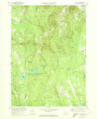 1971 Plainfield1973 Print · USGSThe Massachusetts highlands of the early 1970s reveal a landscape of dense state forests and quiet upland hamlets. Genealogists and hikers can trace old family burial grounds like Hilltop Cem or explore landmarks such as Windsor Jambs and Plainfield Pond.2 unique versions available
 - 1975 Map of Plainfield, 1981 Print
 1975 Plainfield1981 Print · USGSThe hill towns of western Massachusetts appear in the mid-1970s as a landscape of dense timber and quiet rural crossroads. Researchers can trace the exact footprint of settlements like West Hawley and Plainfield or find the remote shores of Windsor Pond.
End of results
Showing maps 1-2 of 2
Top cities near West Hawley
- Northampton historical maps
- North Adams historical maps
- Adams historical maps
- Williamstown historical maps
- Dalton historical maps
- Lee historical maps
See more
Frequently asked questions
- What are the different types of historical maps available for West Hawley?
- What is the oldest map of West Hawley?
- Where can I purchase historical maps of West Hawley for my home or office?
- Where can I download high-res historical maps of West Hawley?
- Are there historical topographic maps available for West Hawley?
- Is there historical aerial imagery available for West Hawley?
- Where are historical maps of West Hawley sourced from?