1970s Maps of Middlesex County, Massachusetts
Explore 26 historic maps of Middlesex County from the 1970s. These maps offer a rare glimpse into what life looked like during the 1970s — showing old roads, neighborhoods, homes, and landmarks that have changed or disappeared over time.
Whether you're researching your family's past, planning a metal detecting trip, or studying how Middlesex County's landscape evolved across the 1970s, these high-resolution maps are a powerful tool for exploring the history of this region.
- Focus on a specific era: All maps on this page are from the 1970s, giving you a focused view of this time period.
- See what’s changed: Compare century-old streets, trails, and buildings to today's modern landscape using overlays and satellite layers.
- Research with precision: Use these maps for genealogy, historical research, land use analysis, or educational projects.
- View, download, or print: Maps are fully viewable online in high resolution, and can be downloaded or printed for your own records.
Start exploring Middlesex County's history through authentic maps from the 1970s. This is your window into the past.
Middlesex County, MA maps
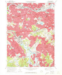
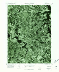
(26)- 1970 Map of Natick, 1972 Print
 1970 Natick1972 Print · USGSSuburban Boston expands through Middlesex and Norfolk counties in the 1970s, showcasing a landscape of elite universities and crucial water infrastructure. Researchers can trace the Cochituate Aqueduct and locate landmarks like Wellesley College or the Natick Laboratories (U S Army).2 unique versions available
 - 1970 Map of Concord, 1972 Print
 1970 Concord1972 Print · USGSThe revolutionary and literary landscapes of Middlesex County are captured here in the decades following the war. Genealogists and historians can trace family plots in the Old Burying Ground or locate landmarks like Meryams Corner and the Davis Sch.3 unique versions available
 - 1970 Map of Medfield, 1972 Print
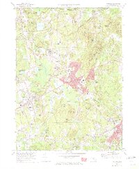 1970 Medfield1972 Print · USGSMedfield and Millis are shown during a period of transition in the early seventies, as suburban growth met the legacy of the area's older institutional and rail infrastructure. Researchers can trace the extensive Medfield State Hospital grounds, historic burial sites like Vine Lake Cemetery, and the Penn Central rail lines.2 unique versions available
 - 1970 Map of Boston South, 1973 Print
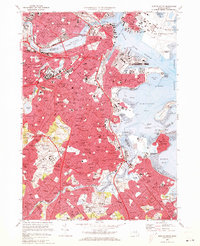 1970 Boston South1973 Print · USGSBoston and its southern neighborhoods are shown at a peak of urban development in the early seventies. Genealogists and historians can trace family roots through the dense streets of Dorchester or locate ancestral plots in Cedar Grove Cem and New Calvary Cem.2 unique versions available
 - 1970 Map of Newton, 1973 Print
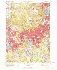
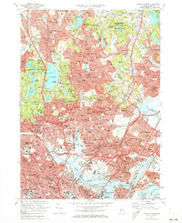
 1970 Newton1973 Print · USGSThe western suburbs of Boston reached a peak of mid-century density during this era of highway and rail expansion. Researchers can trace historic parish boundaries and burial sites like Newton Cemetery or locate landmarks like Boston College and the Arnold Arboretum.2 unique versions available
 - 1971 Map of Boston North, 1973 Print
 1971 Boston North1973 Print · USGSThe northern reaches of the Massachusetts capital show a landscape of dense suburbs and protected woodlands in the early seventies. Researchers can locate landmark sites like the Bunker Hill Monument, trace the MBTA System rail lines, or explore the grounds of Harvard University and Holy Cross Cemetery.2 unique versions available
 - 1971 Map of Lexington, 1973 Print
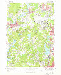
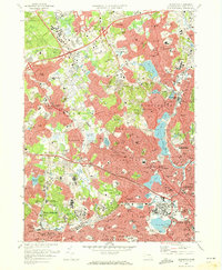 1971 Lexington1973 Print · USGSThe suburban landscape of Middlesex County is shown here in the early 1970s as historic town centers integrated with major institutional and commercial developments. Genealogists and historians can locate dozens of neighborhood schools, local churches, and expansive grounds such as Mc Lean Hospital and St Patricks Cem.2 unique versions available
 - 1975 Map of Shrewsbury, 1981 Print
 1975 Shrewsbury1981 Print · USGSCentral Massachusetts suburbs undergo visible post-war transformation in the mid-seventies as seen through this detailed aerial survey. Trace the residential growth near Shrewsbury and Northborough or locate early development around Lake Quinsigamond.
 - 1975 Map of Townsend, 1981 Print
 1975 Townsend1981 Print · USGSMiddlesex County's rural northern reaches are captured in the mid-seventies, showing the density of forest and river-valley settlements. Trace the residential layouts of Townsend, Old City, and the banks of the Squannacook River.
 - 1975 Map of Ashburnham, 1981 Print
 1975 Ashburnham1981 Print · USGSNorthern Worcester County and the New Hampshire borderlands are visible in this mid-seventies aerial study. Local historians can trace the early residential footprints of Lane Village and Wellville or examine the shoreline of Lake Monomonac.
 - 1975 Map of Shirley, 1981 Print
 1975 Shirley1981 Print · USGSNorthern Worcester County in the mid-seventies is documented here through high-altitude aerial photography. Trace the rural-to-suburban transition around Lunenburg and the riverbanks of the Nashua River and Squannacook River.
 - 1977 Map of Boston South, 1980 Print
 1977 Boston South1980 Print · USGSThe Boston metropolitan area is captured in the late seventies through detailed aerial photography, showing the city's dense urban layout and harbor. Trace the industrial waterfront of Boston Harbor or follow the Neponset River as it winds toward Squantum.
 - 1977 Map of Milford, 1980 Print
 1977 Milford1980 Print · USGSIn the late 1970s, the Blackstone Valley corridor was undergoing a period of rapid suburban growth. Genealogists and historians can trace the street-level development of Milford and Hopedale, or study the landscape around North Pond.
 - 1977 Map of Boston North, 1980 Print
 1977 Boston North1980 Print · USGSThe northern suburbs of Boston come into focus in the late 1970s through this detailed orthophotoquad survey. Trace the urban landscape from the Mystic River waterfront to the dense neighborhoods of Malden, Everett, and Revere.
 - 1977 Map of Newton, 1980 Print
 1977 Newton1980 Print · USGSThe western suburbs of Boston are revealed in detail during the late seventies, showing the dense development of these historic townships. Trace the winding Charles River through Newton, Brookline, and Watertown to see the region's layout.
 - 1977 Map of Lexington, 1980 Print
 1977 Lexington1980 Print · USGSSuburban Middlesex County comes into sharp focus in the late seventies as residential growth fills the spaces between historic township centers. Researchers can trace the mid-century street patterns of Lexington, Arlington, and Waltham or follow the course of the Aberjona River.
 - 1977 Map of Reading, 1980 Print
 1977 Reading1980 Print · USGSNortheastern Massachusetts towns show their modern footprints in the late seventies as residential growth surrounds traditional river corridors. Trace the development of North Reading, Peabody, and Reading along the Ipswich River.
 - 1977 Map of Wilmington, 1980 Print
 1977 Wilmington1980 Print · USGSWilmington and its Middlesex County neighbors are shown during the suburban surge of the late seventies. Researchers can trace the development of residential neighborhoods in Burlington and Pinehurst or locate landmarks near Silver Lake.
 - 1977 Map of Holliston, 1981 Print
 1977 Holliston1981 Print · USGSHolliston and the surrounding Massachusetts towns are shown in sharp photographic detail during the late seventies. Researchers can trace property boundaries and land development near Holliston, West Medway, and the banks of the Charles River.
 - 1977 Map of Hudson, 1981 Print
 1977 Hudson1981 Print · USGSMiddlesex County emerges from its agrarian past into a burgeoning suburban era in this late-seventies aerial study. Researchers can trace land development around the Assabet River or locate family sites in Hudson, Bolton, and Stow.
 - 1977 Map of Concord, 1981 Print
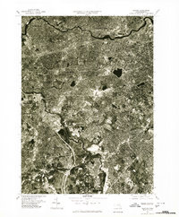
 1977 Concord1981 Print · USGSMiddlesex County communities appear in transition during the late seventies, captured in this detailed aerial orthophotoquad. Researchers can trace the exact 1977 footprints of Concord and Lexington or locate the Cambridge Reservoir.
 - 1977 Map of Framingham, 1981 Print
 1977 Framingham1981 Print · USGSMiddlesex County emerges in high detail in the late seventies as suburban growth reshapes the landscape west of Boston. Trace the residential layout of Framingham and the industrial footprint near the Sudbury Reservoir and Ashland.
 - 1977 Map of Natick, 1981 Print
 1977 Natick1981 Print · USGSSuburban development and ancient river courses meet in this late-1970s aerial survey of Middlesex County. Genealogists and historians can trace the mid-century growth of Natick and Wellesley alongside the winding Charles River.
 - 1977 Map of Maynard, 1981 Print
 1977 Maynard1981 Print · USGSMiddlesex County enters the late seventies as a landscape of historic mill towns and growing residential corridors. Trace the development of Maynard and West Concord along the banks of the Assabet River.
 - 1977 Map of Medfield, 1981 Print
 1977 Medfield1981 Print · USGSNorfolk County is seen through the lens of late-seventies aerial photography, capturing the area's transition between rural roots and suburban growth. Trace local land use and development patterns near Medfield, Millis, and the winding Charles River.
Showing maps 1-25 of 26
Top cities of Middlesex County
- Lowell historical maps
- Cambridge historical maps
- Newton historical maps
- Somerville historical maps
- Framingham historical maps
- Waltham historical maps
See more
Frequently asked questions
- What are the different types of historical maps available for Middlesex County?
- What is the oldest map of Middlesex County?
- Where can I purchase historical maps of Middlesex County for my home or office?
- Where can I download high-res historical maps of Middlesex County?
- Are there historical topographic maps available for Middlesex County?
- Is there historical aerial imagery available for Middlesex County?
- Where are historical maps of Middlesex County sourced from?