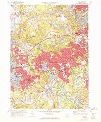
1970 Map of Natick
USGS Topo · Published 1972About this map
Wellesley College, Brandeis University, and Regis College anchor this detailed view of the western suburbs as they appeared in 1970. The landscape is a complex mix of academic institutions, residential expansion, and significant utility infrastructure, including the visible paths of the Cochituate Aqueduct and Sudbury Aqueduct cutting across the terrain. Large-scale public and private land use is evident at the Natick Laboratories (U S Army) and the Mass Nat Guard Supply Depot, while the riverine character of the area is defined by the winding Sudbury River and Charles River. The expansion of the Mass Pike and the active lines of the Penn Central railroad highlight the transportation networks that fueled the growth of Natick, Wellesley, and Wayland during the late twentieth century.
Find a feature on this map
118 named features on this map. Tap any name to fly to it.
Don’t see what you’re looking for? This feature index may not catch every label — zoom into the map to look around manually.
Map Details
Editions of this 1970 Natick Map
2 editions found
Other maps of this area

1886 · Dedham
USGS Topo · 1:62,500

1886 · Framingham
USGS Topo · 1:62,500

1887 · Franklin
USGS Topo · 1:62,500

1889 · Franklin
USGS Topo · 1:62,500

1889 · Framingham
USGS Topo · 1:62,500

1893 · Franklin
USGS Topo · 1:62,500

1893 · Boston
USGS Topo · 1:62,500

1894 · Dedham
USGS Topo · 1:62,500

1894 · Framingham
USGS Topo · 1:62,500

1903 · Boston
USGS Topo · 1:62,500