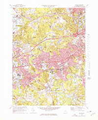
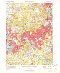
1970 Map of Natick
USGS Topo · Published 1978About this map
Natick and Wellesley stand as the central hubs in this suburbanizing landscape west of Boston during the 1970s. The map illustrates a region defined by established academic and military institutions, including the expansive Natick Laboratories (US Army) near Lake Cochituate and several prominent campuses such as Regis College, Brandeis University, and Babson College. The development pattern shows the heavy influence of post-war infrastructure, with the Massachusetts Turnpike and the Penn Central rail lines cutting through the terrain to connect these growing residential areas to the urban core.
Find a feature on this map
126 named features on this map. Tap any name to fly to it.
Don’t see what you’re looking for? This feature index may not catch every label — zoom into the map to look around manually.
Map Details
Editions of this 1970 Natick Map
2 editions found
Other maps of this area

1886 · Dedham
USGS Topo · 1:62,500

1886 · Framingham
USGS Topo · 1:62,500

1887 · Franklin
USGS Topo · 1:62,500

1889 · Franklin
USGS Topo · 1:62,500

1889 · Framingham
USGS Topo · 1:62,500

1893 · Franklin
USGS Topo · 1:62,500

1893 · Boston
USGS Topo · 1:62,500

1894 · Dedham
USGS Topo · 1:62,500

1894 · Framingham
USGS Topo · 1:62,500

1903 · Boston
USGS Topo · 1:62,500